Download
1 / 12
120 likes | 139 Vues
Utilize GeoMapApp to investigate subduction zones, assess factors influencing dip angles, convergence rates, and lithosphere ages. Analyze seismic data to understand subduction behaviors in different regions.

E N D
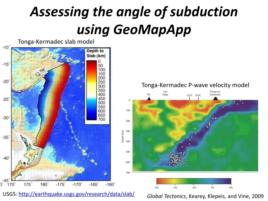
Assessing the angle of subduction using GeoMapApp Tonga-Kermadec slab model Tonga-Kermadec P-wave velocity model USGS: http://earthquake.usgs.gov/research/data/slab/ Global Tectonics, Kearey, Klepeis, and Vine, 2009
Content goal -Examine relationship between subduction angle, oceanic lithosphere age, and convergence rate Higher order thinking goals -Formulation of hypotheses -Analysis of large datasets -Synthesis of ideas Skills goals -Ability to access online databases and mapping programs
Description -Use GeoMapApp to examine datasets from four different subduction zones -Directed homework assignment to aid in interpretation of data Assessment -Students submit completed homework assignment with answers to questions and images from GeoMapApp
Collecting and organizing earthquake data Tonga-Kermadec earthquakes (1973–2009)
Collecting and organizing earthquake data Which subduction zones have the largest earthquakes? Which subduction zones have the deepest earthquakes? Which subduction zones have the most earthquakes? Based on these data, which subduction zones are most seismically active? Based on the depth, magnitude, and frequency, discuss the possible prominent causes for the earthquakes at each of these subduction zones?
Determining the dip angle of subduction Tonga-Kermadec subduction zone interface with profile
Determining the dip angle of subduction Tonga-Kermadec profile across subduction zone
Determining the dip angle of subduction What are the dip angles of subduction for each of these subduction zones? Are these subduction dip angles what were expected? Explain. What could be causes for the differences in dip angle of subduction for each of the regions?
Assessing the factors that influence dip angle Age of oceanic lithosphere in Tonga-Kermadec region Plate motion calculator: http://www.unavco.org/community_science/science-support/crustal_motion/dxdt/model.html
Assessing the factors that influence dip angle What are the estimated convergence rates? What are the oceanic lithosphere ages? Does the convergence rate influence subduction dip angle? Does the oceanic lithosphere age influence subduction dip angle?
Summary questions and synthesis of course material What other factors may have a significant influence on subduction dip angle? Why do some subduction zones have deep earthquakes, whereas other subduction zones do not? How do the factors that influence subduction dip angle also influence the type of accretionary orogen? Describe the possible types of accretionary orogens and determine what types of orogens these four subduction systems represent