Download

1 / 36
370 likes | 529 Vues
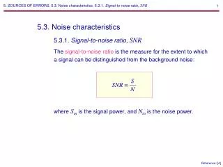
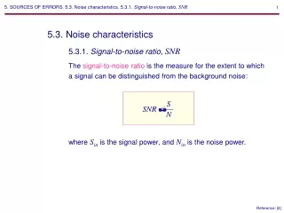
Mapping the GPS Multipath Environment Using the Signal-to-Noise Ratio (SNR). Andria Bilich*, Kristine M. Larson +. * Geosciences Research Division, National Geodetic Survey + Department of Aerospace Engineering Sciences, University of Colorado, Boulder. Overview. GPS system basics

E N D
Mapping the GPS Multipath Environment Using the Signal-to-Noise Ratio (SNR) Andria Bilich*, Kristine M. Larson+ * Geosciences Research Division, National Geodetic Survey + Department of Aerospace Engineering Sciences, University of Colorado, Boulder
Overview • GPS system basics • Motivation: multipath with GPS signals • Why do we care? • What do we know? • Measurement: SNR • Technique: power spectral maps National Geodetic Survey National Oceanic and Atmospheric Administration
Global Positioning System (GPS) • Radio navigation system • L-band • 1575.42 MHz (L1) • 1227.60 MHz (L2) • 28+ satellites • CDMA • Global coverage • 4-10 in view at any instant courtesy of Dept. of Defense National Geodetic Survey National Oceanic and Atmospheric Administration
A rA B rB C rC Positioning with GPS • Trilateration using distance to satellites • Must have accurate satellite-receiver range National Geodetic Survey National Oceanic and Atmospheric Administration
Multipath with GPS • Multipath • Range error = positioning error • Systematic (quasi-sinusoidal) • Large magnitude • Site-specific National Geodetic Survey National Oceanic and Atmospheric Administration
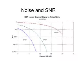
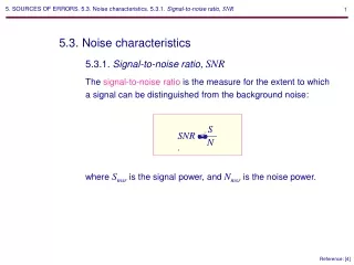
multipath composite direct Signal-to-Noise Ratio (SNR) • SNR = strength of composite signal • Phase relationship changes with satellite motion Multipath strength National Geodetic Survey National Oceanic and Atmospheric Administration
Multipath Oscillations in SNR Parameters affecting multipath frequency: • Reflector distance h • Reflection angle • GPS wavelength Multipath frequency National Geodetic Survey National Oceanic and Atmospheric Administration
Ground Distance vs. Multipath Period Fast MP = far away Slow MP = nearby For a fixed reflector, satellite motion generates time-varying signature National Geodetic Survey National Oceanic and Atmospheric Administration
Multipath and SNR:putting it all together • Frequency = distance to reflector • Amplitude = multipath strength • Satellite position: • Azimuth/elevation = location of reflections relative to antenna • Rate of elevation change = impact on frequency and height National Geodetic Survey National Oceanic and Atmospheric Administration
SNR Data • Total SNR = direct plus reflected signal(s) • Direct amplitude = dominant trend • Multipath signal = superimposed on direct National Geodetic Survey National Oceanic and Atmospheric Administration
Power Spectral Maps • Wavelet spectra of detrended SNR • Assign frequency and power to satellite azimuth & elevation • Plot all points on a grid (sky map) National Geodetic Survey National Oceanic and Atmospheric Administration
Multipath from Nearby Structure: TRO1 • Antenna on a mast: • 4.09 m above ground surface • 1.3 m above flat tar-paper roof • Roof to S of antenna National Geodetic Survey National Oceanic and Atmospheric Administration
TRO1 Power Maps • High power at long periods = close-in reflector National Geodetic Survey National Oceanic and Atmospheric Administration
Multipath from Distant Topography: MKEA Mauna Kea (MKEA), Hawaii National Geodetic Survey National Oceanic and Atmospheric Administration
MKEA Power Maps 30-60s 10-30s 60-90s • Frequency (distance to reflector) changes with satellite position • High power returns from cinder cones National Geodetic Survey National Oceanic and Atmospheric Administration
Combined Multipath Environments: KYVW • Standard GPS monument ~ 1.8m above ground • Nearfield: sandy, flat ground • Farfield: gentle hillsides to NW and E National Geodetic Survey National Oceanic and Atmospheric Administration
KYVW Power Maps Ground reflections Long periods (L1) Short periods (L2) Reflections from hillsides National Geodetic Survey National Oceanic and Atmospheric Administration
Summary National Geodetic Survey National Oceanic and Atmospheric Administration
Acknowledgements • Tools: • Torrence and Compo wavelet toolbox: http://paos.colorado.edu/research/wavelets/ • Generic Mapping Tools (GMT) • IGS, CORS, SOPAC, UNAVCO, JPL • NSF grants and fellowships Bilich, A., K.M. Larson (2007) Mapping the GPS multipath environment using the signal-to-noise ratio (SNR), Radio Science, 42, RS6003. National Geodetic Survey National Oceanic and Atmospheric Administration
Multipath Assessment:Power Spectral Maps • Idea: frequency and power content of SNR multipath environment • Method: • Wavelet spectra of detrended SNR • Assign frequency and power to satellite azimuth/elevation • Plot all points on a grid (sky map) National Geodetic Survey National Oceanic and Atmospheric Administration
Mauna Kea (MKEA) National Geodetic Survey National Oceanic and Atmospheric Administration
What do these equations tell us? • Oscillations in SNR, phase MP, and pseudorange MP all have common frequency • MP frequency • Key to determining • Function of • Reflector distance h • Reflection angle • GPS wavelength Fast MP = far away Slow MP = nearby For a fixed reflector, satellite motion generates time-varying signature National Geodetic Survey National Oceanic and Atmospheric Administration
Time-evolving Multipath National Geodetic Survey National Oceanic and Atmospheric Administration
Understanding Multipath:Power Spectral Maps • Idea: frequency and power content of SNR multipath environment • Method: • Wavelet spectra of detrended SNR • Assign frequency and power to satellite azimuth/elevation • Plot all points on a grid (sky map) National Geodetic Survey National Oceanic and Atmospheric Administration
Dual-FrequencyPower Spectral Maps S1 S2 Reflection from distant object (building?) Reflection from nearby object (rock outcrops?) National Geodetic Survey National Oceanic and Atmospheric Administration
multipath composite direct Simplified Multipath Model and SNR • Recorded SNR = direct + multipath signal • Carrier phase error: • Code (pseudorange) error (short delay): MP composite direct multipath National Geodetic Survey National Oceanic and Atmospheric Administration
National Geodetic Survey National Oceanic and Atmospheric Administration
Take-home lessons:Environmental Imaging • Assess multipath environment • Frequency: distance to object • Amplitude: magnitude of errors due to object • Consider position errors at different frequencies (think high-rate GPS positioning) • No new equipment • SNR routinely recorded • … but need precise and accurate SNR related to multipath model (not always possible) National Geodetic Survey National Oceanic and Atmospheric Administration
Summary • Existing CGPS networks extended to unforeseen science applications • Sensing soil moisture • Understanding reflections and potential sources of error • Measuring displacements from short-period, transient phenomena National Geodetic Survey National Oceanic and Atmospheric Administration
Space Segment • 24+ satellites • Orbit • 26K km radius • 12 hour period • Stationary ground tracks • 6 orbital planes National Geodetic Survey National Oceanic and Atmospheric Administration
GPS signal (1) Receiver takes in… • 4-12 satellites (in view) • 2 L-band (1-2 GHz) frequencies • L1 = 1572.42 MHz • L2 = 1227.60 MHz • Signal components • Carrier (sinusoidal signal) • PRN code (data bits for satellite ID and ranging) • Navigation message (satellite position/velocity info) • Timing information National Geodetic Survey National Oceanic and Atmospheric Administration
C/A “Coarse acquisition” code Civil use Chip = 1s = 300m wavelength Range +/-30m P(Y) “Precision” code Military use Chip = 0.1 s = 30m wavelength Range +/-3m Encrypted (Y code) to limit access = anti-spoofing GPS signal (2)PRN codes 3 separate signals: • On L1 = C/A and P(Y) • On L2 = P(Y) only National Geodetic Survey National Oceanic and Atmospheric Administration
GNSSGlobal Navigation Satellite Systems All are L-band radio systems (~ 1100 -1600 MHz) Mostly free signals National Geodetic Survey National Oceanic and Atmospheric Administration
What is multipath? • Multipath introduces range error -> position error • Why is multipath such an issue? • Difficult to prevent • Difficult to model • Systematic error • Problematic for high-rate applications • How can we understand, characterize, or remove multipath? National Geodetic Survey National Oceanic and Atmospheric Administration
Multipath Geometry amplitudes angles h reflector distance angle of reflection satellite elevation angle path delay Addirect signal amplitude Ammultipath signal amplitude National Geodetic Survey National Oceanic and Atmospheric Administration