Aerial Surveys vs. Satellite Imaging: A Superior Approach to Hydrocarbon Data Analysis
Aerial surveys present significant advantages over satellite imaging in hydrocarbon data analysis. Key benefits include the ability to avoid cloud interference, higher resolution images (5x5m compared to standard 30x30m or 60x60m satellite images), and specialized equipment designed to detect hydrocarbon anomalies effectively. Satellite imaging often suffers from atmospheric distortion and limitations due to inadequate resolution and available data. Aerial surveys enable adaptive data processing through self-training algorithms, leading to more accurate and reliable results.

Aerial Surveys vs. Satellite Imaging: A Superior Approach to Hydrocarbon Data Analysis
E N D
Presentation Transcript
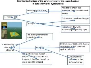
Significant advantage of the aerial survey over the space shooting in data analysis for hydrocarbons Possible to shoot the reference object(satellite-not always) Shooting route survey 1. The lay out Exclude the clouds on images Timing of the survey The time of day with maximum prospecting signs The atmosphere makes optical distortion Hydrometeor scattering (haze), absorption of the reflected optical radiation 2. Minimizing the atmosphere influence Humidity No mathematical model (impossible to compare two images, if the area takes 2 or more satellite images) Absorption of radiation in the infrared range
3. Higher resolution Satellite image Standard 30x30m or 60x60m Aerial photograph – 5х5m Today on satellites there is no specialized equipment to highlight anomalies, caused by hydrocarbons. Widely available images provide limited data for analysis, when compared to aerial photographs made by specialized equipment, i.e. hydrocarbon detection probability is lower. 4. Shooting with specialized equipment Aerial survey data processing, unlike satellite images, is distinguished by self-training algorithm, based on the reference object’ analysis. 5. Adaptive data processing