Download
1 / 24
250 likes | 296 Vues
Discover how NASA's ARSET program offers tailored remote sensing training to build capacity across multiple sectors worldwide through online and hands-on courses. Learn how to access and utilize satellite data for decision-making in various applications.

E N D
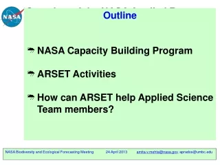
Overview of the NASA Applied Remote Sensing Training (ARSET) Program • Outline • NASA Capacity Building Program • ARSET Activities • How can ARSET help Applied Science Team members? A project of NASA Applied Sciences Amita V. Mehta and Ana I. Prados NASA-University of Maryland Baltimore County Joint Center for Earth Systems Technology (JCET) NASA Biodiversity and Ecological Forecasting Meeting 24 April 2013 amita.v.mehta@nasa.gov, aprados@umbc.edu
NASA’s Capacity Building Program • SERVIR Coordination Office (MSFC) • Building international capacity with hubs in • East Africa • Hindu Kush - Himalaya • Mesoamerica • Gulf of Mexico Initiative, GOMI (SSC) • Building Gulf region’s capacity for local environmental management • Applied Remote SEnsing Training, ARSET (GSFC) • On-line and hands on basic/advanced training tailored to end-uses organizations • DEVELOP (LaRC national office) • Dual student/local government capacity building using collaborative projects 1
NASA Earth ScienceApplied Sciences Program Weather Climate Disaster Management Ecological Forecasting Water Resources Public Health Agricultural Efficiency Applications to Decision Making: Thematic Areas
Applied Remote Sensing Training (ARSET) • Objectives • Provide end-users with professional technical workshops • Build long term partnerships with communities and institutions in the public and private sectors. • Online and hands-on courses: • Who: policy makers, environmental • managers, modelers and other professionals • in the public and private sectors. • Where: U.S. and internationally • When: throughout the year. • Do NOT require prior remote- sensing • background. • Presentations and guided computer • exercises and case studies on how to • access, interpret and use NASA satellite • images for decision-support. Hands on Training
ARSET Trainings Include:Remote Sensing and Numerical Modeling Data Basic in person course • For individuals and • institutions new to • remote sensing Basic online courses • Provide background material in preparation for in person trainings Advanced in person and online courses • Focused on a specific application/problem: for example monitoring fire and smoke in the western US (summer 2012), sever flooding in Mozambique (January 2013). • Requires basic online or in person course. Satellite Data In Situ Data Numerical Models
ARSET Training Activities • Advertise via list-serv and Webpage • Collaborate with NASA Applied Science PIs • Collaborate with NASA Data Centers • Identify end-users/host-institution • Discuss and plan training Conduct Training : Online Presentations Hands-on activities Case Studies Prepare Training Modules Project Evaluation: Surveys and Feedback
Basic Training • What is Remote Sensing? • Instruments/sensors and types • Types of satellite orbit around the • earth • Spatial and Temporal Resolutions • and Coverage • Overview of parameters available from NASA • Geophysical quantities derived from • satellite measurements • quality and accuracy of the • derived quantities • availability, access, format • applications and usage
Advanced Training • End-users requested and designed for their needs • Specific data parameters and applications • Learn: > details of data formats, download, analysis tools • > how to incorporate in Decision Support Tools • > Computer-based case studies Examples: Using AIRS CO to Track Forest Fire Plumes Flood Monitoring over Mozambique
Basic Training Web-Tools Access to imagery, Data analysis and visualization without downloading Examples: Giovannihttp://giovanni.gsfc.nasa.gov/ GLOVIShttp://glovis.usgs.gov/ Examples: Global Land Cover Facility http://glcf.umd.edu/data/ TRMM near-real time http://trmm.gsfc.nasa.gov/ Flood Monitoring publications_dir/potential_flood_hydro.html Advanced Training Web-Tools Data and Application Focus
Heavy Rain in Early May caused Severe Flooding in Tennessee, Arkansas Daily Precipitation (mm/day) 01 May 2011 0.5 10 20 30 40 50 TRMM-TMPA 3B42 Over a large area rainfall greater than 50 mm day was observed on 1 May 2011 From Giovanni web-tool
Lower Mississippi Flood Total Atmospheric Moisture Dramatically increased between April 30th and May 1, 2011 -- from MERRA From Giovanni web-tool
Lower Mississippi Flood Cloudiness increases between April 30th and May 1, 2011 -- from AIRS April 30 MAY 1 Ascending orbit Cloud fraction (fraction of a grid covered by clouds) – from 0 (totally cloud-free) to 1 (total overcast) Descending orbit Orbital Gaps From Giovanni web-tool
MODIS NDVI over US Southern Plains July 12-27 2010 July 12-27 2011 2010 Much sparser vegetation in 2012 From http://pekko.geog.umd.edu/usda/beta/
ARSET Trainings by Societal Benefit Area 2009 – March 2013: +800 End-users Reached Since 2008 Since 2011
Number of Trainings + Participating Organizations ARSET Trainings: 2009 – March 2013 Include: County State Tribal Academic Private Sector Does NOT include Federal Agencies: NOAA, USGS, USAID, USACE, BLM, Bureau Rec US Forest Service, National Park Service, EPA
ARSET Trainings International: 2009 – March 2013 ARSET Trainings International: 2009 – March 2013
Recent Training Activities Water Resources/Disasters • Online course: February – • March (snow Products) • Hands-on course:World • Bank, Washington DC, • March 7 Air Quality • Online course: February – March • Hands-on course:Salt Lake City, Utah- April 22-25 Ecoforecasting-related training (New) Fall 2013- Summer 2014
ARSET Air Quality http://airqualityr.gsfc.nasa.gov/ Publically available modules and case studies Training Schedule
ARSET Water Resource Management http://water.gsfc.nasa.gov/ Publically available modules and case studies in English and Spanish Training Schedule
ARSET Web Sites and Updates NASA Applied Remote Sensing Training Websites • http://water.gsfc.nasa.gov/ (Water/Disasters) • http://airquality.gsfc.nasa.gov/ (Air Quality) Water Resources/Disasters • https://lists.nasa.gov/mailman/listinfo/nasa-water-training Updates and notification of upcoming workshops Air Quality • https://lists.nasa.gov/mailman/listinfo/arset
ARSET: Summary • NASA remote sensing and model-based data applications • Web-based tools available for data access, analysis, and downloading • Choices of quantities from various sources according to applications and end-user needs • ARSET Team works with end-users through ‘hands-on’ trainings to facilitate applications and decision support activities
Where Do You Come in? • ARSET works directly with NASA-funded PIs • ARSET can help disseminate YOUR applied research and decision support tools • For more information and for scheduling trainings please Contact: Ana Prados Ana.I.Prados@nasa.gov