Download
1 / 30
310 likes | 978 Vues
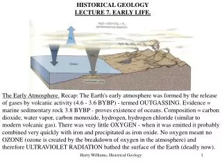
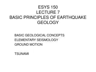
ESYS 150 LECTURE 7 BASIC PRINCIPLES OF EARTHQUAKE GEOLOGY. BASIC GEOLOGICAL CONCEPTS ELEMENTARY SEISMOLOGY GROUND MOTION TSUNAMI. BASIC GEOLOGICAL CONCEPTS EARTHQUAKE Caused by a fault. Fault is a fracture along which the earth moves.

E N D
ESYS 150LECTURE 7BASIC PRINCIPLES OF EARTHQUAKE GEOLOGY BASIC GEOLOGICAL CONCEPTS ELEMENTARY SEISMOLOGY GROUND MOTION TSUNAMI
BASIC GEOLOGICAL CONCEPTSEARTHQUAKECaused by a fault Fault is a fracture along which the earth moves. Offsets of tilled farmland by 1979 movement of the Imperial fault. View is to the east. West side of the fault has moved north.
BASIC GEOLOGICAL CONCEPTSFAULTS AND GEOLOGICAL MAPPINGThree Basic Principles (Steno 1669) Law of Original Horizontality - sediments are deposited or settle out of water in horizontal layers. Law of Superposition - in an un-deformed sequence of sedimentary rocks each successive layer is deposited on top of a previously formed, and hence older, layer. Law of Original Continuity - sediment layers are continuous ending only by butting up against a topographic high, pinching out or changing from one sediment type to another.
BASIC GEOLOGICALPRINCIPLESFAULTS AND GEOLOGICAL MAPPINGThe Grand Canyon Lowermost rocks are the oldest. Buried at great depths and altered by metamorphism, then exposed at surface by erosion. Younger marine sediments were deposited as layers, tilted and then eroded. Then the seas returned and horizontal layers were deposited. Finally whole region was uplifted and the Colorado river cut through to form gorge
GEOLGICAL CONCEPTSTYPES OF FAULTDescription of fault surface • A 75 My old exposed sandstone layer at La Jolla Bay exposed. The sea surface forms a horizontal plane against the inclined bed. • The strike of the bed is the angle the horizontal makes with north. The dip is the angle between the perpendicular to the strike and the bed
GEOLOGICAL CONCEPTSTYPES OF FAULTFootwall/Hanging wall from Mining geology Diagram showing miners excavating ore that precipitated in an old fault zone. Rock layers are not continuous across the fault. Miners put their lamps on the hanging wall and walked on the foot wall
GEOLOGICAL CONCEPTSTYPES OF FAULTNormal and Reverse faults Cross section of a normal fault. Hanging wall moved downwards. Zone of omission indicates extensional forces active Cross section of a reverse fault. Hanging wall has moved upwards. Zone of repetition indicates compressional forces active.
GEOLOGICAL CONCEPTSTYPES OF FAULTStrike-slip fault The right hand side of the fault moves towards the man when he straddles the fault. When he turns around the right hand side will still have moved closer to him. Called a right lateral fault
GEOLOGICAL CONCEPTSTYPES OF FAULTLeft stepping right lateral fault • A left step in a right lateral fault. The land is pushed together when the fault moves. Eventually could grow into a mountain. (b) Example shows land offset along the Superstition Hills right lateral fault during the 16 November 1987 earthquake.
GEOLOLOGICAL CONCEPTSTYPES OF FAULTRight stepping right lateral fault • The land is pulled apart at the fault bend whenever the fault moves. It creates a hole the could become a basin. • Land offset along Superstition Hills right lateral fault during the rupture. Note the right step and the pull apart at the bend.
GEOLOGICAL CONCEPTSTYPES OF FAULTFault surface Diagram of the fault surface. Hypocenter where rupture began: Epicenter point on Earth’s surface above the hypocenter. Due to dip of the fault, the epicenter does not plot on the trace of the fault at the surface.
SEISMOLOGYBASICSSeismometer The basic principles. The earth moves moving the framework of the seismometer. The suspended heavy weight and then pen beneath remain relatively stationary. As the concrete base moves the stationary pen draws an ink line on paper on the rotating drum.
SEISMOLOGYBASICSSeismogram Seismogram recorded on Russia of a 1909 earthquake in Asia Minor. Three types of wave are observed P (Primary), S (Secondary) and L (surface or Love) waves. Note the difference in time between the P and S waves.
SEISMOLOGYBASICSBody waves. Two types of waves move through the earth (Body waves) • P waves. Travel the fastest. Like the push-pull motion of a slinky toy. (Granite 4.8 km/sec) • S waves. Move in an up and down motion perpendicular to the direction of advance. Like the waves in a shaken rope. (Granite 3 km/sec)
SEISMOLOGYSEISMIC WAVESSurface waves Surface waves created when body waves hit the surface of the earth. They are similar to the waves created by throwing a rock into a lake. Consist of Love waves which are horizontally polarized and Raleigh waves which cause both vertical and horizontal movement. They travel slower than body waves but with less attenuation because of long wavelength and low frequency.
SEISMOLGYEARTHQUAKE LOCATIONTravel time versus distance plots Can construct distance versus travel time for earthquakes knowing properties of earth’s interior Note that with increasing distance the arrival times for the various waves separates. The 3 min 45 sec difference between the arrival time of the P and S waves corresponds to a distance of 2000 km.
SEISMOLOGYLOCATING EARTHQUAKESTriangulation Need three different seismic stations to locate an earthquake. Measure the P-S arrival times and convert these to distance. Triangulate using radius given by P-S travel times. Triangulation for position of an earthquake near New Madrid using stations in Columbus, St Louis and Memphis
SEISMOLOGYMAGNITUDEProperties of waves Important terms are Amplitude - height of wave above the starting point Wavelength - the distance between successive waves Period - the time between successive waves = 1/ Frequency Body waves - 0.5 to 20 Hz Surface waves - 0.005 to 0.1 Hz.
SEISMOLOGYMAGNITUDEScale Richer scale Based on the log to the base ten of the amplitudes of a standard seismometer 100 km from the earthquake center. For every ten fold increase in amplitude the Richter magnitude increases by one. However the energy release goes up by a much large factor Quick and easy to use
SEISMOLOGYMAGNITUDENomograph of the Richter scale Read the difference in travel time between P and S waves and plot. Read the maximum amplitude of the S wave and plot. Draw a line between the two points and gives the magnitude.
SEISMOLOGYMAGNITUDEEarthquakes in the world each year. Earth is shaken by millions of quakes each year. Most are too small to be felt. To be damaging most have to be above 6.0 Above 7 they can cause major damage. Note the decrease in frequency as the magnitude increases
SEISMOLOGYMAGNITUDEComparison of Earthquakes Comparison of Northridge, Loma Prieta, San Francisco and Sumatra 2004 earthquakes. Compute seismic moment and then convert to Moment Magnitude Moment is more reliable measure for large earthquakes as it measures directly the amount of strain energy released by movement along rupture surface.
GROUND MOTIONIMPORTANT CONCEPTSAcceleration and Resonance Buildings built to handle vertical forces such as weight but not horizontal forces. Acceleration compared to gravity 9.8 m/sec2 Acceleration - .1g weak buildings break up 1g nothing stands up Resonance - ground has natural frequency buildings have natural frequency 1 story .1s/ 30 story 3 secs / .1sec per story
GROUND MOTIONIMPORTANT CONCEPTSEarthquake Intensity Want quantitative method of measuring effect of earthquakes. Use descriptive Mercalli scale Major variables - Magnitude - Distance from hypocenter - Foundation materials/slopes - Building style - Duration of shaking
GROUND MOTIONEARTHQUAKE INTENSITYMercalli Scale Earthquake magnitude asses energy released by earthquakes. Earthquake intensity measures the effect on people and buildings Used to asses historical records
GROUND MOTIONEARTHQUAKE INTENSITYBuilding collapses Especially dangerous are buildings with “soft” first stories. (a) No bracing on the first floor and no shear walls. Stresses are concentrated at the joints between the between the first and second floors. They give way causing the floor to flatten. (b) Building on Washington Street in San Diego
GROUND MOTIONEARTHQUAKE INTENSITYBridges collapse Poorly designed bridges collapsed during 1994 Northridge earthquae due to vertical supports and horizontal roadbeds moving at different periods. If not bound together securely they separate and fall when shaken. Led to major retrofitting of all bridges in California. Strengthening columns and improving connections to the road way.
TSUNAMIHOW CREATED Biggest and most feared wave, harbor wave - Japanese Due to sub sea movements that disturb water mass, most often earthquakes. Analogous to throwing a stone into a pool, ripples - tsunami waves Period 10 - 60 min, Wavelength 100 - 800 km, amplitude 1 -2 m, velocity 230 m/sec (500 mph) At coast waves slow down and pile up and come on shore like a very rapidly rising tide.
TSUNAMINOTALBLE TSUNAMI IN RECENT TIMES Many tsunami’s in the Pacific. Mainly from sea bottom motion during earthquake. Velocity = √(g x D) where D is the depth of the ocean in meters. = 230 m/sec Moves quite slowly relative to P and S waves
TSUNAMIEARLY WARNING SYSTEM P, S and surface waves move at between 10 - 5.5 km/sec. Much faster than tsunami velocity of 230 m/sec. Body waves arrive much sooner than the tsunami waves. Have enough time to determine size and position of earthquake before the tsunami arrives.This is the basis of the early warning system.