Assessing Riparian Function
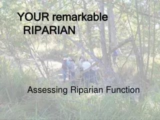
YOUR remarkable RIPARIAN. Assessing Riparian Function. What is possible?. 1981. 2000. Burro Creek AZ. What is possible?. Nueces River TX. What is possible?. Find out by bringing people together to listen to each other concerning the attributes and processes of riparian function.

Assessing Riparian Function
E N D
Presentation Transcript
YOUR remarkable RIPARIAN Assessing Riparian Function
What is possible? 1981 2000 Burro Creek AZ
What is possible? Nueces River TX
What is possible? Find out by bringing people together to listen to each other concerning the attributes and processes of riparian function
Objectives: • Present an overview of riparian-wetland function using PFC assessment approach and checklist • Define terms • Introduce hydrology attributes and processes
Riparian-wetland function creates what we all value Function is our common interest even if our values differ
Lesson we are all trying to learn – work with physical function, and not against it
Manage with physical processes in mind, and many riparian areas will heal themselves San Geronimo Cr TX May 2009
PFC Assessment • Focus initially on the physical function • Build understanding of the attributes & processes that help produce desired benefits and values • Identify attribute or process that is not in a working order • Develop management that allows physical processes to function
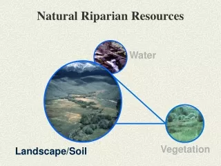
PFC Assessment Development • ID Team from the BLM, the FWS, and the NRCS with expertise in vegetation, hydrology, soils, and biology • Four year study period in the Western States (1988-92) • Collected soil, hydrology, and vegetation information at field sites • Identified common and important attributes/ processes that could be visually assessed
Proper Functioning Condition (PFC) • Term is used in two ways • Assessment process • Defined on the ground condition • How well the area’s physical processes are functioning • State of resiliency that will allow an area to hold together during moderately high flows, such as 5-, 10-, and 20-year events
Dissipate stream energy Reduce erosion Filter sediment Capture bedload Aid floodplain development Improve floodwater retention and groundwater recharge Develop root masses that stabilize stream banks Increased water quality and quantity Diverse ponding and channel characteristics Habitat for fish and wildlife Greater biodiversity PFC On-The-Ground Condition Adequate vegetation, landform or large woody material to: To Provide Physical Function Values
Potential The Natural vegetation Channel shape given little influence my humans Capability The • Vegetation • Channel shape with major influence by humans.
Perennial Potential Intermittent Ephemeral Interrupted Stream
Determining Potential • Relic areas (preserves, exclosures etc.) • Major landform(s) • Ecological site descriptions or classifications • Historic photos, survey notes, documents,and species lists • Hydrology information • Soil survey information • Expert knowledge (old timers, brilliant ecologists, experienced interdisciplinary team)
Functional - At Risk Riparian-Wetland Areas in Functional Condition (partially) However an existing attribute • Soil • Water • Vegetation Makes them susceptible to degradation during high-flow events like the 5-, 10-and 20- year events
Nonfunctioning Areas that are clearly not providing adequate vegetation, landform, or large woody material To: • Dissipate stream energy • Improve floodwater retention & groundwater recharge • Stabilize streambanks • And other characteristics common to PFC
YOUR remarkable RIPARIAN Proper Functioning Condition Lotic Checklist
Hydrology Items • Floodplain • Beaver Dams • Channel Characteristics • Riparian Area Expanding • Watershed Influence Erosion Deposition Hydrology Vegetation Values
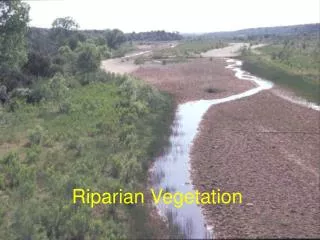
Item 1. Floodplain • Level area near a stream channel • Constructed by the stream • In the present climate • Flooded during moderate & high flow events • Should not be confused with terraces (abandoned floodplains) (adapted from Leopold 1994)
Item 1. Floodplain Why floodplain is important • Adjustment mechanism - additional capacity for the stream system to transport and store water and sediment • Provides energy dissipation • Periodic flooding to promote and sustain riparian vegetation • Periodic infiltration of floodwaters
Definition: Bankfull • Flow that just fills the channel • Point where water just begins to overflow onto a floodplain • 1.5 yr return interval is considered a reasonable average Verry et al. 2000
Why Bankfull is Important Discharge at/near bankfull stage is the discharge at which channel maintenance is most effective • Moving sediment • Forming or removing bars • Forming bends • Doing work that results in the average morphologic characteristics (shape) of channels Verry et al. 2000
Item 1. Floodplain inundated What is the effect on water table?
Item 1. Floodplain inundated What is the effect on water table?
Item 3. Channel Characteristics in balance • Sinuosity and Gradient
Sinuosity Sinuosity = Stream Length/ Valley Length 1.9 370’ 195’
Slope or Gradient Elevation at Elevation at upper end lower end % Mean Slope = Stream channel length * 100
Item 3. Channel Characteristics in balance Width/Depth Ratio
Wbkf Dmean Width / Depth Ratio
Item 3. Channel Characteristics in balance Width/Depth Ratio
Item 4. Riparian Area Expanding Nueces River, TX Oct 2009
Item 4. Riparian Area Expanding Nueces River, TX Oct 2009
Item 5. Watershed Influence Energy Use & Transformation Variables • Discharge • Sediment Quantity • Velocity • Depth • Roughness • Width • Particle Size • Slope Interaction results in transportation and deposition of sediment, channel properties, in-channel features such as bars, pattern, etc.,
Item 5. Watershed Influence Mimbres R NM
Hydrology Items • Floodplain • Beaver Dams • Channel Characteristics • Riparian Area Expanding • Watershed Influence Erosion Deposition Hydrology Vegetation Values
Next Up = Riparian-wetland vegetation information