HydroView: An Infrastructure Program for Hydrologic Science
210 likes | 327 Vues
HydroView is a transformative infrastructure program led by CUAHSI, aimed at advancing hydrologic science through community engagement and collaboration among 88 research universities. Established in 2001, CUAHSI supports hydrologic research by identifying community needs, managing observational networks, and facilitating interdisciplinary projects. Key components include observatories, advanced instrumentation, and informatics, fostering data sharing and scientific discovery. The program encourages innovative research across hydrologic and biogeochemical cycles, with an emphasis on sustainability and robust data management strategies.

HydroView: An Infrastructure Program for Hydrologic Science
E N D
Presentation Transcript
HydroView: An Infrastructure Program for Hydrologic Science Jon Duncan, Communications DirectorConsortium of Universities for the Advancement of Hydrologic Sciences, Inc.
Who is CUAHSI? • A consortium of 88 research universities and 1 affiliate member • Incorporated June, 2001 as a non-profit corporation in Washington, DC
What does CUAHSI do? • Serve hydrologic science community • Develop community goals • Identify needs • Advise NSF • Operate community programs • Manage infrastructure • Develop program ideas
HydroView • Initial program • Mutually supportive elements • Observatories • Instrumentation • Informatics • Synthesis
Current Status • Synthesis: SoI under review; proposal to be submitted Fall, 2004. • Informatics: Pilot program begun with $2.5M, 2-year grant • Instrumentation: Proposal about to be submitted for 3-yr pilot • Observatories: Pilot 5-station network to be started in 2005
Today’s Briefing • Focus on HO’s • Design concepts • Next steps in implementation • Management questions
Design Concepts for HO’s • Community Resource • Core data available to all through common interface • Equal access to site • Support for remote investigators • Sufficiently Large • Explore all interfaces, include LS/Atm • Contribute to hydrologic improvement in GCM’s • National-scale Network • Comparable data across observatories • Test hypotheses in different hydrologic settings
Science Topics • Linking Hydrologic and Biogeochemical Cycles • Hydrologic Extremes • Sustainability of Water Resources • Transport of Chemical and Biological Contaminants • Hydrologic Influence on Ecosystem Functions
Cross-cutting Themes • Scaling • Forcing, Feedbacks, and Coupling • Predictions and Limits-to-Prediction
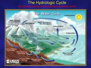
Hydrologic Characterization Three fundamental properties • Fluxes between “stores” • Residence time within “stores” • Flowpaths among “stores” Stores include surface, subsurface and atmosphere.
Core Data • Provides estimates of fundamental characteristics • Common to multiple hypotheses • Immediately available to community
HO Development • Local perspective • Design data necessary to address chosen hypotheses • Designate “core” data and “first-publication” data • Network perspective • Provides common data model • Determines metadata standards • Influences core data collection
Observatory Design Team • Determines best way to “characterize” site • Delineates “core data” boundary • Develops workplan for data collection • HO Standing Committee reviews plan
HO Professional Staff • Implements workplan developed by observatory design team (ODT) • Populates common data model • Provides site management to coordinate research by ODT and others • Collects non-core data as resources permit
Evaluation Criteria—1 • Hypotheses Posed • Meet at least 3 of 5 topics • Interdisciplinary • Innovative • Design • Provides characteristics across range of scales, including largest • Combination of nested, intensive basins with broader surveys
Evaluation Criteria—2 • Leveraging of Existing Data • Intensive studies (LTER, USGS, ARS, USFS) • Monitoring data sets (Federal, state and local) • Institutional support • State/Local support • Stakeholder organizations • Educational/Outreach Opportunities
Two Perspectives • Local Design Team • Choose hypotheses • Rewarded by pursuing “their” science • Just one research team—do not control site • Broader Community • Site must attract non-local scientists • Broad range of disciplines
Next Steps • Aug. 1, 2004: 10-page prospectus • Aug. 23, 2004: National Workshop • Fall, 2004: Regional Workshops • Jan, 2005: NSF Program Announcement • Apr, 2005: Proposals Due • Sep/Oct 2005: Award 2 HO’s • 2008: Competition for 3rd HO
National Workshop • Choose 5 “example” basins for hypothetical HO Network from submitted prospectuses • Day 1 • AM: HIS, Neuse, HMF presentations • PM: Poster session and election • Day 2: Breakout groups by basin (core data composition) and by science topic (cross-observatory hypothesis testing) • Selection of basins has no meaning beyond workshop
Regional Workshops • Held Sep – Dec, 2004 • CUAHSI creates 5 hydrologic regions • Open to everyone (including non-hydrologists!) • Objectives • Build community support • Learn about potential sites in region • Support level: $20K/wkshp
HO Management • “2 PI” model • Ensures ODT does not control site • Divides community responsibility from individual science endeavor • Site director? • 1 PI Model • Integrates ODT and Site Director • Integral science model