Understanding Plate Tectonics: The Dynamic Earth and Its Features
The plate tectonic theory reveals the Earth's surface is shaped by the movement of tectonic plates. Emerging from Alfred Wegener's hypothesis of continental drift in the early 20th century, this theory explains how mountains form from plate collisions and the distribution of fossils across continents. There are three types of plate boundaries: transform, divergent, and convergent, each linked with various geological phenomena like earthquakes and volcanoes. This ever-evolving process demonstrates the constant dynamism of our planet's crust.


Understanding Plate Tectonics: The Dynamic Earth and Its Features
E N D
Presentation Transcript
Plate tectonics By Sophie Protheroe
Theory • In the late 19th and early 20th centuries, geologists assumed that the Earth's major features were fixed. It was thought that mountains formed because the Earth was cooling down, and in doing so contracted. This was believed to form wrinkles, or mountains, in the Earth's crust. If the idea was correct, however, mountains would be spread evenly over the Earth's surface. We know this is not the case. • In the 1960’s, the plate tectonic theory was formed. • The plate tectonic theory arose out of the hypothesis of continental drift. • This was proposed by Alfred Wegener in 1912and expanded in his 1915 book ‘The Origin of Continents and Oceans’. He suggested that the present continents once formed a single land mass that drifted apart. • Wegener suggested that mountains were formed when the edge of a drifting continent collided with another, causing it to crumple and fold. For example, the Himalayas were formed when India came into contact with Asia.
Evidence Wegener’s evidence for continental drift was that: • The same types of fossilised animals and plants are found in South America and Africa. • The shape of the east coast of South America fits the west coast of Africa, like pieces in a jigsaw puzzle. • Matching rock formations and mountain chains are found in South America and Africa. • In the 1950s, evidence from magnetism in the ocean floor showed that the seafloors were spreading by a few centimetres each year. This showed movement of large parts of the Earth’s crust, now called tectonic plates.
Types of plate boundaries Three types of plate boundaries exist, characterized by the way the plates move relative to each other. They are associated with different types of surface phenomena. The different types of plate boundaries are: * Transform boundaries occur where plates slide or, perhaps more accurately, grind past each other along transform faults. The relative motion of the two plates is either sinistral (left side toward the observer) or dextral (right side toward the observer). The San Andreas Fault in California is an example of a transform boundary exhibiting dextral motion. * Divergent boundaries occur where two plates slide apart from each other. Mid-ocean ridges (e.g., Mid-Atlantic Ridge) and active zones of rifting (such as Africa's Great Rift Valley) are both examples of divergent boundaries. * Convergent boundaries (or active margins) occur where two plates slide towards each other commonly forming either a subduction zone (if one plate moves underneath the other) or a continental collision (if the two plates contain continental crust). Deep marine trenches are typically associated with subduction zones. The subducting slab contains many hydrous minerals, which release their water on heating; this water then causes the mantle to melt, producing volcanism. Examples of this are the Andes mountain range in South America and the Japanese island arc.
Volcanoes • Volcanoes form when magma reaches the Earth's surface, causing eruptions of lava and ash. They occur at destructive (compressional) and constructive (tensional) plate boundaries. • The immediate effects of volcanic eruptions can be devastating, but they may be beneficial in the long term. How volcanoes form… 1) Magma rises through cracks or weaknesses in the Earth's crust. 2) Pressure builds up inside the Earth. 3) When this pressure is released, eg as a result of plate movement, magma explodes to the surface causing a volcanic eruption. 4) The lava from the eruption cools to form new crust. 5) Over time, after several eruptions, the rock builds up and a volcano forms
Shield Volcanoes • The characteristics of a shield volcano • Shield volcanoes are usually found at constructive or tensional boundaries. • They are low, with gently sloping sides. • They are formed by eruptions of thin, runny lava. • Eruptions tend to be frequent but relatively gentle.
Composite volcanoes • Composite volcanoes are made up of alternating layers of lava and ash (other volcanoes just consist of lava). • They are usually found at destructive or compressional boundaries. • The eruptions from these volcanoes may be a pyroclastic flow rather than a lava flow. A pyroclastic flow is a mixture of hot steam, ash, rock and dust. • A pyroclastic flow can roll down the sides of a volcano at very high speeds and with temperatures of over 400° C.
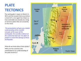
Earthquakes • Earthquakes are caused by the release of built-up pressure inside the Earth's crust. An earthquake's power is measured on the Richter scale using an instrument called a seismometer. • The effects of an earthquake can be devastating - they can destroy settlements, change landscapes, and cause many deaths. Causes… • An earthquake is the shaking and vibration of the Earth's crust due to movement of the Earth's plates (plate tectonics). Earthquakes can happen along any type of plate boundary. • Earthquakes occur when tension is released from inside the crust. Plates do not always move smoothly alongside each other and sometimes get stuck. When this happens pressure builds up. When this pressure is eventually released, an earthquake tends to occur.
The epicentre of an earthquake • The point inside the crust where the pressure is released is called the focus. The point on the Earth's surface above the focus is called the epicentre. • Earthquake energy is released in seismic waves. These waves spread out from the focus. The waves are felt most strongly at the epicentre, becoming less strong as they travel further away. The most severe damage caused by an earthquake will happen close to the epicentre.