Download
1 / 2
20 likes | 209 Vues
Tropical Cyclone Quick Reference Guide 2010. Naval Maritime Forecast Center - Norfolk, 9141 Third Ave, Norfolk VA 23511-2394. Operations Watch Floor: 757 - 444 - 7750 DSN 564 -7750. email: maritime.cdo@navy.mil || cdo.nmfa_n.001.fct@navy.smil.mil.

E N D
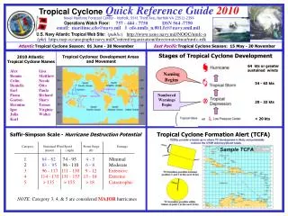
Tropical CycloneQuick Reference Guide2010 Naval Maritime Forecast Center - Norfolk, 9141 Third Ave, Norfolk VA 23511-2394 Operations Watch Floor:757 - 444 - 7750 DSN 564 -7750 email: maritime.cdo@navy.mil || cdo.nmfa_n.001.fct@navy.smil.mil U.S. Navy Atlantic Tropical Web Site: (public) http://www.usno.navy.mil/NOOC/nmfc-n (pki)https:nop.oceanography.navy.mil/Content/organization/directorates/mar/nmfc-nfk Atlantic Tropical Cyclone Season: 01 June - 30 November East Pacific Tropical Cyclone Season: 15 May - 30 November Stages of Tropical Cyclone Development Tropical Cyclones: Development Areas and Movement 2010 Atlantic Tropical Cyclone Names 64 kts or greater sustained winds Alex Bonnie ColinDanielleEarl Fiona GastonHermine Igor Julia Karl Lisa Matthew NicoleOttoPaula Richard Shary Tomas Virginie Walter Naming Begins 34 - 63 kts Numbered Warnings Begin 20 - 33 kts or < 20 kts Tropical Cyclone Formation Alert (TCFA) Saffir-Simpson Scale - Hurricane Destruction Potential Category Sustained Wind Speed Storm Surge Damage (knots) ( mph) (ft) 1 64 - 82 74 - 95 4 - 5 Minimal2 83 - 95 96 - 110 6 - 8 Moderate 396 - 113 111 - 1309 - 12 Extensive 4114 - 135 131 - 15513 - 18Extreme 5> 135 > 155> 18Catastrophic NOTE: Category 3, 4, & 5 are consideredMAJOR hurricanes
Tropical CycloneQuick Reference Guide2010 Naval Maritime Forecast Center - Norfolk, 9141 Third Ave, Norfolk VA 23511-2394 Operations Watch Floor:757 – 444 - 7750DSN 564 - 7750 email: maritime.cdo@navy.mil cdo.nmfa_n.001.fct@navy.smil.mil Tropical Cyclone Conditions of Readiness (COR) (time to onset of destructive winds*) Aircraft Evacuation Status Reports (required at the following times) Sortie Conditions COR V 96 hours COR IV 72 hours COR III 48 hours COR II 24 hours COR I 12 hours Charlie - Prepare to sortie within 48 hours Bravo - Expected sortie within 24 hours Alpha - Commence sortie to sea 72 hours 48 hours 24 hours 12 hours * Destructive winds are defined as sustained 50 kts or greater KEY TO TROPICAL CYCLONE WARNING GRAPHICS Environmental Requirements for Tropical Cyclone Development The black and red lines around a projected tropical cyclone track indicate the 34 knot, 50 knot, and 64 knot wind radii associated with the storm at a given point. The outermost black line indicates the 34 knot radius, the red line indicates the 50 knot radius, and the inner black line shows the 64 knot radius. Since not all cyclones have the highest winds associated with them, weaker storms will not have a 64-knot radius (and possibly no 50-knot radius also.) The actual number of miles for the radius in each quadrant is listed in the associated Tropical Cyclone Message. • Sea Surface Temperature> 26 C/ 78 F with sufficient depth (approx 200ft) of warm water • Pre-existing disturbance to trigger thunderstorm activity (frontal boundary, easterly wave, distal low pressure, etc…) • Divergence at the Upper Levels (above the 400 mb level) • Ample Planetary Vorticity (Coriolis Force) [disturbance located above 8 degrees North Latitude or below 8 degrees South Latitude] • Weak (< 20kts) vertical wind shear between the surface and upper troposphere • Relatively moist layers at the mid-levels (about the 700mb level / 10,000 ft) • System embedded in a potentially unstable air mass NFAAS standardizes a method for the Navy to account, assess, manage, and monitor the recovery process for personnel and their families affected and/or scattered by a wide-spread catastrophic event. The NFAAS provides valuable information to all levels of the Navy chain of command, allowing commanders to make strategic decisions which facilitate a return to stability. • NFAAS allows Navy Personnel to do the following: • Update Contact/Location information • Complete Needs Assessment • View Reference Information NFAAS Website --- https://www.navyfamily.navy.mil