Download
1 / 57
570 likes | 797 Vues
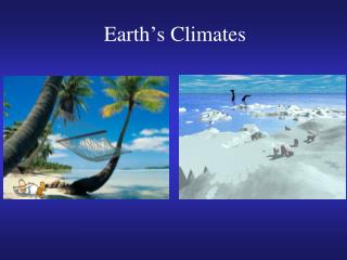
Climates of the Earth. Chapter 3. Seasons. Solstice: Marks the longest or shortest day of the year. Winter solstice: December Summer Solstice: June. Seasons. Equinox: Even days of sunlight and darkness . Fall: September Spring: March. Weather.

E N D
Climates of the Earth Chapter 3
Seasons • Solstice:Marks the longest or shortest day of the year. • Winter solstice: December • Summer Solstice: June
Seasons • Equinox: Even days of sunlight and darkness. • Fall: September • Spring: March
Weather • The condition of the atmosphere at a particular place and time.
Climate • Weather in a particular location over a long period of time.
Precipitation: falling water droplets in the form of rain, sleet, or snow. • Convectional: In hot climates morning sunshine heats warm moist air. Clouds form in the afternoon and rain falls.
Orographic • Associated with mountain areas. Storms drop more rain on the windward side of a mountain and less on the leeward side, creating a rain shadow.
Frontal • Mid-latitude frontal storms-cold dense air masses that push lighter warm air upwards, causing precipitation to form.
Rain Shadow • A dry area that receives very little precipitation from the descending dry air on the leeward side of a mountain range.
Weather Extremes • Blizzards: a heavy snowstorm with high winds and reduced visibility.
Droughts • A long period of time with little or no rain that can lead to crop failures, reduced water levels, and possible dust storms.
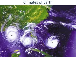
Hurricanes • Form in late summer to early Fall over tropical waters off the coast of Africa. • Also form off of the western coast of Mexico. • Normally track towards the eastern United States.
Typhoons • Form in the Pacific Ocean between the International Date Line and the coasts of Asia or Australia.
Cyclones • Form in the Indian Ocean and normally track towards South Asia.
Characteristics of all three storms: • High winds, thunderstorms, heavy rain, and storm surges. • Large air mass storms. • Normally born in tropical latitudes and move towards mid-latitudes, feeding off of the ocean’s energy. (moisture and heat) • 74 mph minimum
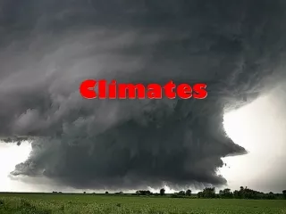
Tornado • Spawned by severe thunderstorms across the central U.S. when cold and warm air masses collide. • When a huge storm, towering in the atmosphere is sheared at the top by winds it can create a spinning motion in the system. A funnel shaped cloud drops from the main storm cloud and destructive winds in excess of 100 mph can be generated.
The Fujita scale measures the destructive potential of these storms. • The most violent of all storms.
F0 Gale tornado 40-72 mph Some damage to chimneys; breaks branches off trees; pushes over shallow-rooted trees; damages sign boards.
F1 Moderate tornado 73-112 mph • The lower limit is the beginning of hurricane wind speed; peels surface off roofs; mobile homes pushed off foundations or overturned; moving autos pushed off the roads; attached garages may be destroyed.
F2 Significant tornado 113-157 mph • Considerable damage. Roofs torn off frame houses; mobile homes demolished; boxcars pushed over; large trees snapped or uprooted; light object missiles generated.
F3 Severe tornado 158-206 mph • Roof and some walls torn off well constructed houses; trains overturned; most trees in forest uprooted
F4 Devastating tornado 207-260 mph • Well-constructed houses leveled; structures with weak foundations blown off some distance; cars thrown and large missiles generated
F5 Incredible tornado 261-318 mph • Strong frame houses lifted off foundations and carried considerable distances to disintegrate; automobile sized missiles fly through the air in excess of 100 meters; trees debarked; steel reinforced concrete structures badly damaged.
Tornado Season • February: Southern Gulf states-peaking in April and May. • June July and August-Tornado Alley: Oklahoma, Kansas, et. al.
Monsoons • Seasonal Shifts in wind patterns affecting parts of South Asia and SE Asia. • From November to April the prevailing winds blow from the land, therefore they are dry.
From May to October the prevailing winds blow from the ocean, therefore they are wet. • During the wet season the rains are persistent and often torrential, leading to flooding and other related problems, but this is a boon to the rice farmers.
Factors Affecting Climate • Wind currents help to distribute the world’s heat energy through convection. • Convection: the transfer of heat in the atmosphere by upward motion of the air. • Which wind currents affect our climate? westerly's • Ocean Currents: Hot or Cold?
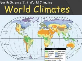
Zones of Latitude: • Low or Tropical Latitudes are found on either side of the equator. They extend to the Tropic of Cancer in the North to the Tropic of Capricorn in the South. Lands here are hot all year.
Zones of Latitude: • High or Polar Latitudes are found encircling the North and South Pole. They are cold all year and the boundaries are defined by the Arctic and Antarctic circles.
Zones of Latitude: • The Middle or Temperate Latitudes are located within the Tropic and Polar regions. They generally have warm summers and cold winters
Elevation: As elevation increases temperature decreases • Topography: See Orographic Effect.
Changes in Climate • El Nino:See the skill builder on page 57. • An abnormal winter warming of the mid-latitude waters in the Pacific Ocean can cause extreme imbalances in weather patterns. • For example: Places that are normally wet suffer sever drought and places that are normally dry suffer heavy rain and flooding.
Global Warming • This is the theory that the temperature of the earth is increasing at an alarming rate. This may increase the level of the oceans, causing coastal flooding and lead to greater tropical storms.
Greenhouse Effect • This may be one of the factors causing global warming. Co2 pollution in the atmosphere is trapping the sun’s energy and causing the polar ice caps to melt.
Climate Definitions • Tropical: Yearly average temperature of 80 degrees and daily rainfall. Many rain forests are located in this area surrounded by tropical grasslands.
Arid/Semi-Arid • Dry or nearly dry climates receive little rainfall. Scrub grasses and bushes predominate.
Deserts: • Next to no rainfall. • They can be extremely hot during the day and very cold at night. • Cold deserts can be found in the mid-latitudes in mountain rain shadows.
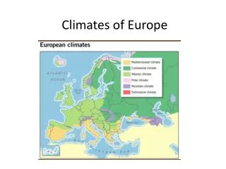
Mediterranean: • Named for the climate around the Mediterranean Sea, but can also be found in Southern California. • Warm, dry Summers • Cool, rainy Winters
Marine: • Marine means ocean and that is what affects these climates the most. • Cool and rainy year round • British Isles • Seattle, Washington
Humid Subtropical • Found on the east coast of continents. • Long, hot, and humid Summers. • Winters are relatively mild. • Subject to hurricanes.
Humid Continental • Humid indicates that there is sufficient rainfall, but continental indicates that this climate is more affected by the land and therefore cooler. • Winters are longer and colder.
Subarctic: • Evergreen forests called Taiga cover most of the region. • Winters are very cold. • Summers are short and cool.
Tundra: • Flat treeless lands that form a ring around the Arctic Circle. • The land has permafrost: the subsoil is permanently frozen.
Permafrost: • See previous slide.
Ice Cap • Snow, ice and permanently freezing temperatures. • Found at the poles and high in Mountain ranges. • Think Alps or Mt. Everest
Highlands • A Highlands climate can vary with altitude, latitude, and continental location. • Ex: Andes Mountains in South America.
Soil and Vegetation • Ecosystem: an interdependent community of plants and animals.