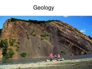
Coastal Geology
310 likes | 914 Vues
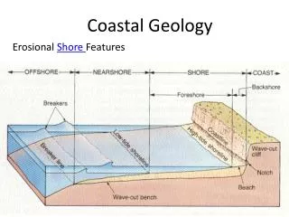
Coastal Geology. Erosional Shore Features. Erosional Shore Features. Shore = the zone that lies between low tide and the highest elevation that is affected by storm waves. . Coast = the zone from the highest elevation of the shore inland as far as

Coastal Geology
E N D
Presentation Transcript
Coastal Geology ErosionalShore Features
Erosional Shore Features Shore = the zone that lies between low tide and the highest elevation that is affected by storm waves. Coast = the zone from the highest elevation of the shore inland as far as features that seem to be related to marine processes occur. Flooding and high winds are examples. Coastline = The dividing line between the shore and the coast. It’s a line connecting the highest points affected by storm waves. The shore is divided into…. • Foreshore = is exposed at low tide and • submerged at high tide. • Backshore = extends from the normal high tide to the • coastline.
Wave cut bench = smooth area cut into bedrock by wave erosion. Beach = deposits that move along the wave cut bench. Wave cut cliff = a cliff formed by wave action cutting away a notch at its base.
Longshore current = a movement of water that is the result of waves striking the shore at an angle. Swash = water moving sediment onto the exposed beach at an angle. Backwash = gravity carrying the water and sediment of the swash straight down the beach. Longshore drift = the movement of sediment by the longshore current.
The amount of longshore drift is determined by an equilibrium between erosional and depositional forces. Any interference will destroy this equilibrium. Examples of such interferences are as follows. Breakwater The purpose of the breakwater is to prevent waves from entering into a harbor. It causes the area down current to erode at an increased rate.
Jetties and Groins Jetties are built to keep a harbor open. Jetties cause the area down current to erode at an increased rate, and the area up current to receive increased deposition. Groins are built to impede the longshore-drift, resulting in increase deposition. Groins are much shorter than jetties and eventually allow sand to migrate around their ends and re-enter the longshore drift before excessive erosion occurs.
Seawall The seawalls purpose is to protect structures from storm waves. It actually increases the rate of erosion by concentrating the force of the waves (energy) at the base of the seawall. The end result is that the seawall falls into the ocean along with the property it was designed to protect!
Special Geomorphic Features Spit = A linear ridge of sediment attached at one end to land. A spit is an extension of a beach into deeper water near the mouth of a bay. Spits curve into the bay Bay Barrier = If the spit extends across the bay to the mainland, then it is a bay barrier. Tombolo = a sand ridge that connects an island to another island or a mainland. Barrier Island = deposits of sand that lay parallel to the coast.
The typical barrier island has the following characteristics: Ocean beach = the beach on the ocean side of a barrier island. Dune = a hill of sand created when winds blow sand inland during dry periods. It is stabilized by dune grasses. It is the estuaries’ primary protection against flooding. Barrier flat = located behind the dunes. Forms from the deposition of sand driven through passes during storms. Typically colonized by grasses. If frequency of flooding decreases thickets, woodlands, and forests may move in. Salt marsh = located behind the barrier flat. Affected by the ebb and flow of the salt water. A difficult environment for non-adapted plants or animals to survive in.
New marsh is formed as overwash (flooding) carries sediment into the lagoon. Because of a gradual rise in sea level, barrier islands are migrating landward.