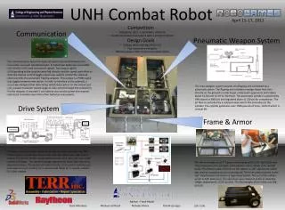
Advanced Multi-Robot Navigation and Mapping for Combat Environments
This project presents a proof of concept for military applications, focusing on autonomous robots that can navigate and map combat environments while detecting potential threats. Using the Pioneer 3D-X platform equipped with sonar and metal detectors, robots are designed to autonomously guide supply caravans or troops safely through hazardous zones. The project summarizes subsystem development, including pathfinding, environmental mapping, and obstacle detection through advanced algorithms and sensors. Work progress and a detailed schedule of tasks are also provided, aiming to enhance operational effectiveness in unknown terrains.

Advanced Multi-Robot Navigation and Mapping for Combat Environments
E N D
Presentation Transcript
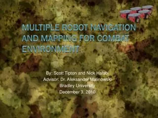
By: Scott Tipton and Nick Halabi Advisor: Dr. Aleksander Malinowski Bradley University December 3, 2010 Multiple Robot navigation and Mapping for Combat environment
Outline • Project Summary • Previous Work • Project Description • System Overview • Subsystems • Work completed and important equations • Equipment and Parts List • Progress • Schedule of Tasks
Project Summary • Military application – proof of concept • Combat/unknown environment • Indoor or outdoor • Map area and detect potential threats • Guide autonomous supply caravans or troops safely through a combat zone
System Platform • Pioneer 3D-X • 8 Sonar sensors (+90 to -90) • 2 wheels for navigation, 1 for stability • Navigation Computer (Laptop) • C++ program with Visual Studio 2005 • Aria • MobileSim
Goals • Robot Navigating • Sonar Sensors • IR Sensors • Environment Mapping • Metal Detector • Path Finding • Server Infrastructure • Localization
Previous Work • IR sensors integration • Dr. Malinowski’s mapping program • Updated by John Hessling
Project Description • First robot scans and maps environment • Second robot uses path finding algorithm to designate safe route • Server/Central command • Pass information (map files) • User override via joystick
Subsystems – Mode 1 • Find closest wall and drive to it • Use wall following algorithm • Perform random movement when finished to scan interior • Optional operator override • Map environment • Detect threats with metal detectors • Relay map to server
Mode 1 – Equations • Wall distance • (a*b*sin(20/rad_to_deg))/sqrt(a^2*+b^2-2*a*b*cos(20/rad_to_deg)) • (a*b*sin(20/rad_to_deg))/c • Move parallel to wall • angle = asin(height/a)*rad_to_deg +10 • angle = 180 - angle; • Wall following • error = (((xr90 + ideal_distance)/2)-xr90)
Subsystems – Server • Maintain constant connection with both robots • Receive and update map from mode 1 • Relay map to mode 2 • User override with joystick control
Subsystems - Mode 2 • Read map from server • Path Planning - determine safest route • Navigate to destination
Mode 2 – Path Planning • Grassfire approach • Obstacles – 32,000 • Non-reachable – 0
Equipment and Parts List • Pioneer 3D-X • Metal detectors – Electronics123.comProduct # Velleman K7102 • IR sensors - Sharp GP2Y0A02YK0F • Force Feedback Joystick • Silicon Labs 80C51F120 + UART/USB adaptor
Velleman Metal Detectors • Kit- Requires Soldering • Metal detecting distance adjustable: up to 3.15" • We will use 4 detectors on the mapping robot • This will be a proof of concept, to see if we can detect mines
Progress • Mode 1 – 70% Complete • Mapping and navigation • Manual override with joystick • Metal Detector • Improve wall following • Mode 2 – 50% • Path planning using the grassfire approach • Possibly use the potential field approach or a combination of the two • Server – 0%
Schedule of Tasks 12/17/2009 – 1/20/2010 • Improve wall following algorithm • Develop potential field path planning • Start server setup • Setup testing environments 1/21/2010 – 2/11/2010 • Continue server work • Begin integrating metal detector sensors and possible IR sensors 2/18/2010 – 3/11/2010 • Work with Mike Firman • Implement force feedback joysticks • Localization if time permits. 3/13/2010 – 3/22/2010 • Spring break • Begin final presentation • Conference paper