Download
1 / 53
540 likes | 670 Vues
IMPACT ASSESSMENT OF BUILT ENVIRONMENT ON PEDESTRIAN ACCIDENTS. By K.R. Vinodh Kumar, Dr. Nisha Radhakrishnan* Dr. Samson Mathew** Department of Civil Engineering National Institute of Technology Trichy, India. National Institute of Technology Tiruchirappalli, INDIA. Introduction.

E N D
IMPACT ASSESSMENT OF BUILT ENVIRONMENT ON PEDESTRIAN ACCIDENTS By K.R. Vinodh Kumar, Dr. Nisha Radhakrishnan* Dr. Samson Mathew** Department of Civil Engineering National Institute of Technology Trichy, India.
Introduction • WHO reported that over 1.2 million people die each year on the world’s roads and 50 million suffer non-fatal injuries. • It also predicted that road traffic injuries will rise to become the 5th leading cause of death by 2030. • Pedestrians, cyclists, drivers of motorized Two – wheelers and their passengers account for almost half of global road traffic deaths.
Causes of Death Introduction
Death vs Age • Road Traffic injuries are one of the top three causes of death for people aged between 5 and 44 years.
Pedestrian Safety??? • Pedestrians share a high percentage in road user fatalities. • They are exposed to severe consequences of road accidents than other road users. • Pedestrian safety is often an afterthought. • Road facilities in urban areas are still an important source of harm to pedestrians.
Interventions • Education and enforcement cannot be the only measures taken to reach a sustainable road safety. • Local Environment and road infrastructure play a substantial role in the co-occurrence of road accidents.
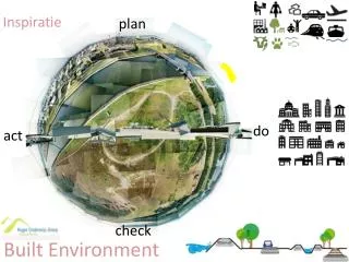
Built Environment (BE) • Built Environment refers to the structures, and infrastructure, that are made by man. • Transportation Built Environment - includes road infrastructure, pedestrian infrastructure and streetscape like crosswalk, pedestrian signals, median, refuge island etc which has its influence on the pedestrian activity.
Examples of BE Reducing Accidents Crosswalk lighting & signal Road narrowing Refuge island
Examples of BE Causing Accidents Flora Obstruction Curb parking
Examples of BE Examples of BE Causing Accidents Midblock with no crosswalks, traffic calming measures Long walking distance – Absence of Median/Refuge island
Indian Scenario – Road Accidents • A total of 4,30,654‘Road Accidents’ reported during the year 2010. • These accidents caused 1,33,938 deaths. • 5.5% increase in Accidental Deaths. • Tamil Nadu, Andhra Pradesh and Maharashtra have accounted for 11.5%, 10.5% and 7.1% respectively of total ‘Road Accident’ deaths. Source : National Crime Records Bureau
Indian Scenario – Pedestrian Safety • Pedestrians are more exposed to accident fatalities caused by the motor vehicles than any other means. • Studies have been done relating the factors like Traffic volume, speed, etc., with the pedestrian accidents – ignoring other factors especially BE elements. • Measures to identify and rectify those factors prove to be difficult or very expensive in the field by means of ITS implementation and monitoring.
Objectives • To study the impact/influence of Built Environment on Pedestrian safety. • To collect pedestrian accident data and to map the accident spot in Tiruchirappalli city base map. • To identify location of high density pedestrian crashes using spatial analysis technique. • To conduct Built Environment Audit along the identified hotspots. • To analyse the influence of the each Built Environment elements on Pedestrian accident occurrences by Logistic Regression modelling.
Study Area Study Area INDIA TAMILNADU Source: Tiruchirappalli city corporation
Methodology Identification of Modifiable BE elements Accident Data collection Preparation of BE Audit Data Sheet Filtering Pedestrian Accidents & Data analysis Conducting BE Audit Geo-coding all the accident spots Land use classification of Hotspots Spatial Analysis of Accident spots Developing a statistical model Suggestions for improvements
Mode Wise Distribution of Fatalities in Trichy City (2009 - 2011) Source : Traffic Control Room, Trichy
Mode Wise Percentage of Pedestrian Accidents (2009 – 2011) Source : Traffic Control Room, Trichy
Accident Spot location • Besides identifying locations of pedestrian crashes, detecting the high-density zones, which refers to the number of pedestrian crashes per unit of road segment, is critical for an intervention program. • Although pedestrian safety in a motorized urban environment is important throughout a city, public health interventions prioritized at these high density zones are paramount to make accident reduction efforts more effective • Creation of Density map is essential to identify critical zones. Accident Spots
Density analysis and density Map • Density surfaces show where point or line features are concentrated. For Example Cell Values of Population Density
Kernel Density • Determine if points (events) are exhibiting specific pattern over study area or are they randomly distributed. • Estimate the intensity (density) of how the point pattern distributed over the study area. • Intensity = Mean number of events per unit area at points defined as the limit. • Search radius of 150m was adopted for the analysis.
Kernel Density Map TV koil Toyota showroom Puthur 4 road Gandhi market Ariyamangalam Airport
Spatial Autocorrelation • This tool measures spatial autocorrelation (feature similarity) based on both feature locations and feature values simultaneously. • It evaluates whether the pattern expressed is clustered, dispersed, or random. • The tool calculates the Moran's I Index value and a Z score evaluating the significance of the index value.
Moran’s I Index • Moran's Index value near +1.0 indicates clustering while an index value near -1.0 indicates dispersion. - 1.0 0 + 1.0
List of Identified Hot Spots List of Identified Hot Spots • Ariyamangalam - SIT Bus stop • Ariyamangalam - Rice mill Bus stop • Ariyamangalam - Rail Nagar Bus stop • Airport - J K Nagar intersection • Airport – Wireless Rd • Pudhukottai Rd – Ponmalaipati Rd intersection • TVS Tollgate intersection • Rockins – Mc Donalds Road intersection • Rockins – Melapudur Rd intersection • Rockins – HPO Rd intersection 11. Lawson – Bharathidasan road intersection 12. Reynolds – Lawson road intersection 13. Puthur 4 road intersection 14. Gandhi market – Big bazaar street intersection 15. Chatram Bus stand intersection 16. Chennai bypass – Kallanai road intersection 17. Chennai bypass – Kodayampettai intersection 18. T V Koil intersection 19. Chennai trunk road – Kollidam intersection
List of Built Environment Elements Considered Curb Parking Crosswalk Lighting Bus Stops Pedestrian Signals Flora Obstruction Speed Humps Road Width Sidewalk Median Refuge Island Instruction Signs Advance Stop lines Pedestrian Barriers Branding Signs Alcohol Serving Establishments Educational Institutions Industrial areas Commercial areas Residential areas
Hotspot Linear Buffering 30m Linear Buffer Pedestrian Accidents
Logistic Regression in SPSS 20 • Used to analyze relationships between a dichotomous dependent variable and metric or dichotomous independent variables. • Combines the independent variables to estimate the probability that a particular event will occur or not. • Finds the impact of each independent variable on dependent variable.
Independent Variables Continuous • Educational areas • Public areas • Commercial areas • Residential areas Indicator • Curb Parking • Crosswalk • Lighting • Bus Stops • Pedestrian Signals • Flora Obstruction • Speed Humps • Road Type • Sidewalk • Median • Refuge Island • Instruction Signs • Advance Stop lines • Pedestrian Barriers and Fences • Branding Signs • Alcohol Serving Establishments
Significance of Variables Variables are removed due to insignificance
Block 1 - Final Model Variables in the Equationa
Important Findings * Chances of not having Pedestrian Hotspots
Accuracy of the test Model Summary -2Log likelihood is a measure of error associated with the model in predicting the dependent variable and its value should be as low as possible. Cox & Snell R square and Negelkerke R square are the two pseudo R squares used to measure the fitness of model in Logistic Regression.
For Puthur 4 Road • Total No. of Accidents occured in Puthur – 5 • Y=1.342+0.234*(CRSSWLK)+0.113*(LIGHT)+1.025*(BSTOP)+1.236*(PEDSIG)+0.089*(ROADW)+2.453*(SIDEW)+0.897*(MED)+0.234*(ASTOPL)+2.621*(BANDF)-1.831*(ALCSHP)-0.021*(RESI)-0.037*(COMM). • Y=1.342+0.234*(1)+0.113*(1)+1.025*(1)+1.236*(1)+0.089*(1)+2.453*(1)+0.897*(1)+0.234*(1)+2.621*(1)-1.831*(1)-0.021*(0)-0.037*(3780). • Y= -0.5481 • P(X)=1/(1+e(P-Y)) = 0.98 (Prob. having of less than 3 accident occurrence)
Conclusions • Integrated Geospatial-Statistical analysis employed to analyse the pedestrian fatalities with respect to Built Environment elements along Tiruchirappalli road network. • The analysis proved to be effective in providing the following information • 86% of pedestrian fatalities were observed in intersections and rest of them in mid blocks. • Examination of Built Environment elements in the hotspot showed that they had lack of pedestrian infrastructure. • The residential area increases as we move away from the road. • The commercial area decreases as we move away from the road. • The commercial area is having higher impact on pedestrian activity than any other.