Download
1 / 90
910 likes | 1.18k Vues
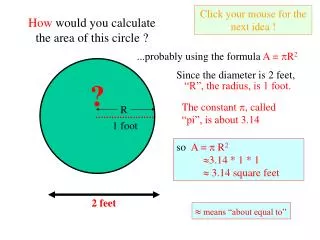
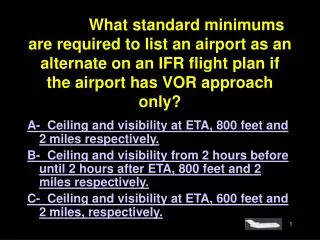
#4085. What standard minimums are required to list an airport as an alternate on an IFR flight plan if the airport has VOR approach only?. A- Ceiling and visibility at ETA, 800 feet and 2 miles respectively.

E N D
#4085. What standard minimums are required to list an airport as an alternate on an IFR flight plan if the airport has VOR approach only? A- Ceiling and visibility at ETA, 800 feet and 2 miles respectively. B- Ceiling and visibility from 2 hours before until 2 hours after ETA, 800 feet and 2 miles respectively. C- Ceiling and visibility at ETA, 600 feet and 2 miles, respectively.
Sorry that is Incorrect. Go Back and Try Again.
That’s Right!!! Next Question
#4475. Uncontrolled airspace is that airspace where A- ATC does not control air traffic. B- ATC controls only IFR flights which originate in controlled airspace and terminate in controlled airspace. C- the minimum visibility for flight is 1 mile.
Sorry that is Incorrect. Go Back and Try Again.
That’s Right!!! Next Question
#4060. When filing a composite flight plan where the first portion of the flight is IFR, which fix(es) should be indicated on the flight plan form? A- All points of transition from one airway to another, fixes defining direct route segments, and the clearance limit fix. B- Only the fix where you plan to terminate the IFR portion of the flight. C- Only those compulsory reporting points on the IFR route segment.
Sorry that is Incorrect. Go Back and Try Again.
That’s Right!!! Next Question
#4280. At which altitude and location on V573 would you expect the navigational signal of the HOT VOR/DME to be unreliable? See fig.34. A- 2,600 feet at MARKI intersection. B- 4,000 feet at ELMMO intersection. C- 3,000 feet at APINE intersection.
Sorry that is Incorrect. Go Back and Try Again.
That’s Right!!! Next Question
#4080. What is the purpose of FDC NOTAMS? A- To provide the latest information on the status of navigation facilities to all FSS facilities for scheduled broadcasts. B- To issue notices for all airports and navigation facilities in the shortest possible time. C- To advise of changes in flight data which affect instrument approach procedures, aeronautical charts, and flight restrictions prior to normal publication.
Sorry that is Incorrect. Go Back and Try Again.
That’s Right!!! Next Question
#4460. What action should you take if your No. 1 VOR receiver malfunctions while operating in controlled airspace under IFR? Your aircraft is equipped with two VOR receivers: the No. 1 receiver has Omni/Localizer/Glide Slope capability, and the No. 2 has only Omni. A- Report the malfunction immediately to ATC. B- Continue the flight as cleared; no report required. C- Continue the approach and request a VOR or NDB approach.
Sorry that is Incorrect. Go Back and Try Again.
That’s Right!!! Next Question
#4515. What is the function of the Great Falls RCO? Yellow Stone vicinity, see fig 91. A- Long range communications outlet for Great Falls Center. B- Remote communications outlet for Great Falls FSS. C- Satellite FSS controlled by Great Falls FSS with limited service.
Sorry that is Incorrect. Go Back and Try Again.
That’s Right!!! Next Question
#4392. What is the significance of an ATC clearance which reads “…CRUISE SIX THOUSAND…”? A- The pilot must maintain 6,000 feet until reaching the IAF serving the destination airport, then execute the published approach procedure. B- Climbs may be made to, or descents made from, 6,000 feet at the pilot’s discretion. C- The pilot may utilize any altitude from the MEA/MOCA to 6,000 feet, but each change in altitude must be reported to ATC.
Sorry that is Incorrect. Go Back and Try Again.
That’s Right!!! Next Question
#4605. During the en route phase of an IFR flight, the pilot is advised “Radar service terminated.” What action is appropriate? A- Set transponder to code 1200. B- Resume normal position reporting. C- Activate the IDENT feature of the transponder to re-establish radar contact.
Sorry that is Incorrect. Go Back and Try Again.
That’s Right!!! Next Question
#4456. Which report should be made to ATC without a specific request when not in radar contact? A- Entering instrument meteorological conditions. B- When leaving final approach fix inbound on final approach. C- Correcting an E.T.A. any time a previous E.T.A. is in error in excess of 2 minutes.
Sorry that is Incorrect. Go Back and Try Again.
That’s Right!!! Next Question
#4071. For which speed variation should you notify ATC? A- When the groundspeed changes more than 5 knots. B- When the average true airspeed changes 5 percent or 10 knots, whichever is greater. C- Any time the groundspeed changes 10 MPH.
Sorry that is Incorrect. Go Back and Try Again.
That’s Right!!! Next Question
#4711. Where may you use a surveillance approach? A- At any airport that has an approach control. B- At any airport which has radar service. C- At airports for which civil radar instrument approach minimums have been published.
Sorry that is Incorrect. Go Back and Try Again.
That’s Right!!! Next Question
#4758. If during a VFR practice instrument approach, Radar Approach Control assigns an altitude or heading that will cause you to enter the clouds, what action should be taken? A- Enter the clouds, since ATC authorization for practice approaches is considered an IFR clearance. B- Avoid the clouds and inform ATC that altitude/heading will not permit VFR. C- Abandon the approach.
Sorry that is Incorrect. Go Back and Try Again.
That’s Right!!! Next Question
#4297. What is the difference in elevation (in feet MSL) between the airport elevation and the TDZE for RWY 36L?See fig 42a A- 15 feet. B- 18 feet. C- 22 feet.
Sorry that is Incorrect. Go Back and Try Again.
That’s Right!!! Next Question
#4357. Which runway and landing environment lighting is available for approach and landing on RWY 6 at Bradley International? See fig 73, Legend 19. A- HIRL, REIL, and VASI. B- HIRL and VASI. C- ALSF2 and HIRL.
Sorry that is Incorrect. Go Back and Try Again.
That’s Right!!! Next Question
#4796. The primary purpose of runway end identifier lights, installed at many airfields, is to provide A- rapid identification of the approach end of the runway during reduced visibility. B- a warning of the final 3,000 feet of runway remaining as viewed from the takeoff or approach position. C- rapid identification of the primary runway during reduced visibility.
Sorry that is Incorrect. Go Back and Try Again.
That’s Right!!! Next Question
#4792. What is the distance (B) from the beginning of the runway to the touchdown zone marker? See fig 137. A- 250 feet.B- 500 feet. C- 750 feet.
Sorry that is Incorrect. Go Back and Try Again.