Download
1 / 67
690 likes | 881 Vues
The Hydrology and Fluvial Geomorpholy. Water has changed little over the past hundred million years. Water moves around the world, changes forms, is taken in by plants and animals, but never really disappears. It travels in a large, continuous loop.

E N D
Water has changed little over the past hundred million years. • Water moves around the world, changes forms, is taken in by plants and animals, but never really disappears. It travels in a large, continuous loop. • It is a closed system, meaning it has no other interferences; what goes in stays in. It does not change as it evolves. No gains or losses from outside are added to the system
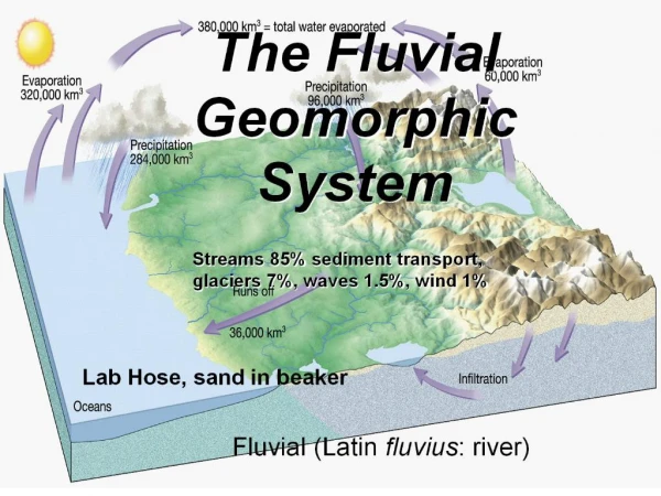
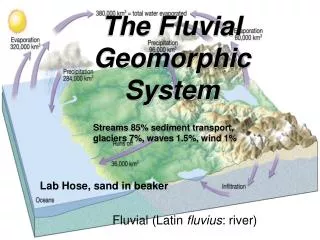
The movement of water from the sea through the air to the land and back to the sea.
How does it work? • It is a system of inputs, stores and flows. • Water covers 70% of the earth’s surface • Water exists in three states: liquid, solid and invisible vapour (gas). • It forms the oceans, seas, lakes, rivers and the underground waters found in the top layers of the earth’s crust and soil cover. • In a solid state, it exists as ice and snow cover in polar and alpine regions. • A certain amount of water is contained in the air as water vapour, water droplets and ice crystals, as well as in the biosphere. Huge amounts of water are bound up in the composition of the different minerals of the earth’s crust and core.
How does the Hydrological Cycle work? The stages of the cycle are: • Evaporation • Transport • Condensation • Precipitation • Groundwater • Run-off
Evaporation • Water is transferred from the surface to the atmosphere through evaporation, the process by which water changes from a liquid to a gas. The sun’s heat provides energy to evaporate water from the earth’s surface. Land, lakes, rivers and oceans send up a steady stream of water vapour and plants also lose water to the air (transpiration). • Approximately 80% of all evaporation is from the oceans, with the remaining 20% coming from inland water and vegetation.
Transport • The movement of water through the atmosphere, specifically from over the oceans to over land, is called transport. Some of the earth’s moisture transport is visible as clouds, which themselves consist of ice crystals and/or tiny water droplets. • Clouds are propelled from one place to another by either the jet stream, surface-based circulations like land and sea breezes or other mechanisms. However, a typical cloud 1 km thick contains only enough water for a millimeter of rainfall, whereas the amount of moisture in the atmosphere is usually 10-50 times greater than this. • Most water is transported in the form of water vapour, which is actually the third most abundant gas in the atmosphere. Water vapour may be invisible to us, but not to satellites which are capable of collecting data about it.
Condensation • The transported water vapour eventually condenses, forming tiny droplets in clouds.
Precipitation • The primary mechanism for transporting water from the atmosphere to the surface of the earth is precipitation. • When the clouds meet cool air over land, precipitation, in the form of rain, sleet or snow, is triggered and water returns to the land (or sea). A proportion of atmospheric precipitation evaporates.
Groundwater • Some of the precipitation soaks into the ground and this is the main source of the formation of the waters found on land - rivers, lakes, groundwater and glaciers. • Some of the underground water is trapped between rock or clay layers - this is called groundwater. Water that infiltrates the soil flows downward until it encounters impermeable rock and then travels laterally. The locations where water moves laterally are called ‘aquifers’. Groundwater returns to the surface through these aquifers, which empty into lakes, rivers and the oceans. • Under special circumstances, groundwater can even flow upward in artesian wells. The flow of groundwater is much slower than run-off with speeds usually measured in centimetres per day, metres per year or even centimetres per year.
Run-off • Most of the water which returns to land flows downhill as run-off. Some of it penetrates and charges groundwater while the rest becomes river flow. As the amount of groundwater increases or decreases, the water table rises or falls accordingly. When the entire area below the ground is saturated, flooding occurs because all subsequent precipitation is forced to remain on the surface. • Different surfaces hold different amounts of water and absorb water at different rates. As a surface becomes less permeable, an increasing amount of water remains on the surface, creating a greater potential for flooding. Flooding is very common during winter and early spring because frozen ground has no permeability, causing most rainwater and meltwater to become run-off.
Drainage Basins • Geomorphologist and hydrologists often view streams as being part of drainage basins. A drainage basin is the topographic region from which a stream receives runoff, throughflow, and groundwater flow. Drainage basins are divided from each other by topographic barriers called a watershed .A watershed represents all of the stream tributaries that flow to some location along the stream channel.
The following image shows the nested nature of drainage basins as determined from a topographic map sheet. The red lines describe the watersheds for the drainage basins of first order streams. The yellow lines define the watersheds for two drainage basins from locations further upstream.
Drainage basins are commonly viewed by scientists as being open systems. • Inputs to these systems include precipitation, snow melt, and sediment. Drainage basins lose water and sediment through evaporation, deposition, and streamflow. • A number of factors influence input, output, and transport of sediment and water in a drainage basin. Such factors include topography, soil type, bedrock type, climate, and vegetation cover. These factors also influence the nature of the pattern of stream channels
Hydrographs:A hydrograph may be used to show how the water flow in a drainage basin (particularly river runoff) responds to a period of rain. • This type of hydrograph is known as a storm or flood hydrograph and it is generally drawn with two vertical axes. One is used to plot a line graph showing the discharge of a river in cumecs (cubic metres per second) at a given point over a period of time. The second is used to plot a bar graph of the rainfall event which precedes the changes in discharge. • The scale on the horizontal axis is usually in hours/days and this allows both the rain event to be recorded and the subsequent changes in river discharge to be plotted
Shape • The shape of the hydrograph varies according to a number of controlling factors in the drainage basin but it will generally include the following features. • The baseflow of the river represents the normal day to day discharge of the river and is the consequence of groundwater seeping into the river channel. The rising limb of the hydrograph represents the rapid increase in resulting from rainfall causing surface runoff and then later throughflow. Peak discharge occurs when the river reaches its highest level. The time difference between the peak of the rain event and the peak discharge is known as the lag time or basin lag. The falling limb (or recession limb as it is sometimes known) is when discharge decreases and the river’s level falls. It has a gentler gradient than the rising limb as most overland flow has now been discharged and it is mainly throughflow which is making up the river water.
Influence of basin shape • A number of factors (known as drainage basin controls) influence the way in which a river responds to precipitation and have an effect on the shape of the hydrograph. • The size, shape and relief of the basin are important controls. Water takes longer to reach the trunk stream in a large, round basin than in does in a small, narrow one
Influence of steepness • Where gradients are steep, water runs off faster, reaches the river more quickly and causes a steep rising limb. Prolonged heavy rain causes more overland flow than light drizzly rain
Differences • Areas of permeable rocks and soil allow more infiltration and so less surface run off.
Water balance • A general water balance equation is: P = Q + E + ΔS • Where : P is precipitation • Q is runoff • E is evapotranspiration, • ΔS is the change in storage (in soil or the bedrock) • A water balance can be used to help manage water supply and predict where there may be water shortages. It is also used in irrigation, flood control and pollution control. • The water balance can be illustrated using a water balance graph which plots levels of precipitation and evapotranspiration often on a monthly scale. • Several monthly water balance models had been developed for several conditions and purposes. Monthly water balance models had been studied since the 1940s.
(1) RIVER PROCESSES. (2) DEPOSITION & SEDIMENTATION (HJULSTROM CURVE) (3) VELOCITY & DISCHARGE (4) PATTERNS OF FLOW (5) CHANNEL TYPES (6) CHANNEL LANDFORMS (7) FLOOD (CAUSES, IMPACT AND MANAGEMENT) RIVER CHANNEL PROCESSES & LANDFORMS, FLOOD & MANAGEMENT
RIVER PROCESSES: Three river processes: • Transportation • Deposition • Erosion
RIVER TRANSPORTATION The load is transported by 4 ways: • Saltation: when pebbles, sand and gravel (bedload) are lifted up by current and bounced along the bed in a hopping motion. (ii) Traction: when largest boulders and cobbles (bedload) roll or slide along the bed. traction saltation
(iii) Suspension: very fine particle such as clay and silt (suspended load) are dislodged and carried by turbulence in a fast flowing river. • Solution: water flowing within a river channel contains acids (e.g. carbonic acid from precipitation) dissolve the load such as limestone in running water and removed in solution. suspension solution
River deposition Deposition: When velocity begins to fall, it has less energy and no longer had competence and capacity to carry all its load so largest particles, materials begins to be deposited. When occur? • Low discharge during period of low precipitation • Less velocity when river enter sea or lake. • Shallow water occurs on inside of a meander. • The load suddenly increase (debris from landslide) • River overflow its bank so velocity outside channel is reduced. (resulting in floodplain)
River erosion. Erosion: wearing away of river bed and bank. There are four main process of erosion: • Corrasion: occurs when the river picks up materials and rubs it along its bed and banks, wearing them away by abrasion, effective during flood. Major method by which river erodes both vertically and horizontally. Landforms: potholes. (turbulent eddies in the current can swirl pebbles around to form potholes that are hollows in river bed and pebbles are likely to become trapped) potholes
Attrition: As bedload moved downstream, boulders collide with other material and the impact may break the rock into smaller pieces. In time angular rocks become increasingly rounded. • Solution/corrosion: This process in independent of river discharge and velocity. It is related to chemical composition of water e.g. concentration of carbonic acid and humid acid. • Hydraulic action: The sheer force of the water as the turbulent current hits banks (outside of meander) pushes water into cracks. The air in cracks compressed, pressure increased and in time bank will collapse. Cavitation: is a form of hydraulic action caused by bubbles of air collapsing.
Hjulstromcurve • The Hjulstrøm curve is a graph used by hydrologists to determine whether a river will erode, transport or deposit sediment. The graph takes sediment size and channel velocity into account. • The curve shows several key ideas about the relationships between erosion, transportation and deposition. The Hjulstrøm Curve shows that particles of a size around 1mm require the least energy to erode, as they are sands that do not coagulate. Particles smaller than these fine sands are often clays which require a higher velocity to produce the energy required to split the small clay particles which have coagulated. Larger particles such as pebbles are eroded at higher velocities and very large objects such as boulders require the highest velocities to erode. When the velocity drops below this velocity called the line of critical velocity, particles will be deposited or transported, instead of being eroded, depending on the river's energy.
Velocity and Discharge: Discharge: is the amount of water originating as precipitation which reaches the channel by surface runoff, throughflow and baseflow. Q = A X V (Q: discharge, A: cross-sectional area and V: velocity)
Velocity: 1. Velocity: speed of a river (m/s) 2. Velocity of a river is influence by 3 factors: • Channel shape in cross-section. • Roughness of the channel’s bed and banks. • Channel slope.
Patterns of flow As water flows downhills under gravity, velocity decreases. This is not only due to friction found along river bed and banks, but also internal friction of water and air resistance on the surface. There are two patterns of flow: 1.Laminar flow : horizontal movement of water (rarely found), common in lava flow. 2. Turbulent: a series of erratic eddies, both vertical and horizontal, in a downstream direction.
3. Helicoidal flow: a corkscrew movement, in a meander. It is responsible for moving material from the outside of one meander bend and depositing on the inside of the next bend.
Channel types (a) Straight channel (b) Braided channel (c) Meander channel
Braided channel What? A braided stream has islands/ eyots of deposited material within the channel. Description: Overall channel is straight with eyots and smaller channels. It rapidly and frequently change position. When? It occurs when the load contain high proportion of coarser sands and gravel. Area: Semi-arid environment. Braided reach of Lillooet River, southwestern British Columbia.
Meander • WHAT? Bends in course of a river channel. • HOW OCCUR? • Begin when a river approaches its middle course & gradient channel • is less steep. • 2. It results from helicoidal flow with faster current spirals downstream in • corkscrew fashion. Movement result in erosion on outside bend of meander to • form river cliff and deposit on inside bend called slip off slope. • CHARACTERISTICS: • River cliff on outside of bend and gentle • sloping slip- off slope called point bar on • inside of bend of meander.
Riffle and pools Riffles: deposition of a coarse material that create areas of shallow water. Pools: areas of deeper water between riffles. Pools and riffles developed in section along river channel which create different gradient of channel. Coarse pebbles create steeper gradient than eroded pools.
River Profile This is a Profile of a River-Middle, Upper and Lower Stages:
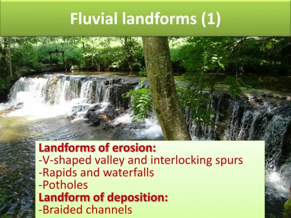
Upper Course • In the upper course of the river, there are many features. • The river channel is narrow and fast, with interlocking spurs and v-shaped valleys • Steep drops in the river with extremely fast flows are waterfalls, with retreating gorges of recession, ending with a plunge pool.
Fluvial landforms Effects of fluvial erosion: • (a) V-shaped valleys A river erode vertically by traction or saltation which resulted in a steep- sided valley called a V-shaped valley. Steepness of valley sides depend of factors such as: • Climate: valley are steeper where there is sufficient rainfall. (for mass movement and allow river to transport bedload and erode vertically) • Rock structure: resistant, permeable rocks such as limestone produce vertical sides. • Vegetation: it helps to bind soil together and keep the hillslope more stable.
Forming a V shaped Valley Vertical erosion is dominant The river cuts downwards like a saw. This happens in the upper part of the river and makes the valley go deep. Rain erodes the edges to make it wider at the top.
Interlocking spurs It forms because the river is forced to follow a winding course around the protrusions of the surrounding highland, resulting in spurs interlock. Interlocking spur.
2. Water fall: A waterfall form when a river, after flowing over relatively hard rock meets a band of less resistant rock flow over the edge of a plateau. Over a period of years, the edges of this shelf will gradually break away and the waterfall will steadily retreat upstream, creating a gorge of recession. Havasu fall, Arizona.