
Transform Your Projects with Accurate Laser Mapping and 3D Modeling Solutions
E N D
Presentation Transcript
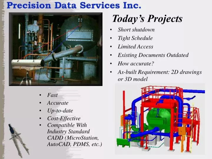
Today’s Projects • Short shutdown • Tight Schedule • Limited Access • Existing Documents Outdated • How accurate? • As-built Requirement: 2D drawings or 3D model • Fast • Accurate • Up-to-date • Cost-Effective • Compatible With Industry Standard CADD (MicroStation, AutoCAD, PDMS, etc.)
Laser Mapping Consolidate Scans Create Surface Model from Scans Single Scan Existing Facility Export Model to CADD
For more information contact: Harvey A. Maier Spatial Data Specialist Phone: (905)304-8064 Fax: (561)594-3744 e-mail: maier@pdsiweb.com www.PDSIweb.com Benefits of our Service • Value-added Service • Direct Cost Savings • Reduce Time/Labor Onsite • Faster Field to Design time • Reduce Time in design phase • Better quality data up front will result in better design and reduce the cost of construction rework • Resource Multiplier • Quality - Meets or Exceeds Customer Requirements (up to 0.3mm accuracy) Collects More Data Than Any Other System or Method With a Degree of Accuracy Not Matched • Safety – Reduce risk of injury in areas difficult to access & reduce exposure to hostile environments "With regard to cost, cost control, convenience, speed, and the specific application to "Laser Scanning", your process comes out way ahead of Digital Photogrammetry. Laser Mapping was much less disruptive to the area being scanned and resulted in reduced downtime and waste product.” - Manufacturing Engineer -