Download
1 / 13
130 likes | 340 Vues
Michael Ek and the EMC Land-Hydrology Team Environmental Modeling Center (EMC) National Centers for Environmental Prediction (NCEP) NOAA/NWS. NCEP Production Suite Review: Land-Hydrology at NCEP. NCEP Production Suite Review, 6-8 December 2011 NOAA Science Center, Camp Springs, Maryland.

E N D
Michael Ek and the EMC Land-Hydrology Team Environmental Modeling Center (EMC) National Centers for Environmental Prediction (NCEP) NOAA/NWS NCEP Production Suite Review:Land-Hydrology at NCEP NCEP Production Suite Review, 6-8 December 2011 NOAA Science Center, Camp Springs, Maryland
seasonal storage Land model role: Energy Budget • Noah land model closes the surface energy budget, & provides surface boundary conditions to NCEP models.
Land model role: Hydrological Cycle • Noah land model closes the surface water budget, & provides surface boundary conditions to NCEP models.
NCEP-NCAR unified Noah land-surface model • Noah model has realistic land physics & is coupled with NCEP short-range NAM, medium-range GFS, and seasonal CFS, and run “uncoupled”, i.e. NLDAS, and GLDAS (in Climate Forecast System).
NCEP-NCAR unified Uncoupled “NLDAS” (drought) Forecast NOAH Land Surface Model Noah Land Model Connections in NOAA’s NWS Model Production Suite Oceans HYCOM WaveWatch III Climate CFS 2-Way Coupled Hurricane GFDL HWRF MOM3 1.7B Obs/Day Satellites 99.9% Dispersion ARL/HYSPLIT Regional NAM WRF NMM (including NARR) Global Forecast System Global Data Assimilation Severe Weather Regional Data Assimilation WRF NMM/ARW Workstation WRF Short-Range Ensemble Forecast North American Ensemble Forecast System WRF: ARW, NMM ETA, RSM Air Quality GFS, Canadian Global Model NAM/CMAQ Rapid Update for Aviation (ARW-based)
Land model validation • Low-level observations (e.g. 2-m temperature & humidity, 10-m winds); 10+ year data set. • Additionally: upper air scores, precipitation threat & bias scores, specific flux site validation. www.emc.ncep.noaa.gov/mmb/research/nearsfc/nearsfc.verf.html west 2010 east 5 4 July monthly diurnal 10-m wind (m/s) 3 3 2011 5 4 obs: solid, NAM: short-dash, GFS: long-dash 3 3 0 0 24 24 48 48 72hr 72hr 00Z Forecast Cycle
2011: NMMB & New Land Data Set • New land-use (vegetation type) data set based on MODIS used by Noah land model in NAM. Land-use type (1-km, MODIS) • Better surface representation yields better surface fluxes and temperature forecasts in NAM.
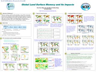
2011: CFSv2 and Land • Noah replaced OSU land model in CFS (from GFS). • Global Land Data Assimilation System (GLDAS): Daily update of land states via uncoupled Noah driven by CFS assimilation cycle atmospheric forcing and blended observations+model precipitation. • Reasonable soil moisture climatology, and energy & water budgets closure. • Reanalysis as initial conditions for reforecasts. May Soil Moisture Climatology from 30-year NCEP Climate Forecast System Reanalysis (CFSR), spun up from Noah land model coupled with CFS. 8
2012: Extend GFS upgrade to NAM • Surface layer (surfaceroughness) modifications in GFS (Xubin Zeng et al, Univ. Arizona) in 2010. Operational: Cold bias in skin temperature (left), warm bias in air temperature (e.g. 48-hr 850mb fcst, right). GFS-GOES, 3-day mean: 1-3July2007 00z08Jul2008-00z10Nov2008 New roughness: Improved skin temperature (left), air temperature (right).
2012: North American Land Data Assimilation System (NLDAS) • Noah, SAC, VIC, Mosaic land models run uncoupled, driven by CPC observed precipitation and atmos. forcing from NCEP North American Regional Climate Data Assimilation System; output: 1/8-deg. land & soil states, surface fluxes, runoff & streamflow. • Land model runs provide a 30-year climatology. • Anomalies used for drought monitoring; supports National Integrated Drought Information System. www.emc.ncep.noaa.gov/mmb/nldas July 30-year climo. July 1988 (drought) July 1993 (flood) July 2011 NLDAS four-model ensemble monthly soil moisture anomaly
Green Vegetation Frac. (AVHRR) Leaf Area Index (MODIS) 2012: New land data sets • Near realtime greenness frac. • LAI (Leaf Area Index) = veg. density GVF June 2007 LAI • MODIS snow-free albedo • MODIS max snow albedo • Better surface representation should yield better surface fluxes and T, RH, wind forecasts. • Update NAM, GFS, and other NCEP systems.
Future Land Model/Related Upgrades • Important for high-res (~downscaling): Lake model & climatologies in NAM then GFS; Fire/burned area (account for surface changes); cycle land in future. • Assimilation of surface quantities, e.g. soil moisture, surface temperature, snowpack, vegetation fraction. • Surface layer turbulent mixing in stable conditions: affects surface fluxes and night-time temperatures. • Under NEMS, unify Noah model in NCEP systems. • River routing/streamflow (discharge to oceans). • New Noah land model (coop. with NCAR/others): 3-layer snowpack, explicit canopy, dynamic vegetation, CO2-based transpiration, ground-water, air quality, ecosystems & biogeochemical cycles.
Physics “Wheel of Pain” Questions?