Download
1 / 1
10 likes | 149 Vues
Impact of a Last Glacial Maximum sea-level drop on the circulation of the Mediterranean Sea. Alexandra Bozec 1 , Masa Kageyama 2 , Gilles Ramstein 2 and Michel Crépon 3 (abozec@coaps.fsu.edu) 1 Center for Ocean-Atmospheric Predictions Studies, Florida State University, Tallahassee, FL, USA

E N D
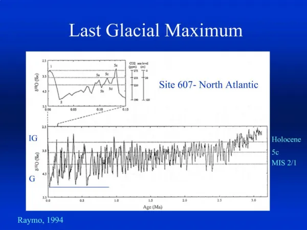
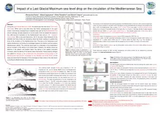
Impact of a Last Glacial Maximum sea-level drop on the circulation of the Mediterranean Sea Alexandra Bozec1, Masa Kageyama2, Gilles Ramstein2 and Michel Crépon3(abozec@coaps.fsu.edu) 1Center for Ocean-Atmospheric Predictions Studies, Florida State University, Tallahassee, FL, USA 2Laboratoire des Sciences du Climat et de l’Environnement, Gif-sur-Yvette, France 3Laboratoire d’Océanographie et de Climatologie -Expérimentations et Approches numériques-, Paris, France • The evolution of the temperature and salinity properties of the Mediterranean at the end of the numerical experiment is then only due to changes in circulation and/or atmospheric forcing associated with the change in the surface of the Sea. In BAT, the Mediterranean Sea is colder (-0.45°C above 1400m) and saltier (+0.06 psu beneath 1200m) leading to an increase of the global density of the basin (Fig. 2 a, b and c). The larger density increase appears between 200 and 1500m (+0.1 kg/m3 above 1700m; Fig 2, c). This changes appear also in the surface with a decrease of the temperature of 0.5°C and a slight increase of the salinity of +0.03 psu. • Temperature: • In the western basin, the temperature decreases above 2000m compared to REF (Fig. 2 d). • In the eastern basin, the BAT experiment temperature profile is more homogeneous beneath 500m leading to a temperature 0.5°C colder above 1200m and 0.4°C warmer below this depth (Fig. 2 g). This decrease of temperature above 1000m is fully consistent with the weakening of the circulation, as shown in the next section. • Salinity: • In the eastern basin, salinity increases over the whole water column while in the western basin salinity decreases beneath 600m (Fig 2. b, e and h). • These differences between the REF and BAT temperature and salinity profiles can be explained by analyzing changes in the heat and freshwater budgets (Figure 3). Abstract: During the Last Glacial Maximum (LGM), the global sea level was about 120m lower than today. While such a sea level drop has limited consequences in the open ocean, it has strong consequences in marginal seas such as the Mediterranean Sea whose hydrology strongly depends on narrow straits. Here we analyse the impact of the LGM sea-level decrease on the Mediterranean Sea using a 1/8° resolution ocean model. With a sea-level lowered by 120 m, the water mass transports at the Gibraltar and Sicily straits are reduced by about two thirds, leading to a global slow down of the circulation of the Mediterranean Sea. This acts on the temperature and salinity distributions, by limiting the exchanges between the western and the eastern Mediterranean basins. The sea-level drop leads to a decrease of the temperature and an increase of the salinity of the whole basin. However, the salinity trends are different in the eastern and western basin: the salinity of the eastern sub-basin increases, while the salinity of the western basin decreases.These property changes are related to changes in two components: the atmospheric forcing acting on the Mediterranean Sea and the exchanges at the Gibraltar and Sicily Straits. In this study, we show that the decrease of the exchanges at these straits is the main factor controlling the Mediterranean Sea properties. • Figure 2: Vertical profiles of temperature (°C), salinity (psu) and density (kg/m3)for a,b and c the Mediterranean basin, d, e and f for the western sub-basin and g, h and i for the eastern sub-basin. Black line corresponds to BAT and grey line to REF. • Figure 3. Scheme of the straits circulation of the Mediterranean Sea for a) REF and b) BAT. In red is the contribution of the heat transport in 1012 W and in blue the contribution of the freshwater transport in mSv (103 m3/s). HEAT BUDGET: The heat transport entering the Mediterranean Sea and reaching the eastern basin is twice as low as in REF (Fig. 3 b). In the western basin, the atmospheric heat loss is more important leading to a larger deficit (-1.43 1012 W or -1.72 W/m2) and consequently to a colder temperature of the water column (Fig 2. d). In the eastern basin, despite a decrease of the averaged heat flux lost to the atmosphere, the quantity of heat brought through the Sicily strait is insufficient to keep the same temperature as in REF. Combined with deep convection occurring in the basin that homogenizes the temperature of the water column, the temperature profile of the eastern basin can be easily understood (Fig 2. g). FESHWATER BUDGET : In BAT, the exchanges between the eastern and the western basins also decrease, restricting the amount of fresher surface water entering the eastern basin and the amount of salty deep water entering the western basin. In the eastern basin, the freshwater balance is smaller than the REF experiment budget (+0.21 mSv) explaining the increase of salinity. In the western basin, the combined effect of the decreased import of salty water from the eastern basin and the reverse sign of the E-P-R flux makes the freshwater balance of the western basin more important than in REF (+2.15 mSv) explaining the decrease of salinity of this basin. The numerical model, hereafter MED8, has a resolution of 1/8° for longitude and 1/8°cos for latitude. MED8 is one of the Mediterranean configurations of the ocean model OPA (Madec et al., 1998). The model characteristics are described in Bozec et al. (2006). Two simulations of 50 years forced by the ECMWF climatology were realized. REF is the control simulation with the present sea level. BAT was realized with a 120m sea level decrease. The mask and bathymetry of the two configurations are presented in Figure 1. The BAT configuration presents a less important volume basin than the REF configuration (-7.5%) and a less important area at the surface (-13%). Most changes appear in the Adriatic Sea and along the Tunisian coasts where the shelf is shallow. The Gibraltar strait is now 170 mdeep and the Sicily strait is reduced to a thin channel with a sill at 275m depth and a width of 45 km instead of 125 km. Figure 1: a) Bathymetry and mask of the present simulation (REF) and b) bathymetry and mask for a 120m sea-level decrease (BAT). The water mass transports at the different straits decrease significantly (2/3 less). Despite an increase of the average salinity of the Mediterranean Sea, the Mediterranean outflow waters are fresher. The circulation at the different straits then mainly control the distribution of heat and freshwater in the Mediterranean Sea as discussed in Astraldi et al. (1999) for the present situation. Reference: Astraldi, M.,Balopoulos, S.,Candela,J., Font, J.,Gacic, M.,Gasparini, G.P., Manca, B., Theocharis, A.,Tintore H, J.,1999. The role of straits and channels in understanding the characteristics of Mediterranean circulation. Progress in Oceanography 44 (1-3), 65-108. Bozec, A., Bouruet-Aubertot, P., Béranger, K., Crépon, M., 2006: Mediterranean oceanic response to the interannual variability of a high resolution atmospheric forcing: a focus on the Aegean sea. Journal of Geophysical Research, 111, C11013, doi:10.1029/2005JC003427. Madec, G. ., Delecluse, P., Imbard, M., Lévy, C., 1999: OPA8.1, Ocean General Circulation Model, Reference manual. 97pp