Download
1 / 36
360 likes | 487 Vues
This guide explores the levels of exposure to emissions from various sources, addressing concerns about family safety and environmental impact on plants, animals, and infrastructure. It details factors influencing exposure including emission rates, terrain, and pollutant transport. The lab provides insights on model applications for regulatory purposes, highlighting methodologies like dispersion and receptor models. Furthermore, it discusses the suitability of models for different terrains and the level of detail needed for accurate analysis, along with real-world examples such as chemical spills and military operations.

E N D
ENV 6146/6932/4932 Atmospheric Modeling Aerosol & Particulate Research Lab
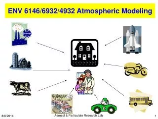
Q: What is the level of my exposure to these emissions? Is my family safe? Where is safe? How about the adverse impact on the environment (plants, animals, buildings)? Q: Any other real examples? Aerosol & Particulate Research Lab
Newberry/Suwannee Cement Plant Chemical Spill Landfill gas Military Operation Pb concentration along highway Visibility BP Oil Rig Explosion Aerosol & Particulate Research Lab
Q: What are the factors that affect the exposure to the emissions? • Temporal and spatial emission rates • Terrain • Chemical transformation • Equilibrium between particles and gases • Pollutant transport • Vertical Mixing Aerosol & Particulate Research Lab
Meteorological Model Emission Model Chemical Model Temporal and spatial emission rates Topography Chemical Transformation Pollutant Transport Equilibrium between Particles and gases Vertical Mixing Source Dispersion Model Receptor Model Air Quality Models Aerosol & Particulate Research Lab
Emission Model • Estimates temporal and spatial emission rates based on activity level, emission rate per unit of activity and meteorology • Meteorological Model • Describes transport, dispersion, vertical mixing and moisture in time and space • Chemical Model • Describes transformation of directly emitted particles and gases to secondary particles and gases; also estimates the equilibrium between gas and particles for volatile species Aerosol & Particulate Research Lab
Source Dispersion Model • Uses the outputs from the previous models to estimate concentrations measured at receptors; includes mathematical simulations of transport, dispersion, vertical mixing, deposition and chemical models to represent transformation. Gaussian Plume, Puff and Grid Models. • Receptor Model • Infers contributions from different primary source emissions or precursors from multivariate measurements taken at one ore more receptor sites. Chemical Mass Balance (CMB), Time Series, Neural Networks Q: When are model applications required for regulatory purposes? Aerosol & Particulate Research Lab
Regulatory Application of Models • PSD: Prevention of Significant Deterioration of Air Quality in relatively clean areas (e.g. National parks) • SIP: State Implementation Plan revisions for existing sources and for New Source Reviews (NSR) Q: Which type of model is better? Which one should I use? Aerosol & Particulate Research Lab
Guideline on Air Quality Models • Revised 40 CFR Pt 51, App. W. – effective 11/9/2005 (http://www.epa.gov/scram001/guidance/guide/appw_05.pdf) • Overview of Model Use • Recommended Air Quality Models – Preferred and Alternative • Traditional Stationary Source Models • Model use in Complex Terrain • Models for O3, PM, CO and NO2 • Other Model Requirements • General Modeling Considerations • Model Input Data • Accuracy and Uncertainty of Models • Regulatory Application of Models Aerosol & Particulate Research Lab
Suitability of Models • The meteorological and topographical complexities of the area • The level of detail and accuracy need for the analysis • The technical competence of those undertaking such simulation modeling • The resources available • The detail and accuracy of the data base; i.e. emission inventory, meteorological data and air quality data Aerosol & Particulate Research Lab
Topography Simple Terrain • Terrain features are all lower in elevation than the top of the stack of the source • Criteria pollutants • Average time of concentration estimates ranges from 1 hour to annual average Complex Terrain • Terrain exceeding the height of the stack • SO2 and PM from stationary source http://www.fire.nist.gov/fire/aloft/ Aerosol & Particulate Research Lab
Levels of Sophistication of Models • Screening: simple estimation techniques use preset, worst-case meteorological conditions to provide conservative estimates. Purpose? • Refined: Analytical techniques that provide more detailed treatment of physical and chemical atmospheric processes, require more detailed and precise input data and provide more specialized concentration estimates. So what? Aerosol & Particulate Research Lab
Screening Models • Available at http://www.epa.gov/ttn/scram/dispersion_screening.htm • AERSCREEN: a screening model based on AERMOD. The model will produce estimates of "worst-case" 1-hour concentrations for a single source, without the need for hourly meteorological data, and also includes conversion factors to estimate "worst-case" 3-hour, 8-hour, 24-hour, and annual concentrations. • RTDM3.2 (Rough Terrain Diffusion Model): a sequential Gaussian plume model designed to estimate ground-level concentrations in rough (or flat) terrain in the vicinity of one or more co-located point sources. Aerosol & Particulate Research Lab
CTSCREEN (Complex Terrain Screening model):a Gaussian plume dispersion model designed as a screening technique for regulatory application to plume impaction assessments in complex terrain. • SCREEN3: a single source Gaussian plume model which provides maximum ground-level concentrations for point, area, flare, and volume sources, as well as concentrations in the cavity zone, and concentrations due to inversion break-up and shoreline fumigation. • TSCREEN: (Toxics Screening) a Gaussian model that implements the procedures to correctly analyze toxic emissions and their subsequent dispersion from one of many different types of possible releases for superfund sites. It contains 3 models within it, SCREEN3, PUFF, and RVD (Relief Valve Discharge). Aerosol & Particulate Research Lab
VISCREEN: calculates the potential impact of a plume of specified emissions for specific transport and dispersion conditions. • VALLEY: a steady-state, complex terrain, univariate Gaussian plume dispersion algorithm designed for estimating either 24-hour or annual concentrations resulting from emissions from up to 50 (total) point and area sources. • COMPLEX1: a multiple point source screening technique with terrain adjustment that incorporates the plume impaction algorithm of the VALLEY model • CAL3QHC/CAL3QHCR: a CALINE3 based CO model with a traffic model to calculate delays and queues that occur at signalized intersections • Pick one Screening Model for your Project 1. Aerosol & Particulate Research Lab
Preferred/Recommended Models • Preferred Modeling Techniques • A single model found to outperform others • Selected on the basis of other factors such as past use, public familiarity, cost or resource requirements and availability • No further evaluation of a preferred model is required • Q: Permanently used to the exclusion of all others? • Q: What are the criteria for a model to be considered as a preferred model by EPA? Aerosol & Particulate Research Lab
Requirements for consideration to be a preferred model • Functioning in a common computer code suitable for use in a variety of computer systems • Documented in a user’s guide which identifies the mathematics of the model, data requirements and program operating characteristics at a level of detail comparable to that available for currently recommended models. • Useful for typical users • Include a comparison with air quality data or with other well established analytical techniques • Developers be willing to make the model available to users at reasonable cost or make it available for public access Aerosol & Particulate Research Lab
Available at http://www.epa.gov/ttn/scram/dispersion_prefrec.htm • AERMOD: Developed by the American Meteorological Society/Environmental Protection Agency Regulatory Model Improvement Committee, this state-of-the-art model incorporates air dispersion based on planetary boundary layer turbulence structure and scaling concepts, including treatment of both surface and elevated sources, and both simple and complex terrain. Aerosol & Particulate Research Lab
CALPUFF: a multi-layer, multi-species non-steady-state puff dispersion model that simulates the effects of time- and space-varying meteorological conditions on pollution transport, transformation and removal. CALPUFF can be applied on scales of tens to hundreds of kilometers. It includes algorithms for subgrid scale effects (such as terrain impingement), as well as, longer range effects (such as pollutant removal due to wet scavenging and dry deposition, chemical transformation, and visibility effects of particulate matter concentrations). Aerosol & Particulate Research Lab
CALINE3: a steady-state Gaussian dispersion model designed to determine air pollution concentrations at receptor locations downwind of "at-grade," "fill," "bridge," and "cut section" highways located in relatively uncomplicated terrain. • OCD (Offshore and Coastal Dispersion Model) a straight line Gaussian model developed to determine the impact of offshore emissions from point, area or line sources on the air quality of coastal regions. OCD incorporates overwater plume transport and dispersion as well as changes that occur as the plume crosses the shoreline. Hourly meteorological data are needed from both offshore and onshore locations. Aerosol & Particulate Research Lab
CTDMPLUS (Complex Terrain Dispersion Model Plus Algorithms for Unstable Situations): a refined point source Gaussian air quality model for use in all stability conditions for complex terrain. The model contains, in its entirety, the technology of CTDM for stable and neutral conditions. • BLP(Bouyant Line and Point Source Model ): a Gaussian plume dispersion model designed to handle unique modeling problems associated with aluminum reduction plants, and other industrial sources where plume rise and downwash effects from stationary line sources are important. Q: Can I use a model other than the preferred one? Aerosol & Particulate Research Lab
Alternative Models • A Regional Office’s responsibility Q: Why using an alternative model instead of a preferred mode? • Need to be evaluated from both a theoretical and a performance perspective before use • The model produces concentration estimates equivalent to those obtained using a preferred model • Statistical performance evaluation are conducted using measured air quality data and the results indicate the alternative model performs better for the given application than a comparable preferred model • The preferred model is less appropriate for the specific application or there is no preferred model • Available at http://www.epa.gov/ttn/scram/dispersion_alt.htm Aerosol & Particulate Research Lab
Available Alternative Models • ADAM (Air Force Dispersion Assessment Model): a modified box and Gaussian dispersion model which incorporates thermodynamics, chemistry, heat transfer, aerosol loading, and dense gas effects. Release scenarios include continuous and instantaneous, area and point, pressurized and unpressurized, and liquid/vapor/two-phased options. • ADMS-3 (Atmospheric Dispersion Modeling System):an advanced model for calculating concentrations of pollutants emitted both continuously from point, line, volume and area sources, or discretely from point sources. The model includes algorithms which take account of the following: effects of main site building; complex terrain; wet deposition, gravitational settling and dry deposition; short term fluctuations in concentration; chemical reactions; radioactive decay and gamma-dose; plume rise as a function of distance; jets and directional releases; averaging time ranging from very short to annual; condensed plume visibility; meteorological preprocessor. Aerosol & Particulate Research Lab
AFTOX (Air Force Toxics Model): a Gaussian dispersion model that will handle continuous or instantaneous liquid or gas elevated or surface releases from point or area sources. Output consists of concentration contour plots, concentration at a specified location, and maximum concentration at a given elevation and time. • ASPEN(Assessment System for Population Exposure Nationwide): a Gaussian dispersion model used to estimate toxic air pollutant concentrations over a large scale domain, such as the entire continental U. S. • DEGADIS(Dense Gas Dispersion Model):simulates the atmospheric dispersion at ground-level, area source dense gas (or aerosol) clouds released with zero momentum into the atmospheric boundary layer over flat, level terrain. The model describes the dispersion processes which accompany the ensuing gravity-driven flow and entrainment of the gas into the boundary layer. Hg Aerosol & Particulate Research Lab
EMS-HAP (Version 2.0) (Emissions Modeling System for Hazardous Pollutants):an emissions processor that performs the steps needed to process an emission inventory for input into the ASPEN model or the ISCST3 model. • HYROAD (HYbrid ROADway): HYROAD integrates three historically individual modules that simulate the effects of traffic, emissions and dispersion. The traffic module is a microscale transportation model which simulates individual vehicle movement. The emission module uses speed distributions from the traffic module to determine composite emission factors; spatial and temporal distribution of emissions is based on the vehicle operation simulations. The model tracks vehicle speed and acceleration distributions by signal phase per 10-meter roadway segment for use in both emissions distribution and for induced flows and turbulence. The dispersion module uses a Lagrangian puff formulation, along with a gridded non-uniform wind and stability field derived from traffic module outputs, to describe near-roadway dispersion characteristics. HYROAD is designed to determine hourly concentrations from vehicle emissions at receptor locations that occur within 500 m of the roadway intersections. Aerosol & Particulate Research Lab
HGSYSTEM: a collection of computer programs designed to predict the source-term and subsequent dispersion of accidental chemical releases with an emphasis on denser-than-air (dense gas) behavior. • HOTMAC/RAPTAD:HOTMAC is a 3-D Eulerian model for weather forecasting; RAPTAD is a 3-D Lagrangian random puff model for pollutant transport and diffusion. These models are used for prediction of transport and diffusion processes over complex terrain where conventional models fail. • OBODM (Open Burn/Open Detonation Model): intended for use in evaluating the potential air quality impacts of the open burning and detonation (OB/OD) of obsolete munitions and solid propellants. It uses cloud/plume rise dispersion, and deposition algorithms taken from existing models for instantaneous and quasi-continuous sources to predict the downwind transport and dispersion of pollutants released by OB/OD operations. Aerosol & Particulate Research Lab
ISC3 (Industrial Source Complex): A steady-state Gaussian plume model which can be used to assess pollutant concentrations from a wide variety of sources associated with an industrial complex. This model can account for the following: settling and dry deposition of particles; downwash; point, area, line, and volume sources; plume rise as a function of downwind distance; separation of point sources; and limited terrain adjustment. ISC3 operates in both long-term and short-term modes. The screening version of ISC3 is SCREEN3. ISC3 also uses the Emissions Modeling System for Hazardous Pollutants (EMS-HAP) to process an emission inventory for input into the model. The Building Profile Input Program (BPIP) and the Building Profile Input Program for PRIME (BPIPPRM) can also be used with ISC3 to correctly calculate building heights (bh) and projected building widths (pbw) for simple, multi-tiered, and groups of structures. Aerosol & Particulate Research Lab
ISC-PRIME: (Plume RIse Model Enhancements): A model with building downwash incorporated into the Industrial Source Complex Short Term Model (ISCST3). • OZIPR:A one-dimensional photochemical box model; an alternative version of the OZIP model that deals with toxic pollutants • Panache:an Eulerian (and Lagrangian for PM), 3-D finite volume fluid mechanics code designed to simulate continuous and short-term pollutant dispersion in the atmosphere, in simple or complex terrain. • PLUVUEII:a model used for estimating visual range reduction and atmospheric discoloration caused by plumes resulting from the emissions of particles, nitrogen oxides, and sulfur oxides from a single source. The model predicts the transport, dispersion, chemical reactions, optical effects and surface deposition of point or area source emissions. Aerosol & Particulate Research Lab
SCIPUFF (Second-order Closure Integrated PUFF): a Lagrangian puff dispersion model that uses a collection of Gaussian puffs to predict 3-D, time-dependent pollutant concentrations. SCIPUFF provides a prediction of the statistical variance in the concentration field resulting from the random fluctuations in the wind field. • SDM(Shoreline Dispersion Model): a multiple-point Gaussian dispersion model that can be used to determine ground level concentrations from tall stationary point source emissions near a shoreline • SLAB:It treats denser-than-air releases by solving the one-dimensional equations of momentum, conservation of mass, species, and energy , and the equation of state. SLAB handles release scenarios including ground level and elevated jets, liquid pool evaporation, and instantaneous volume sources. Aerosol & Particulate Research Lab
Photochemical Modeling • CMAQ(Community Modeling Air Quality): a multi-scale atmosphere model capable of urban to regional scale simulations of multiple air quality issues, including tropospheric ozone, fine particles, toxics, acid deposition, and visibility degradation. • CAMx (Comprehensive Air quality Model with extensions): The CAMx model simulates air quality over many geographic scales. The model treats a wide variety of inert and chemically active pollutants, including ozone, particulate matter, inorganic and organic PM2.5/PM10, and mercury and other toxics. CAMx also has plume-in-grid and source apportionment capabilities. Aerosol & Particulate Research Lab
REMSAD(Regulatory Modeling System for Aerosols and Deposition): a 3-D grid-based Eulerian model designed to calculate the concentrations of both inert and chemically reactive pollutants by simulating the physical and chemical processes in the atmosphere that affect pollutant concentrations over regional scales. It includes those processes relevant to regional haze, particulate matter and other airborne pollutants, including soluble acidic components and mercury. REMSAD simulates concentrations and deposition of atmospheric pollutants over large spatial scales (i.e. contiguous US). • UAM-V( The UAM-V Photochemical Modeling System ): A 3-D photochemical grid model designed to calculate the concentrations of both inert and chemically reactive pollutants by simulating the physical and chemical processes in the atmosphere that affect pollutant concentrations. This model is typically applied to model ozone "episodes" - periods during which adverse meteorological conditions result in elevated ozone pollutant concentrations. Aerosol & Particulate Research Lab
Receptor Models • Chemical Mass Balance (CMB) - CMB V8.2 uses source profiles and speciated ambient data to quantify source contributions. Contributions are quantified from chemically distinct source-types rather than from individual emitters. Sources with similar chemical and physical properties cannot be distinguished from each other by CMB. Aerosol & Particulate Research Lab
Positive Matrix Factorization (PMF) - The PMF technique is a form of factor analysis where the underlying co-variability of many variables (e.g., sample to sample variation in PM species) is described by a smaller set of factors (e.g., PM sources) to which the original variables are related. The structure of PMF permits maximum use of available data and better treatment of missing and below-detection-limit values. • UNMIX - UNMIX model “unmixes” the concentrations of chemical species measured in the ambient air to identify the contributing sources. Chemical profiles of the sources are not required, but instead are generated internally from the ambient data by UNMIX, using a mathematical formulation based on a form of factor analysis. For a given selection of species, UNMIX estimates the number of sources, the source compositions, and source contributions to each sample. http://www.epa.gov/ttn/scram/receptorindex.htm Aerosol & Particulate Research Lab
Models for O3, PM, CO, NO2 & Pb Q: Why specifically for these pollutants? • O3: photochemical grid models – CMAQ; complementary model – UAM; Receptor model • PM2.5: multi-source - CMAQ; complementary - Receptor models • PM10: same as Simple Terrain Stationary Source Models; also Receptor models (CMB, PMF, Unmix) • Pb: Q: Why specifically this metal? focus shift from roadways toward stationary point sources (e.g. smelters, gasoline additive plants) Aerosol & Particulate Research Lab
CO: impact of sources, congested intersections and highways, cumulative effects of all sources • Roadway intersections: CAL3QHC • Highways of uninterrupted traffic flows: MOBILE + CALINE3 • Urban area wide analysis: Eulerian grid model • NO2: require site-specific NO-NO2 conversion data; plume-in-grid algorithm imbedded within a photochemical grid model • Tier 1: Assume total conversion of NO to NO2 • Tier 2: Multiply the Tier 1 estimate by a equilibrium NO2/NOx ratio. • Tier 3: Detailed Analysis on case-by-case basis Aerosol & Particulate Research Lab
Summary Take 2 minutes to summarize here what you have learned from this section Aerosol & Particulate Research Lab