Oregon DOT Geometronics Unit Update
640 likes | 781 Vues
The ODOT Geometronics Unit aims to preserve and enhance geodetic control in Oregon. Key initiatives include the Oregon Gravity Surveys of 2007, precise digital leveling, and the update of the Oregon Real-time GPS Network. Capitalizing on the NGS National Gravity Survey Plan and the GRAV-D Project, the unit focuses on the importance of accurate gravity data for determining orthometric heights crucial for floodplain mapping. Outreach and education efforts are also fundamental, ensuring local involvement in gravity measurement partnerships and height modernization programs across the state.

Oregon DOT Geometronics Unit Update
E N D
Presentation Transcript
Oregon DOT Geometronics Unit Update Ken Bays Lead Geodetic Surveyor ODOT Geometronics Unit 16 September 2008 CGSIC States & Localities Savannah, Georgia
Mission: ODOT Geometronics Unit • Preserve and enhance geodetic control in the State of Oregon
Overview • Gravity Campaign in Oregon • NGS National Gravity Survey Plan • Oregon Gravity Surveys 2007 • Precise Digital Leveling in Oregon • Oregon Real-time GPS Network Update • Outreach/Education
Gravity • NGS National Gravity Survey Plan • 2007 Oregon Gravity Survey
NGS National Gravity Survey Plan • The GRAV-D Project: • Gravity for the Redefinition of the American Vertical Datum • “Accurate gravity data is the foundation for the Federal government’s determination of heights”
Why a Gravity Survey is Needed • “GPS Ellipsoid heights cannot be used to determine where water will flow, and therefore are not used in topographic/floodplain mapping.” • “Orthometric heights are related to water flow and more useful.” • NGS National Gravity Survey Plan
GEOID SEPARATION (GEOID HEIGHT) MEAN SEA LEVEL ELEVATION (ORTHOMETRIC HEIGHT) GEOID SURFACE (MEAN SEA LEVEL) EARTH’S HEIGHT ABOVE ELLIPSOID (HAE) ELLIPSOID SURFACE OCEAN Geoid - Ellipsoid Relationship
Why a Gravity Survey is Needed • “In order to transform from ellipsoid heights to orthometric heights, a model of the geoid must be computed.” • “Geoid modeling can only be done with measurements of the acceleration of gravity near the Earth’s surface.” • NGS National Gravity Survey Plan
Grav-D Project Summary • I. High resolution snapshot • to repair and improve existing gravity holdings • a one-time survey with dense spatial coverage but short time frame (7-10 years) • Rely heavily on airborne gravity • II. Low resolution movie • to track the temporal changes to the gravity field on a broad scale • a re-occurring survey with very coarse spatial coverage and a long time span. • III. Terrestrial Partnership Surveys • to measure and/or track very localized gravity values of particular importance to the fine-scale local determination of heights
Campaign III: Terrestrial Partnership Surveys • “A ‘boots-on-the-ground’ re-check of each place where new airborne gravity surveys disagree with existing terrestrial gravity data” • “In general such surveys are expected to rely heavily upon the partnerships NGS has formed, and will form, through a National Height Modernization program” • “NGS will engage local partners in the surveys, including loaning equipment and providing training in the use of the equipment, and submittal of processed data to NGS.” • “Potential for localized geoid slopes to be directly determined from field surveys of co-located (space and time) leveling and GPS.”
Unit of Gravity Measurements • Gal = 1 cm/sec2 • Named in honor of Galileo Galilei
“Average” Gravity Force on Earth’s Surface • 32 ft/sec2 is “average” force on Earth’s surface • = 9.8 meters/sec2 • = 980 centimeters/sec2 (or 980 Gals) • = 980,000 milliGals (mGals) • Typically, gravity observations are recorded in milliGals , a milliGal is about 1 millionth of the acceleration of gravity at the earth's surface.
The Process • Absolute gravity measured by Dan Winester, NGS • Transfer absolute gravity reading to ground w/relative meter • Transfer absolute ground to Excenter • Search for Old Gravity Stations • Run relative loops from Excenter to previously observed stations (double run)
Absolute Gravimeter • Basically an accelerometer • The descent of a free-falling object inside of the absolute gravimeter is monitored very accurately with an accurately timed laser interferometer • Accuracy: 2 microGal (observed agreement between FG5 instruments)
Relative Gravimeter • A spring used to counteract the force of gravity pulling on an object. • The change in length of the spring may be calibrated to the force required to balance the gravitational pull on the object.
Searching for Gravity Stations • Very Old Poorly Written Descriptions • Many were not Monumented • 100+ Stations to Measure • Lots of Driving and Long Days • Three Months to Complete the State
Precise Leveling in Oregon • Preservation and replacement of Benchmarks in Oregon • Run levels to stations of the Oregon Real-time GPS Network as part of Height Modernization program. • “Potential for localized geoid slopes to be directly determined from field surveys of co-located (space and time) leveling and GPS.” NGS National Gravity Survey Plan
Precise Leveling • Acquired all equipment • First order Leica DNA-03 level • Invar rods • Invar 60 cm strip (for vertical Bm’s) • Thermisters • Turtles • Turning Pins • Acquired Training • NGS Precise Leveling Workshop • Curt Smith, NGS State Advisor tutorial provided on-project training
Stanford Linear Accelerator CenterVertical Comparator for the Calibration of Leveling Equipment • A fully automated vertical comparator for the calibration of digital levels and invar staffs • Developed by the Metrology Department in cooperation with the Institute of Engineering Geodesy and Measurement Systems at the Graz University of Technology. • The vertical comparator was built in 2003 in the SLAC Metrology laboratory
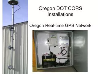
Oregon Real-time GPS Network www.TheORGN.net
Administrator • Oregon Department of Transportation • Geometronics Unit • Program Manager: Ron Singh • Technical Manager: Ken Bays • ORGN Support: Randy Oberg
Administrator Responsibilities • Network quality control • Network software operation • Network software maintenance and upgrades • User support
Major Cooperators & Support • NGS • UNAVCO Plate Boundary Observatory • Washington State Reference Network • Exchange of raw GPS data streams across the Columbia River. • California and Idaho as their networks develops
Partners • Partners will provide sites, GPS equipment, and other major infrastructure to the network. • Government agencies • Inter-Governmental Agreements • Private entities • Public-Private Partnerships
Subscribers • Anyone who is not a partner and wants access to RTK correctors data from the ORGN. • Must have rover account set up • No direct fee at this time • Online rover account application at www.TheORGN.net • May have minimal fee in future to cover operation, maintenance, and upgrades, but not to cover the build of the infrastructure of the network.
Can I Trust the ORGN for Accurate GPS Positions? Installation • Pre-testing of Positions • Extreme Care • Sturdy Antenna Mounts • Carefully Calculated Positions • Constant Monitoring of Antenna Positions • Precise Emphemeris used for Correctors
Site Criteria Standards • 60 Km Station Spacing • Satellite visibility: clear view of sky • No electromagnetic interference • Pre-installation data quality sets: 3 days of GPS data • Continuous power w/ backup • Internet connectivity