Download
1 / 20
200 likes | 421 Vues
VORTEX ROSSBY WAVES IN HURRICANES: THEIR IMPORTANCE FOR NUMERICAL WEATHER PREDICTION. Dr. Gilbert Brunet Recherche en Prévision Numérique (RPN) http://www.cmc.ec.gc.ca/rpn/ E-mail: gilbert.brunet@ec.gc.ca Meteorological Service of Canada Québec, Canada Collaborators:

E N D
VORTEX ROSSBY WAVES IN HURRICANES: THEIR IMPORTANCE FOR NUMERICAL WEATHER PREDICTION Dr. Gilbert Brunet Recherche en Prévision Numérique (RPN) http://www.cmc.ec.gc.ca/rpn/ E-mail: gilbert.brunet@ec.gc.ca Meteorological Service of Canada Québec, Canada Collaborators: Earth Simulator Center: W. Ohfuchi McGill University: Y. Chen, Y. Martinez and P. Yau RPN: M. Desgagné Acknowledgement to CFCAS European Geosciences Union, General Assembly NP5.01 Quantifying predictability Vienna, 29 April 2005
VORTEX ROSSBY WAVES IN HURRICANES: THEIR IMPORTANCE FOR NUMERICAL WEATHER PREDICTION Introduction • 1) Motivation • 2) Wave activity diagnostics of a simulated hurricane • 3) A grand challenge on the Earth Simulator: A Canada - Japan collaboration on high impact weather
A major technological transfer in 2005-06 at MSC: GLOBAL GEM GRID AT 35km with improved physics and cloud representation
Instantaneous precipitation rate (mm/hr) for the Operational GEM model A 5 day animation (20/01/2002 to 25/01/2002) (HR=100km, TR=45 min.) Acknowledgement to M. Roch and S. Bélair
Instantaneous precipitation rate (mm/hr) for the Meso-Global GEM model A 5 day animation (20/01/2002 to 25/01/2002) (HR=33km, TR= 15 min.) Acknowledgement to M. Roch and S. Bélair
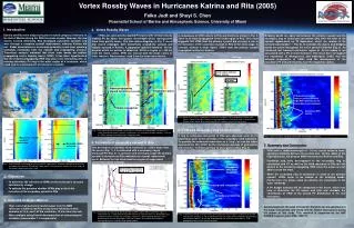
2) Wave activity diagnostics of a simulated hurricane Background and Motivation • Can-we characterize and quantify the dynamics and significance of the spiral bands? • Recent studies have shown that inner spiral bands have characteristics of vortex Rossby waves • Vortex Rossby waves (VRW) and gravity waves are mixed (Rossby number [U/Lf] is not small) • Apply Empirical Normal Mode (ENM) method to separate the waves to isolate the effect of VRW on a simulated hurricane -Chen and Yau 2001 (6 km grid size, 24 h simulation sampled every 2 minutes) Chen, Brunet and Yau 2003: Spiral Bands in a Simulated Hurricane. Part II: Wave Activity Diagnostics. Journal of Atmospheric Sciences: Vol. 60, No. 10, pp. 1239–1256.
Empirical Normal Mode (ENM) method • principal component (EOF) analysis • takes advantage of wave activity conservation law (e.g., EP flux) • decomposes simultaneously wind and thermal fields into dynamically consistent and orthogonal modes with respect to wave activities • used to study Rossby waves (Brunet 1994, Brunet and Vautard 1996, Zadra et al. 2002) and gravity waves (Charron and Brunet 1999)
00h 06h 12h 18h PV at 6 km
>0 <0 Basic State (24 hour mean) Potential Vorticity Radial Gradient Potential Vorticity
Wavenumber 2, PV ENM mode 1 and 2, spatial patterns Mode 2 cos Mode 1 cos Mode 1 sin Mode 2 sin
T=0.27h T=1h Wavenumber 2, ENM mode 1 and 2, time series 11.0% 10.5% |a|2 (10-3) (2 /24H)
00h 06h 12h 18h Period and variance (%) of most important ENMs that contribute to 47% of the total variance • NWP models with timestep less than one hour should start to resolve properly Vortex Rossby waves
Wavenumber 1 and 2, mode 1+2, EP flux (24h time mean) • Wave-mean-flow interaction diagnostic with E-P flux: 1~2 m/s per hour • Acceleration: low and middle troposphere inside/outside the eyewall • Deceleration: upper troposphere in the eyewall • Wave breaking signature
Hurricane Isabel north of Puerto Rico(on the 2003/09/12, 12:45 – 14:45 animation)GOES 12 visible image - Pixel size:1km Acknowledgement to Y. Chartier
First Conclusion • Analysis shows wavenumber 1 and 2 leading ENMs are vortex Rossby wave modes • The divergence (1~2 m/s per hour) of EP fluxes indicates that vortex Rossby waves play an important role in the intensification of the simulated hurricane • Wave breaking signature: i) The simulation is too dissipative (6km) ii) How generic and realistic this is? A full life cycle simulation that resolves convective scale is needed (1 km).
3) A Grand Challenge project on the Earth Simulator 964 hPa ET Phase 985 hPa Modelling the Full Lifecycle of Hurricane Earl at 1km Resolution with the Canadian MC2 Model Tropical Phase Class2 Hurricane September 1998: Classified as a very active TC period Desgagne, Ohfuchi,Brunet, Yau, McTaggart-Cowan and M. Valin, 2004: Large Atmospheric Computation on the Earth Simulator: A report on the LACES project. Annual Report of the Earth Simulator Center (April 2003–March 2004), 225-227. The Earth Simulator Center, Yokohama, Japan.
Grid Strategy for EARL on the ES: 3 Stages Rotated Mercator grids 50 km: 400 x 332 x 31 timestep - 240s, KFC 10 km: 1600 x 1260 x 41 - timestep 45s, KFC 1 km: 11007 x 8647 x 51 - timestep 6s, YAU Memory: 7 Tb CPUs: 22 x 180 (3960) Steps: 104400 X 6 sec. Wall clock: 7-8 days Outer 50 km grid: Initial and BCs from CMC analysis
Humidity at 350m height is shown over Gulf of Mexico for the first 18 hours of the simulation.-Only 1% of the simulation domain is shown!
Second Conclusion • NWP hurricane strategy at the Meteorological Service of Canada: - A full lifecycle reference simulation of hurricane Earl on the Earth Simulator for process studies. - We need to obtain good hurricane track predictions with meso-global GEM and 4D-VAR - Downscaling with nested and following coordinate GEM-LAM to obtain proper precipitation and intensity that depends on angular momentum transport, hence high resolution.