Download
1 / 20
200 likes | 329 Vues
This document explores the geological response of the Earth's mantle and crust under the load of a significant ice sheet, similar to the Antarctic ice sheet. It details a systematic approach to calculate pressure differentials resulting from ice and crust density, and how these pressures achieve hydrostatic equilibrium. The text also provides foundational knowledge on plate tectonics, landforms, and the continuous cycle of rock formation and destruction, emphasizing the processes that shape our planet's surface.

E N D
Large scale topographyTectonics and Structure www.montana.edu/kmw/
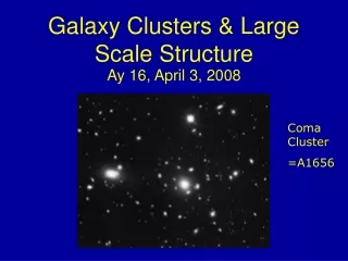
Response of the mantle and crust to loading: Lake Bonneville • http://geology.utah.gov/utahgeo/gsl/flash/lb_flash.htm • http://geology.utah.gov/utahgeo/gsl/flash/lb_flash.htm
Say an icesheet is 4000 m thick, (the Antarctican icesheet is roughly this thick at its maximum thickness.) • How far does the lithosphere deflect beneath the icesheet? • Step 1. Calculate pressure due to ice + crust • Step 2. Calculate pressure due to mantle + crust • Step 3. Pressures are equal due to hydrostatic equilibrium • Given, • ice has a density of 917 kg/m3 • crust has a density of 2700 kg/m3 • upper mantle (that gooshes out of the way to allow this deflection of the surface) has a density of 3300 kg/m3 • thickness of the crust beneath the center of the icesheet and the region outside of it is the same.
Brook manual, p. 2-4 • Q 2-3 • Magnetic declination: the difference between geographic north and magnetic north • Magnetic declination of Philipp quad= • 7.5 deg E • Verbal scale in in/mi • Philipp: 1” = 62,500” = .98mi • Kingston: 1” = 24,000” = .38mi • Verbal scale in cm/km • Philipp: 1 cm = .625km • Kingston: 1cm = .24 km
Brook manual, p. 2-10 • Q 2.6 • Horiz scale is • 1:25,000 or 1” on map = 25,000” on ground • Vert scale is • 1” = 100’ or 1”=1200” • VE=Horiz scale/Vert scale = • 25,000/1200=20.8 • Q 2.7 • Average gradient (or slope) = rise/run, in words • 500 ft/(520 yds x 3 ft/yd)=500 ft/1560 ft = 1 ft/3.12 • for every vert. ft of elev gain, the dist moved in 3.12ft
Rock Cycle Weathering, transport, deposition • Repeated creation and destruction of crustal material (rocks and minerals) • Volcanoes, folding faulting, uplift • bring rock, water, gas to the Earth surface • Rocks disintegrates • weathers by exposure to water and air • Transport by gravity, water, wind • weathering products go back to the ocean • Deposition and burial • formation of sedimentary rocks • Deep burial • metamorphic rocks • Uplift, intrusion, or extrusion • rocks exposed, process begins again
Landform creation by:Weathering, transport, deposition • Weathering agents move into soil and rock along a weathering front • brings fresh rock up • Weathered material (regolith; soil) on surface + material brought in by wind, water, ice, animals = weathered mantle • Mantle remains in place or moves downslope by gravity • water can also carry it downslope • wind can remove it
large scale features of the Earth are the product of tectonic process tekton, Gr. for mason or builder processes in the core and mantle => processes and structure in the lithosphere http://www.geosociety.org/gsatoday/archive/15/7/pdf/i1052-5173-15-7-4.pdf
Oceanic plate tectonics • Mid-ocean ridges: • the seams of a baseball • Volcanic eruptions produce new oceanic lithosphere • Cools, thickens, sinks http://www.pmel.noaa.gov/vents/nemo/education/images/plates_sm.jpg
Ocean landforms: Continental Shelf • The edges of the continents slope down from the shore into the ocean. • The part of the continent located under the water is known as the continental shelf. • In some places the continental shelf is fairly shallow and in other place it becomes very deep, but it is not the deepest part of the ocean.
Ocean Landforms: Continental Slope • The steep slope where the continental shelf drops to the bottom of the ocean floor is called the continental slope. • The depth of the ocean water increases greatly here.
Ocean Landforms: Mid-ocean ridge and Abyssal plain • On the bottom of the ocean, there is a central ridge, or mountain range, that divides the ocean floor into two parts. • These underwater volcanic mountains are known as the mid-ocean ridge.
Ocean Landforms: Trenches • There are many steep-sided canyons and deep, narrow valleys in the bottom of the ocean. • Ocean trenches are the deepest part of the ocean basin and are deeper than any valley found on land.
Ocean landforms: Guyots and Seamounts seamount http://www.utdallas.edu/~pujana/oceans/guyot.html
http://www.sanctuarysimon.org/monterey/sections/seamounts/project_info.php?projectID=100114&sec=smhttp://www.sanctuarysimon.org/monterey/sections/seamounts/project_info.php?projectID=100114&sec=sm
Brook, p 4-4 and 4-5 • Q 4.1(b) • Cones are associated with major river systems carrying high sediment loads • often formed at low stand (glacial times) • cones were then river deltas • Q 4.1 (c) • St Helena Island (15S, 5W); Easter Island (27S, 109W); Amsterdam Island (37S, 77E) • Islands, guyots, and seamounts were all formed at ocean ridges • The further it is from the ridge, the older it is • Q 4.2 (a) • Red Sea is the result of divergent plates under the continent • Arabian plate moving away from African plate • divergent plate boundary