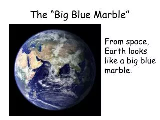
The Big Blue Marble
Compiled by Dr. Lorraine W. Hall 2005. The Big Blue Marble. GEOGRAPHY. ge·og·ra·phy (noun) 1. The study of the earth and its features and of the distribution of life on the earth, including human life and the effects of human activity.

The Big Blue Marble
E N D
Presentation Transcript
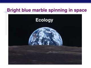
Compiled by Dr. Lorraine W. Hall 2005 The Big Blue Marble
GEOGRAPHY • ge·og·ra·phy (noun) 1. The study of the earth and its features and of the distribution of life on the earth, including human life and the effects of human activity. 2. The physical characteristics, especially the surface features, of an area.
GEOLOGY ge·ol·o·gy (noun) 1. The scientific study of the origin, history, and structure of the earth. 2. The structure of a specific region of the earth's crust.
TOPOGRAPHY Detailed description or graphic (picture) representation of a place or region on a map, a description of surface features. topos (Greek) = place graph (Greek) = draw or record
island A piece of land completely surrounded by water, islands are of four types: • Coral islands, formed by coral reefs • Barrier islands, formed by build-up of silt and sand • Volcanic islands, formed by oceanic volcanoes • Continental islands, those such as Tasmania that were once connected to a continent
archipelago a group or chain of islands clustered together in a sea or ocean
atoll a ring (or partial ring) of coral that forms an island in an ocean or sea. The protected area within the ring is a lagoon.
coral reef Coral reefs are found in warm, shallow, tropical seas, such as the South Pacific. Living coral -forming animals come in many colorful shades and magical forms, from fan shapes to brain coral. When the animals die, they leave limestone skeletons that form the foundations and ridges of coral reefs.
Post World War II Nuclear Experimentation on Bikini Atoll Operation Crossroads was an atmospheric nuclear weapon test series conducted in the summer of 1946 at Bikini Atoll in the Marshall Islands. The series consisted of two detonations, each with a yield of 21 kilotons, named shots ABLE and BAKER. The series was intended to study the effects of nuclear weapons on warships, equipment, and material.
The Initial Blast… At 0900 on 1 July, 1946, test ABLE detonated about 518 feet above the target fleet. The surface temperature of the resulting fireball was about 100,000 degrees Fahrenheit, scorching wood, paint and metal alike.
Bikini Atoll Operation Crossroads The cloud at its peak, shows the water column and the familiar cauliflower-shaped cloud of water vapor. Millions of gallons of water hung in the atmosphere, where they mixed with fission particles and became highly radioactive. The full formation of the BAKER cloud reached a height of 10,000 feet. The blast column reached to the floor of the lagoon--some 200 feet deep--and spewed bits and pieces of coral on the decks of the target fleet.
barrier islands As barrier islands disintegrate, the vast system of sheltered wetlands along coastal areas are exposed to increasing wave attack, salinity (saltiness), and storm surge. Removal of the barrier islands will accelerate destruction of wetlands which are nurseries for many species of fish and shellfish. The loss of the barrier islands and protected wetlands will have a profound impact on the fishing industry and the fragile coastal environment.
Barrier Islands act as a protection against storms and erosion to the continental coastline.
√ Quick Check √ • What is the difference between geography and geology as a study? • Name four major types of islands and describe how they are formed. • How might an area’s topography affect the lifestyle of a person living In that area? • Describe the events and motivation for the events on Bikini Atoll following WWII.
ocean A body of saline (salt) water occupying all or part of the Earth's ocean basins. There are five recognized oceans: the Pacific Ocean, the Atlantic, the Indian Ocean, the Southern Ocean, and the Arctic Ocean.
Did you know? • Oceans cover approximately 75% of the earth’s surface! No wonder early explorers used to think that the oceans formed the edges of the planet. • All the oceans are interconnected and have a salinity (salt content) of about 3.5% • At one time people thought the ocean floor was relatively flat. Not so. It has mountains valleys, plains, even sand dunes and canyons.
Which ocean is nearest your state? Arctic Atlantic Pacific Indian Pacific Southern
√Quick Check√ • Which Ocean lies between the Atlantic and Pacific and borders India? • What and where is the Mariana Trench? Describe how it was formed. • What provides the passageway between the Atlantic and Mediterranean Sea basins? • What and where is Telegraph Plateau? • What are four major threats to the health of our oceans?
The Pacific • Balboa discovered and named this ocean as it seemed very tranquil (pacific, like a pacifier) to him when he first saw it. Little did he know that the world’s tallest wave would be recorded here by a US Navy ship in 1933 at 112 feet tall! • It is home to the deepest point of Earth, the Mariana Trench off the southwest coast of Guam. At this point, the Challenger Deep is estimated to be 36,198 feet deep. That would cradle Mount Everest with more than a mile to spare!
Mariana Trench The Mariana Trench is located north of New Guinea in the Mariana Islands. The Mariana Trench is the deepest point on the Earth's surface. The deepest part is called the Challenger Deep. The Trench is about 36,000 feet below sea level, which is about 6.8 miles down. Compare that to Mount Everest, which is a little over 29,000 feet or 5.5 miles high.
The Atlantic Ocean The Atlantic, the second largest ocean, has relatively few islands, unlike the Pacific. Most of these are located in the Caribbean.
The Ocean Floor The Atlantic Ocean is separated from the Arctic Ocean by a submarine ridge extending from Greenland to Scotland; part of the floor (about 3,000 feet don) is known as “telegraph plateau” because of the network of cables laid there. A shallow submarine ridge across the Strait ofGibraltar separates the Mediterranean basin from the Atlantic and limits the exchange of water between the two bodies.
The Great Transatlantic Cable By the middle of the 19th century, a network of telegraph poles strung across America enabled Samuel Morse's invention to create communication between cities across the continent. Communicating with Europe was another matter. Messages to London were sent the old-fashioned way, aboard sailing ships that could take weeks to reach their destination. Though the need for a transatlantic cable was obvious, the physical challenges to laying one were enormous.
Telegraph Plateau The project would require the production of a 2,000 mile long cable that would have to be laid three miles beneath the Atlantic. Cyrus Field, a young New York paper manufacturer, took up the challenge. • After 12 years of cajoling investors, several failed attempts to lay the cable, and millions of wasted dollars, Field and his team of engineers finally succeeded. On July 27, 1866, when the wire was finally in place, Field sent back the first message to Europe: "Thank God, the Cable is laid." Since then, nothing has broken his communications link with Europe -- not storms, earthquakes or world wars.
Indian Ocean The Indian Ocean is the third-largest body of water in the world, covering about 20% of the Earth's water surface. The ocean's importance as a transit route between Asia and Africa has made it a scene of conflict.
Southern Ocean In 2000, the International Hydrographic Org. delimited a fifth world ocean - the Southern Ocean - from the southern portions of the Atlantic Ocean, Indian Ocean, and Pacific Ocean.It is the fourth largest ocean and, like the Arctic, a circumpolar body of water.
Arctic Ocean The Arctic Ocean surrounds the North Pole between North America and Eurasia. Located entirely within the Arctic Circle, the “Frozen Ocean” is covered by pack ice (2-14’ thick) year round in most of its central and western portions. From the fjords of west Greenland, dangerous icebergs (like the one that sink the Titanic) originate.
Some Deep Ideas Although man has walked upon the moon and photographed the craters of other planets, he still knows very little about the great oceans on our own earth. People who study the ocean are called oceanographers, while the study of the oceans is called_________________.
Our Oceans are at Great Risk • Increased pressures from unregulated and over fishing • Habitat destruction • Pollution • Introduction of invasive alien species • Global warming All of these threaten the diversity of life in estuaries, coastal waters and oceans, and the impacts could be devastating for life in the sea.
bay a body of water that is partly enclosed by land (and is usually smaller than a gulf).
This mid bay barrier in Narrabeen- Sydney (Australia), has blocked a former bay to form a lagoon.
bight A bight is a wide bay formed by a curve in the shoreline. Looking at a map of Australia's southern coastline, one can see the curve which creates this bight.
This is a photo of the Great Australian Bight. It is 685 miles across, from Cape Pasley in Western Australia to Cape Carnot in South Australia. Note the strata (layers) of rock.
gulf A gulf is a part of the ocean (or sea) that is partly surrounded by land and is usually larger than a bay. (Satellite image of Persian Gulf 1990)
Satellite Image of Middle East 2003Persian Gulf and Gulf of Aden
aquifer Coastal Aquifer in Iceland
river A large stream of water flowing in a bed or channel and emptying into an ocean, a sea, a lake or another stream; a stream larger than a rivulet or a brook. How many of the major rivers of the world can you name?
river basin River basin - The tract of country drained by a river and its tributaries.
The Nile River The Nile and its tributaries, or branches, flow though nine countries. The White Nile flows though Uganda, Sudan, and Egypt. The Blue Nile starts in Ethiopia. Zaire, Kenya, Tanzanian, Rwanda, and Burundi all have tributaries, which flow into the Nile or into Lake Victoria. It is over 4,000 miles in length.
The Nile Red squares are dams.
In ancient Egypt. . . The calendar was divided into three seasons, based on the flooding of the Nile. During the season of the Inundation, layers of fertile silt were deposited on the land. The Egyptian people were drafted to work on the pyramids and building projects during that time. Hapi – The Nile Deity