Download
1 / 24
250 likes | 422 Vues
Silk Roads: Trade and Travel Spread Cultural Ideas PART 1 - Background. Carol Gersmehl, carol.gersmehl@gmail.com Co-coordinator, New York Geographic Alliance PowerPoint prepared in cooperation with Marty Mater, Michigan Geographic Alliance

E N D
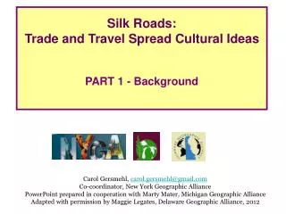
Silk Roads: Trade and Travel Spread Cultural Ideas PART 1 - Background Carol Gersmehl, carol.gersmehl@gmail.com Co-coordinator, New York Geographic Alliance PowerPoint prepared in cooperation with Marty Mater, Michigan Geographic Alliance Adapted with permission by Maggie Legates, Delaware Geographic Alliance, 2012
Silk Roads – Geographic Objectives Students will able to: • 1. Locate regions that were part of the Silk Road network (Mediterranean, Arabia, eastern Africa, Persia, Central Asia, India, and China) in 100 CE • 2. Describe physical conditions (deserts, mountains, rivers)at various places along the Silk Road. • 3. Identify important economic goods and cultural ideas(highly valued in 100 CE) that movedalong the Silk Road. • 4. Explain how trade and travel along the Silk Road changed places over time.
Silk Roads - Vocabulary Merchant Monk Bandit---------------------------------------------------------------- Silk cloth Glass Spices Heavenly horses Ivory Cotton cloth---------------------------------------------------------------- Buddhism Islam---------------------------------------------------------------- Caravan Bactrian camel Dromedary camel ---------------------------------------------------------------- Oasis Port city
Silk Roads - Resources This lesson is based on content found in The Silk Route, 7000 Miles of Historyby John S. Major Other books for children: -- We’re Riding on a Caravan, An Adventure on the Silk Road by Laurie Krebs -- Stories from the Silk Road by Cherry Gilchrist -- Caravan to America, Living Arts of the Silk Road by John S. Major & Betty J. Belanus (and forward by Yo-Yo Ma)
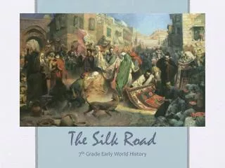
Facts about the trade network known as “The Silk Road” It was more than one road - actually a network of caravan routes that stretched across the continent. Developed over time by many traders and groups. Almost no one traveled the whole route. Most people bought and sold goods on either end of one segment of the route.
Animals Camels, horses, and ____ _______
People Bandits and Monks
Places Mountains, Deserts, Oases (plural of oasis)
Silk Road towns connected the largest citiesof the West and East in 100 CE. West East
Students may use this map to see Silk Roads townsbetween China and the Mediterranean Sea. West East
Our Silk Roads journey starts in China. Between Chang’an (#1) and Dunhuang (#4): Bandits from Mongolia or Tibetmay attack caravans.Therefore, Chinese soldiers must travel with the caravans. In the Chinese city of Chang’an (#1), merchants load fine silk clothand herbal medicines ontotwo-humped Bactrian camels.
We will explore the Silk Roads using a satellite image.Find dry areas near the numbered Silk Road towns. In this satellite image,the green color tells us about vegetation. Green areas have enough waterfor trees and crops. Which colors indicate drier areas or deserts? tan
Dunhuang(#4)is an importantBuddhist religious center. Buddhist monks traveled along the Silk Roadand brought Buddhismfrom India to China.
TaklamakanDesert(“if you go in, you won’t come out”):Caravans must travel through this desertbefore the heat of summer hits. Find #5, #6, #7, #8, #9.
Oasis towns are located along theedge of the Taklamakan Desert. Rivers carry melted snow down from high mountains! High, snow-covered mountains surround theTaklamakan.
Kashgar (#10) is an oasis town,where local merchants trade their dates, melons, and grapesfor silk that the caravans bring from China. Why did the Chinese travel this far west (to Central Asia)? PamirMountains (between #10 and #13): The route continues through mountainsand is called the “Trail of Bones”because the route is dangerouslysteep and cold.
PamirMountains: Between Kashgar (#10) and Tashkent (#13),caravans climbed the“Trail of Bones” throughthe high, steep Pamirs. The highest elevations are purpleand dark gray. PamirMountains: Elevations are above 10,000 feet.It is extremely cold, and there is no food.
Why cross the Pamirs? The highest elevations are purpleand dark gray.
In Tashkent (#13), Chinese military use silkto purchase the strong horsesraised in the grasslandsof Central Asia. In Tashkent(#13),local merchants also sellfine locally made wool carpetsas well as musical instrumentsand glass objectsthat have come fromEurope and the Middle East.
Dromedary camels from Arabiaare usedfrom here westward. #20 and #21 sendspices and cotton cloth from Indiaand precious stones from Ceylon. In Herat(#17),a great Islamic mosque stands near the city market.People from Arabia brought the religion of Islamto Silk Road towns.
Tyre (#27): Goodsare loaded onto ships in this port city on the Mediterranean Sea. In Baghdad(#24),ivory, gold, and spices from Africaand pearls from the Persian Gulfare exchanged for silk. In Byzantium (#28),few people know where China is,but wealthy people want the silk that has traveledalong the Silk Roads.
Silk Road towns connected the largest citiesof the West and East in 100 CE.
Silk Road towns connected the largest citiesof the West and East in 800 CE.
Thanks to all of our collaborators! Michigan Geographic Alliance New York Geographic Alliance Carol Gersmehl, carol.gersmehl@gmail.com Co-coordinator, New York Geographic Alliance PowerPoint prepared in cooperation with Marty Mater, Michigan Geographic Alliance