Conceptual Model of Groundwater Flow System with Recharge Playa Layers
Explore an online conceptual model from USGS Hydrologic Atlas portraying the recharge dynamics of groundwater flow in a layered system. Understand dry cell issues, re-saturation challenges, leakance, and calibration targets.

Conceptual Model of Groundwater Flow System with Recharge Playa Layers
E N D
Presentation Transcript
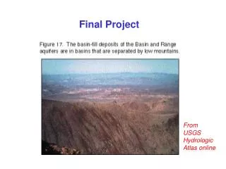
Final Project From USGS Hydrologic Atlas online
Conceptual Model of the flow system Recharge Recharge Playa
Layers The problem of dry cells and re-saturation Layer 1 Datum Layer 2 50 ft gap represents confining bed Layer 3 – variable bottom
from GWV Layer 1 = type 1 Layer 2, 3 = type 3
Leakance between layers where each Layer belongs to a different hydrogeologic unit Layer 1 leakance See A&W, p. 81
Leakance “Quasi 3D” model Layer 2 leakance See A&W, p. 81
Conceptual Model of the flow system Recharge Recharge Playa
QET = RETMxy [h - (hs-d)] / d ET for h hs-d and h < hs RETM is the maximum ET rate, which occurs when h = hs. d extinction depth h hs
QET = QETM at the land surface. QET = 0 below the extinction depth.
Calibration Targets associated error calibration value 0.80 m 20.24 m Target with smaller associated error. Target with relatively large associated error.