Surface circulation
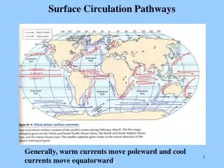
Surface circulation. Wind driven, Coriolis modified Ekman and geostrophic flow. Surface currents - patterns. Similar in all basins At low latitudes, have large, “closed” gyres Gyres elongated in the E-W direction Gyres centered on the subtropics (~30 o N or S)

Surface circulation
E N D
Presentation Transcript
Surface circulation Wind driven, Coriolis modified Ekman and geostrophic flow
Surface currents - patterns • Similar in all basins • At low latitudes, have large, “closed” gyres • Gyres elongated in the E-W direction • Gyres centered on the subtropics (~30oN or S) • West-directed flow at N and S equatorial currents • East-directed flow ~ 45oN and S • N-S directed flow at eastern and western boundary currents
Surface currents - patterns • West-directed flow driven by tradewinds (coming from N or S-east • East-moving equatorial countercurrents • Western boundary currents are distinct, narrow (< 100km), swift (>100 km/day) and deep (2 km) • Eastern boundary currents are broad (>1000 km), weak (~10s km/day) and shallow (~500 m) • Have smaller, less developed polar gyres in N • Have circumpolar “gyre” in the S
Transverse currents • E-W currents driven by the trade winds (easterlies) and mid-latitude westerlies • Link the boundary currents • Equatorial currents • Moderately shallow and broad • Pile up water on west side of basin (W Atl is 12 cm [8”] higher than Pac; W Pac is 1 m higher than E Pac) • Eastward flowing currents at mid-latitudes are weaker (wider and slower) than equatorial currents • Differences in land mass distribution in N and S hemispheres affects flow
Change in productivity rates affects atm CO2? Assume these fluxes are balanced Change in burial rates affects atm CO2? Why is this important? Processes in surface, wind-driven layers are different but connected to processes in deep waters. Fig. 8-9
Short-term Long term (organic) Long term (inorganic/tectonic)
Link with short term C cycle In surface oceans “adds” back CO2 Onset of modern plate tectonics “turns this on”
Thermohaline circulation • Vertical water movement • Driven by density differences (can be very small) • Remember temperature and salinity diagrams and the properties of water • Temperature and salinity profiles (with depth) • Salty water is denser than fresh water • Cold water is denser than warm water • Density gradients with latitude (due to temperature differences of surface waters) • Polar water has the most uniform density (weakest pycnocline) so is least stable
Polar water column is • least stable; most • uniform density • weakest pycnocline • Surface is cold • Deep water is cold • everywhere • Easiest to rearrange • Formation of ice • excludes salt • Seawater freezes at • –2oC
Cooling Cycle: 1. August 2. September 3. October 4. November 5. January Warming Cycle: 1. March 2. May 3. June 4. August
Most of the ocean is cold Temperature degree C
Thermohaline circulation • As for the atmosphere, there are convergence and divergence zones where water masses collide or diverge • Important for global heat balance • Deep circulation and basin exchange of water, material, and heat
Thermohaline circulation • Deep circulation is driven by density differences • Horizontal movement along density surfaces • Movement is very slow (0.1 m/s) • Three layer ocean • surface mixed layer • Pycnocline • Deep water • Deep water formed at 2 places – N Atlantic and Weddell Sea (Antarctica) • Connection between surface and deep water • Diffusion (slow and along density gradients) • Mixing (e.g., storms) • Upwelling (polar, equatorial and coastal)
Deep circulation is like a conveyer belt that moves heat and water
Water masses • Possess identifiable properties • Don’t mix easily – flow above or beneath each other • Surface water – to about 200 m • Central water – to bottom of main thermocline • Intermediate water – to about 1500 m • Deep water – to about 4000 m (not the bottom) • Bottom water – in contact with seafloor • Retain characteristics when the mass was formed at the surface (heating/cooling, evaporation/dilution)
Formation of deep water • Antarctic bottom water – densest water in the ocean – S (34.65%o), T (-0.5oC), dens (1.0279) • Weddell Sea in winter – when ice freezes and get brines • Sinks and creeps North • Pacific and Atlantic – 100’s to 1000’s of years to get to northern basin • North Atlantic deep water • Formed in the Arctic but escapes only through channels • Warm, salty water chills (heat is transferred to air) • Atlantic and Pacific deep water is less dense than Antarctic bottom water
Mediterranean deep water • Salty water (38 %o) • Underlies central water mass in Atlantic • Warmer than other deep water so not as dense
Different combinations of temp and salinity can make water of the same density • Isopycnal is a line of constant density • Mixing of water masses can increase the density Increasing density
Age of a water mass • Oxygen and C isotopes • Water picks up oxygen and CO2 only at surface by exchange with atmosphere • Loses oxygen as it ages (respiration, reaction with rocks); 14C decays as it ages • Water masses mix slowly • Antarctic bottom water in the Pacific retains its character for up to 1600 years
-70‰ ∆14C -230‰ -110‰ -210‰ -150‰ -170‰ -150‰ -170‰ This diagram represents the flow at a depth of 4000 m; the strange-looking continent/ocean configuration is what we would obtain if the oceans were drained to this depth. (After W.S. Broecker and T.-S. Peng, Tracers in the Sea, New York: Eldigio Press, 1982, Figure 1-12.)
Water residence time • Bottom currents are slow • Antarctic bottom water ~1600 years • Other bottom water – 200-300 years (time it takes to rise to the surface) • Fast bottom currents on bottom around objects • Surface currents are faster • Surface water – on the order of years • N Atlantic gyre may take about 1 year to complete a circuit
Deep water circulation • Flow may be slow but still modified by Coriolis
Convergence zones • Two water masses meet • Usually one will go under the other (density) • If the same density, may mix to create a new and denser water mass (remember T-S diagram) – this is caballing • Formation of N Atlantic intermediate water, Antarctic intermediate water and Antarctic bottom water produced by mixing
S-curve tracks density • with depth • Points a and b on an • Isopycnal so are the • same density, despite • different temperatures • and salinities • If the two water masses • mix, will result in • denser water!
Convergence zones • Areas of downwelling • Antarctic convergence zone at 50-60oS • South of this is the Antarctic Circumpolar Current • Subtropical convergence zone (40-50oS) • N boundary of Subantarctic Surface Water • Equatorward of subtropical convergence zone is Central Water which is the warmest and saltiest water • Subtropical convergence (45-60oN) • Arctic convergence – ill-defined because of land mass in the N
Divergence zones • Areas of upwelling • Tropical divergence • Antarctic divergence
Upwelling • Sinking water must be offset by upwelling of water • Water sinks in a localized area, relatively rapidly • Water rises gradually over larger areas • When water moves to surface, must be transported to a pole to sink again • Diffuse upwelling maintains a permanent thermocline (1 cm/d)
Maintained by diffuse upwelling
Thermohaline flow • Sinking of surface water most pronounced in the North Atlantic • Water moves at great depths toward Southern hemisphere and wells up into the surface in the Indian and Pacific Oceans (~1000 years) • Slow circulation that crosses hemispheres superimposed on rapid flow of surface water in gyres • Some heat travels from S Pacific, across Indian Ocean and into the Atlantic • Flow distributes gases, solids, nutrients and organisms among ocean basins
The Redfield Equation 106 CO2 + 16 NO3- + HPO42- + 122 H2O (CH2O)106(NH3)16(H3PO4) + 138 O2 Can also develop similar ratios for trace elements required for growth (e.g., Fe, Mn, Zn, etc.)