Navigating Data Sharing Challenges in GIS: Formats, Access, and Metadata Considerations
In the realm of GIS, effective data sharing is crucial yet complex. Various types of data require the right themes, accuracy, and formats, each posing unique challenges. From vector formats like shapefiles to raster formats such as TIFF, understanding data storage and accessibility, whether through local files or cloud services, is essential for efficient use. Despite the promise of the cloud for universal access and high performance, issues of compatibility and speed persist. Additionally, proper metadata, including standards like ISO 19115, enhances data reliability and usability.

Navigating Data Sharing Challenges in GIS: Formats, Access, and Metadata Considerations
E N D
Presentation Transcript
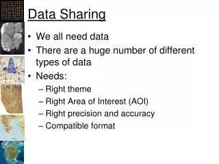
Data Sharing • We all need data • There are a huge number of different types of data • Needs: • Right theme • Right Area of Interest (AOI) • Right precision and accuracy • Compatible format
Challenges • Performance: • Local will always be faster • GIS datasets can be huge • Projection on the fly is slow • Formats: • New ones are typically too complex • Documentation • Typically the data is available with little documentation • Little or none on accuracy and precision
Vector Data Formats • Point-Specific Formats • Tab-delimited Text • Comma separated values • General Vector Formats • Shapefiles: Really popular • Coverages: Going away? • SDTS: Future uncertain at best? • Scalable Vector Graphics: Can be georeferenced • KML: Widely used, becoming a GIS standard, still not geo-referenced
Raster Formats • Imagine: IMG • Tagged Image File Formats: TIFF • ASCII Grid: Widely used • Ersi Grid: Being replaced by IMG? • JPG: Georeferenced with world file and prj • BIL, BIP, BSQ: and other “binary” formats • All have a “header” file (HDR)
Hierarchical Data Formats • Hold the promise of a single “self-describing” data file • So far the promise has not been met • NetCDF converters now in ArcGIS • Examples: • Hierarchical Data Format: HDF • Network Common Data Form: netCDF
Computer-Based Data Storage • Computers have 2 places to store data: • Dynamic Random Access Memory (RAM) • “In Memory” • Goes away when the power goes off • “Static” RAM, Disks, Tapes • “In Files” • Does not go away when the power goes off • Goes away when your “disk” crashes • Examples • Memory/Thumb “sticks” • Network drives • Local drives • “Floppy” discs
GIS Data Access • In Memory • Loaded in ArcGIS • In File • Traditional Files: • Shapefiles, TIFF, IMG, MXD, EOO, PRJ… • Network Files: • Links to download • Web services • Databases
Promise of the “Cloud” • What is the cloud? • Lots of servers on the Internet providing “services” • Promise: • Universal access to data • High-performance • High-quality • Reality: • Lots of problems with compatibility • Typically slow • Questionable to undocumented quality
The Cloud • Esri’s Backgrounds • Great if you use the background’s spatial reference and have strong Internet connection • Problems: • Cut-off labels • Projecting on the fly • Slow Internet connection
ArcOnline • GIS Is Moving Into the “Cloud” • Your data will be stored on other companies servers • You’ll use web applications to access, analyze, distribution, and publish your data! • Thoughts?
What works • Large datasets on your workstation • Serving data on servers • Scripts to download, process data • Web services for frequent, small transfers (scripted)
Shared Storage Successes • Shared network drive • Can be on a workstation • Define the folder organization! • Make sure it is backed up • DropBox for Teams • Maintains local copies • Trying it out with OSU/DOE research team
Metadata • ISO 19115:2003 • Geographic information - metadata • The Federal Geographic Data Committee (FGDC) • Content Standard for Geospatial Metadata • Being superseded by North American Profile (NAP) of ISO 19115:2003 • ISO/TS 19139:2007 • XML Implementation of ISO 19115
ArcGIS • Maintains their own metadata format • Import/Export to and from other formats • ArcToolbox -> Conversion Tools -> Metadata • ArcMap -> Customize -> Options • Changes the required fields
Jim’s Recommendation • Use and contribute to a “Directory of GIS Web Resources” • See ibis.colostate.edu (coming to HSU soon) • When publishing data: • Add at least the required metadata (including accuracy and precision) • Publish on simple web page with links to zipped data in common file formats