Download
1 / 12
120 likes | 155 Vues
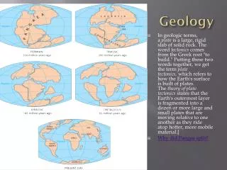
Discover Virginia's diverse physiographic provinces - Coastal Plain, Piedmont, Blue Ridge, Valley and Ridge, and Appalachian Plateau - each with unique characteristics shaped by geological processes. Explore the significance of watersheds in managing water resources sustainably and preserving the natural environment. Learn about the distinct geological features, including fault lines, mountain ranges, and fossil formations found in Virginia's varied landscapes.

E N D
Physiographic provinces • There are five physiographic provinces in Virginia. Coastal Plain, Piedmont, Blue Ridge, Valley and Ridge, and the Appalachian Plateau. • Each physiographic province has its own characteristics.
Coastal Plain • Closest to the beach • western border is the fault line • eastern border is the Atlantic Ocean • flat low-lying area with swamps and marshes • made mostly of sedimentary rock from the erosion of the Appalachian Mountains • Most fossils are of marine organisms which means that large areas of Virginia were covered in seawater
Piedmont • largest province • fault line is to the east • Blue Ridge is to the west • made of igneous and metamorphic rock. • Fall line – a narrow zone of small waterfalls and rapids • found as the border between the coastal plain and the piedmont provinces
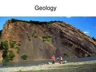
Blue Ridge • includes the Blue Ridge Mountains • folded and faulted mountains that are thickly forested • highest point in Virginia is Mount Rogers • Made of igneous rocks • Fossils can be found here of marine animals because these rocks were once under water
Valley and Ridge • includes most karst topography • made of limestone • parallel ridges and valleys • used mostly for farming • Fossils from the Paleozoic, Mesozoic and Cenozoic eras are found here
Appalachian Plateau • most mining of coal is done here • relatively flat but can be hilly and rugged
Virginia Watersheds • A watershed, or drainage basin, is the land area which contributes water to a stream, lake, river, wetland, or groundwater. • Managing water resources on a watershed basis makes good sense - environmentally, financially, and socially. • Watersheds are defined by natural hydrology, not political boundaries, and represent the most logical basis for managing water resources.
Watersheds of Virginia • We live in the Chesapeake Bay watershed. • Virginia is also in the Mississippi watershed which ultimately flows into the Gulf of Mexico . • Some water flows into the Atlantic Ocean as it goes into North Carolina.