Download

1 / 18
180 likes | 198 Vues
Explore scarce surface wind data from Nares Strait with a focus on extreme wind events in numerical simulations and historical expeditions. Learn how the strong boundary-layer stratification influences wind behavior in this unique environment.

E N D
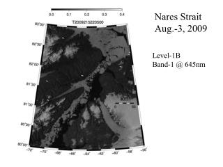
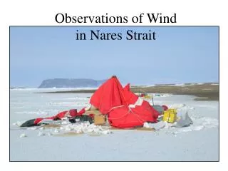
There is incidental evidence that winds are strong … but how strong?And why? Observations of surface wind are very sparse 3 November 2006 01:06 UTC
Numerical simulation demonstrates that wind along the strait increases with end-to-end sea-level pressure drop High terrain in northern Canada & Greenland can facilitate a close juxtaposition of disparate SLP anomalies – here 41 mb 3 November 2006 00:00 UTC
Surface weather has been routinely observed by field teams operating from PCSP camps along Nares Strait 1974-1990 Primarily during late spring & summer Only 2x per day
But no extreme winds were reported Maximum 19 m/s Rare above 15 m/s Perhaps lack of strong winds reflects indolence?
The only other observations were made by 19th century explorers at several over-wintering sites Hall Expedition, Polaris Bay November 1871 – August 1871 Hall Expedition, Life Boat Cove November 1872 – May 1873 Lady Franklin Bay Expedition Fort Conger (Greely during IPY) August 1881 – July 1883 24x per day
Wind topped 20 m/s once or twice per week, especially during the winter months 6 November 1871 to 31 August 1872
The maximum hourly speed was about 35 m/s (68 kt)… but stronger winds were missed for operational reasons • Strongest & most common winds blew along the strait • Speed histogram was strongly skewed • < 5 m/s for 65% of the time • > 20 m/s for 5% Polaris Bay 6 November 1871 to 31 August 1872
Most of the net atmospheric displacement occurred during winter 6 November 1881 to 31 August 1882
Wind speed at Fort Conger, Discovery Harbour Wind topped 20 m/s only twice in 2 years 15 August 1881 to 31 July 1883
The strongest winds were aligned with Nares Strait • Direction histogram reflects local terrain • Speed histogram is strongly skewed • < 5 m/s for 95% of the time Discovery Harbour 15 August 1881 to 31 July 1883
Wind speed at Polaris House, Life Boat Cove Wind topped 20 m/s infrequently, but low wind speed was uncommon 1 November 1872 to 31 May 1873
The wind regime was dominated by north-easterlies from Kane Basin • Strongest winds blow along the strait • Average wind speed is high • Speed histogram is bi-modal Polaris House 1 November 1872 to 31 May 1873
Histograms of along-channel airflow suggests two regimes of wind Atmospheric modeling has revealed strong correlation between along-strait airflow & SLP difference. Samelson et al. (2006) 1) Light winds dominate to a degree varying with season & site 2) Occasional very strong winds follow the Strait Alert minus Carey Islands
These observations suggest an important role for boundary-layer stability The incidence of light wind at Polaris Bay was much higher than the likely incidence of weak along-channel pressure gradient This suggests a non-linear response of surface wind to pressure forcing The most likely cause of non-linearity under weak forcing is stable stratification of the atmospheric boundary layer This prevalent condition is known as the Polar Inversion. Potential temperature may increase by 20°C in the lowest 300 m of the atmosphere Contributing factors are atmospheric subsidence (adiabatic heating), cloud-free skies, strong long-wave radiative heat loss from the high emissivity snow-surface & weak insolation The resulting stratification in potential density suppresses turbulence generated by shear in airflow near the ground In consequence, momentum is not mixed down to the surface and ground-level wind remains light
Strong boundary-layer stratification decouples airflow aloft from surface friction (for a while) Air flow through Nares Strait is not subject to geostrophic control on a synoptic scale Suppression of boundary-layer turbulence permits continued acceleration of airflow aloft Acceleration continues until shear production of TKE via free-stream instability (e.g. KH) overcomes buoyancy suppression The atmospheric boundary then becomes turbulent, first intermittently and then explosively as eddies bring high-speed air to the surface
The implied sudden onset of extreme wind from calm is consistent with events at Lafayette Bay in April 2005 • … and with a composite of windstorms measured at Polaris Bay during the winter of 1871-1872
Factors influencing the Polar Inversion affect the wind climate of Nares Strait Snow cover (through surface emissivity) Cloudiness (through down-welling long wave radiation) Solar season Lateral & vertical (viz. subsidence) advection of warm air aloft Nares Strait may harbour a unique wind regime, by virtue of: Its great length (550 km) Its high relief (2000-3000 m) Its strong boundary-layer stratification (Polar Inversion) Its lack of a diurnal cycle in B-L stratification in winter