Download
1 / 49
490 likes | 611 Vues
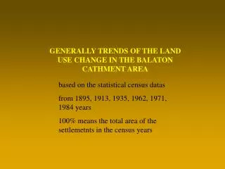
GENERALLY TRENDS OF THE LAND USE CHANGE IN THE BALATON CATHMENT AREA. based on the statistical census datas from 1895, 1913, 1935, 1962, 1971, 1984 years 100% means the total area of the settlemetnts in the census years. 100%. 50%. 25%. 5%. Forest in. 1895. 100%. 50%. 25%. 5%.

E N D
GENERALLY TRENDS OF THE LAND USE CHANGE IN THE BALATON CATHMENT AREA based on the statistical census datas from 1895, 1913, 1935, 1962, 1971, 1984 years 100% means the total area of the settlemetnts in the census years
100% 50% 25% 5% Forest in 1895
100% 50% 25% 5% Forest in 1913
100% 50% 25% 5% Forest in 1935
100% 50% 25% 5% Forest in 1962
100% 50% 25% 5% Forest in 1971
100% 50% 25% 5% Forest in 1984
100% 50% 25% 5% Garden, and orchard in 1895
100% 50% 25% 5% Garden, and orchard in 1913
100% 50% 25% 5% Garden, and orchard in 1935
100% 50% 25% 5% Garden, and orchard in 1962
100% 50% 25% 5% Garden, and orchard in 1971
100% 50% 25% 5% Garden, and orchard in 1984
100% 50% 25% 5% Non cultivated area (mainly built up areas and roads) in 1895
100% 50% 25% 5% Non cultivated area (mainly built up areas and roads) in 1913
100% 50% 25% 5% Non cultivated area (mainly built up areas and roads) in 1935
100% 50% 25% 5% Non cultivated area (mainly built up areas and roads) in 1962
100% 50% 25% 5% Non cultivated area (mainly built up areas and roads) in 1971
100% 50% 25% 5% Non cultivated area (mainly built up areas and roads) in 1984
100% 50% 25% 5% All cultivated area in 1895
100% 50% 25% 5% All cultivated area in 1913
100% 50% 25% 5% All cultivated area in 1935
100% 50% 25% 5% All cultivated area in 1962
100% 50% 25% 5% All cultivated area in 1971
100% 50% 25% 5% All cultivated area in 1984
100% 50% 25% 5% Reed in 1895
100% 50% 25% 5% Reed in 1913
100% 50% 25% 5% Reed in 1935
100% 50% 25% 5% Reed in 1962
100% 50% 25% 5% Reed in 1971
100% 50% 25% 5% Reed in 1984
100% 50% 25% 5% Pasture, meadow in 1895
100% 50% 25% 5% Pasture, meadow in 1913
100% 50% 25% 5% Pasture, meadow in 1935
100% 50% 25% 5% Pasture, meadow in 1962
100% 50% 25% 5% Pasture, meadow in 1971
100% 50% 25% 5% Pasture, meadow in 1984
100% 50% 25% 5% Arable land in 1895
100% 50% 25% 5% Arable land in 1913
100% 50% 25% 5% Arable land in 1935
100% 50% 25% 5% Arable land in 1962
100% 50% 25% 5% Arable land in 1971
100% 50% 25% 5% Arable land in 1984
100% 50% 25% 5% Vineyard in 1895
100% 50% 25% 5% Vineyard in 1913
100% 50% 25% 5% Vineyard in 1935
100% 50% 25% 5% Vineyard in 1962
100% 50% 25% 5% Vineyard in 1971
100% 50% 25% 5% Vineyard in 1984