Download
1 / 13
130 likes | 276 Vues
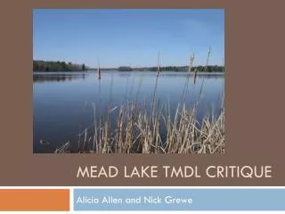
Complexities of the Carters Lake TMDL. 26th Annual Alabama Water Resources Conference September 6, 2012. Presented by: Jeremy Wyss, H.I.T. Tetra Tech. Carters Lake System. Headwaters of Coosa River. ≈520 Square Miles. Tallest Earthen Dam East of Mississippi River. ≈450 feet deep.

E N D
Complexities of the Carters Lake TMDL • 26th Annual Alabama Water Resources Conference • September 6, 2012 Presented by: Jeremy Wyss, H.I.T. Tetra Tech
Carters Lake System Headwaters of Coosa River ≈520 Square Miles Tallest Earthen Dam East of Mississippi River ≈450 feet deep USACE Peak Power Pump Storage Operation
Watershed Standards Coosawattee River at Georgia Highway 5 near Ellijay • TP – 151,500 pounds/year Mountaintown Creek at State Road 282 (US Hwy 76) near Ellijay • TP – 8,000 pounds/year
Lake Standards Whole Lake (Elevation 1072) • pH 6.0 – 9.5 • TN 4.0 mg/L in photic zone • TP 172,500 lbs or 0.46 lb/acft • DO 5.0 mg/L (daily average) not less than 4 mg/L Upper Lake - CoosawatteeRiver Embayment Mouth • Chlorophyll a 10 µg/L (growing season average) Mid Lake - Upstream from Woodring Branch • Chlorophyll a 5 µg/L (growing season average)
Carters Modeling Models Outputs Carters Watershed Subwatershed Flows Subwatershed Concentrations (Chl-a, TN, NH3, NOx, OrgN, TP, PO4, OrgP, BOD5, DO, Temp, TSS) LSPC Flows Temperatures Concentrations Water Surface Elevation Temperature and Dissolved Oxygen profiles Lake Concentrations (Chl-a, TN, NH3, NOx, OrgN, TP, PO4, OrgP, BOD5, DO, Temp) Carters Lake EFDC Re-Reg Lake EFDC Re-Reg Watershed LSPC
Model Scenarios Baseline • Model Calibration Full Permit • Point Sources and Water withdrawals at full permit No Point Sources • Point Sources and Water withdrawals removed All Forest (natural) • All land use area converted to Forest Future Land use • Land use processed with GLUT 2040 Reductions • Land use and point source % reductions
TMDL Status • Modeling and scenario runs are completed (GAEPD reviewing) • GAEPD/EPA looking into standard modifications • Mountaintown Creek Total Phosphorus • Lake Total Nitrogen • Chlorophyll a • GAEPD looking into standard establishment • Talking Rock Creek • Reregulation Reservoir • Georgia Department of Natural Resources Board this fall
Next Steps • Get TMDL approved • Incorporate modeling results into Georgia State Water Plan • Link Carters modeling to the GSWP Coosa River Basin model • Investigate impacts on Coosa and Lake Weiss TMDL’s
Complexities of the Carters Lake TMDL Comments/Questions? Acknowledgements Dr. Elizabeth Booth, GAEPD