Water Resource Management in the Overexploited Melian Basin, Tunisia: A Case Study
This case study focuses on the Melian basin in Tunisia, emphasizing water resource management challenges and strategies. With an area of 553 km² and a population of 390,000, the basin features a dense drainage network, two reservoirs, and 2,500 wells. However, groundwater exploitation has reached 150% of sustainable levels, leading to quality deterioration. This document discusses complex management issues, external dependency on water imports, and offers recommendations for optimization, including new treatment plants and artificial recharge initiatives.

Water Resource Management in the Overexploited Melian Basin, Tunisia: A Case Study
E N D
Presentation Transcript
OPTIMA PROJECT Fourth Management Board Meeting December 19-20, 2006 Milano Tunisia case study CNTD-2006
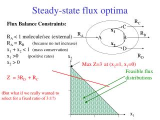
CASE STUDY • Water use • Domestic • Industry • Agriculture Melian basin Increase • Area = 553Km² • Population = 390 000 inhabitants • 4 subcatchments • Dense Drainage network Nodes • 2 reservoirs • 26 mountain lakes • 2500 wells Aquifer • Lithology = Plio-quaternary • Groundwater storage = 27.31 MCM/ year • Exploitation = 28.1 MCM / year • Nbre of Bore holes = 494 • State = overexploited Case study: Melian basin, TUNISIA CNTD-2006
RIVER BASIN DATABASE CNTD-2006
ECONOMICS CNTD-2006
DEMOGRAPHY CNTD-2006
INSTITUTIONS CNTD-2006
DEMAND CNTD-2006
RAINFALL- RUNOFF MODEL CNTD-2006
WATER RESSOURCE MANAGEMENT MODEL(WRM) CNTD-2006
DATA COLLECTED Irrigation Districts CNTD-2006
DATA COLLECTED Water consumption volume per use (1000 m3 )- year 2000 CNTD-2006
DATA COLLECTED Aquifer parameters CNTD-2006
DATA COLLECTED • Collection of 2500 wells built in the case study: complete information is available concerning: wells depth, diameter, usage, exploitation, equipment, standing water level, dry residue… • Dams: name, coordinates , sector, year of construction, storage capacity, irrigated area, inflow water, name of catchment… • Collection of historic data related to the wells’ observation in the groundwater • Mountains Lakes: name, coordinates, realization year, name of catchment, area of the catchment, storage capacity, delegation… • Observation well: name, coordinates, year, dry residue, standing water level… • Collection of hydrologic, hydrogeologic and economic data CNTD-2006
WATERWARE NODES CHART CNTD-2006
NEW TOPOLOGIC MODEL Demand node M’chergua reservoir End node Start node Melian basin TP Melah basin Reservoir node Medjerda canal Rmel basin Hma reservoir GW-SONED El Gola-SONED Irrigation Hma basin Domestic GW Industry TP Sea CNTD-2006
Implementation of WRM model CNTD-2006
DOMESTIC NODE CNTD-2006
IRRIGATION NODE CNTD-2006
BIR M’CHARGUA RESERVOIR CNTD-2006
EL HMA RESERVOIR CNTD-2006
GROUNDWATER CNTD-2006
MIOCENOUS GW CNTD-2006
OLIGOCENOUS GW CNTD-2006
PLIO-QUATERNARY GW CNTD-2006
WRM RESULTS CNTD-2006
WRM RESULTS (2) CNTD-2006
WRMECONOMIC RESULTS CNTD-2006
PROBLEMS RELATED TO OUR CASE STUDY • Water supply is very dependent on the external importations of water • Water management in the basin is very complex because of the multitude of stakeholders involved in water issues • Drainage of used water (from sabkhat sijoumi) into the Melian basin is causing pollution into marine environment • The runoff in the Melian basin is very low • The groundwater is overexploited (150%), this situation leads to the deterioration of the groundwater quality CNTD-2006
WATER RESOURCES OPTIMIZATION • Reduce the water exploitation of the groundwater • Creation of a new treatment plant in the area to exploit the treated water for irrigation • Restoration and rehabilitation of Sabkhat Sijoumi by ONAS (The National Sanitation Board ) • Increase of the groundwater quantity by artificial recharge coming from surface water that is not exploited at present CNTD-2006
THANK YOU FOR YOUR ATTENTION CNTD-2006