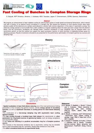
Applications of Linked Geospatial Data for Real-Time Fire Monitoring
The presentation outlines various applications of linked geospatial data, particularly in fire monitoring. It highlights systems like Linked Sensor Middleware and TELEIOS, which utilize RDF stores and Semantic Web technologies to enhance real-time data collection, processing, and mapping of fire incidents. The study discusses the integration of Earth observation images, fire monitoring products, and auxiliary geo-information, ensuring reliable decision-making through high-accuracy fire product generation. Demonstrations and available resources are linked for further exploration.

Applications of Linked Geospatial Data for Real-Time Fire Monitoring
E N D
Presentation Transcript
Conclusions • Semantic Geospatial Systems: • Research Prototypes • Commercial Systems • Next topic: Applications of Linked Geospatial Data 1
Extended Semantic Web Conference 2012 Applications of Linked Geospatial Data Presenter: Manos Karpathiotakis
Existing applications of linked geospatial data (1/2) • Linked Sensor Middleware • Utilizing Virtuoso as backend • Available at http://lsm.deri.ie • Ordnance Survey • Utilizing an RDF store provided by Talis as backend • Available at http://bis.clients.talis.com/ • SemsorGrid4Env • Utilizing Strabon as backend • Demo available at http://webgis1.geodata.soton.ac.uk/flood.html • TELEIOS • Fire monitoring service performed by the National Observatory of Athens • Utilizing Strabon as backend • Demo available at http://test.strabon.di.uoa.gr/NOA/ • …
Fire Monitoring Service - Objective • Design, implement, and validate a fully automatic fire monitoring processing chain, for real time fire monitoring and rapid mapping, that combines in real-time: • Volumes of Earth Observation image acquisitions. • Volumes of fire monitoring products. • Models/Algorithms for data exchange and processing. • Auxiliary geo-information. • Human evidence, in order to draw reliable decisions and generate highly accurate fire products. 4
Fire Monitoring Service Front End: GUI Eumetsat @ 9.5°East Map Element Back End: MonetDB / Strabon • CorineLandcover • Admin Boundaries • POIs External Sources Geospatial Ontology Cataloguing Service & Metadata Creation Data Vault Web access based on Semantics • Search for raw and processed data • Refinement (Post-Processing) • Real-time fire monitoring using Linked Data Raw Data HotSpots Linked Geospatial Data Semantic technologies Processing Chain (SciQL based)
Requirements of the Fire Monitoring Service • Need for modeling of • Geospatial information • Temporal information • Product metadata • Product content • Need to link to other data sources • GIS data • Other information on the Web
Linked Data used in the Fire Monitoring Service • Hotspots detected by the National Observatory of Athens (NOA) and other authorities • Administrative Regions of Greece • Corine Land Use / Land Cover Nomenclature • LinkedGeoData • GeoNames
Linked Open Data (1/4) • Hotspots
Hotspots noa:Hotspot_15145 rdf:typenoa:Hotspot; noa:isDerivedFromSatellite "METEOSAT9"^^xsd:string; noa:isDerivedFromSensor "MSG2"^^xsd:string; noa:hasAcquisitionTime "2007-08-24T14:45:00” ^^xsd:dateTime; noa:producedFromProcessingChain "StaticThresholds“ ^^xsd:string; noa:hasConfirmationnoa:unknown; noa:hasConfidence "0.5"^^xsd:double; noa:hasGeometry "POLYGON((393801.42 4198827.92, ..., 393801.42 4198827.92)); <http://www.opengis.net/def/crs/EPSG/0/2100>“ ^^strdf:WKT.
Linked Open Data (2/4) • Greek Administrative Geography 05/11/12
Greek Administrative Geography gag:gag003000009002 rdf:typeowl:NamedIndividual ; rdf:typegag:Dhmos; rdfs:label "ΔΗΜΟΣ ΧΕΡΣΟΝΗΣΟΥ"@el; rdfs:label "Hersonissos"; noa:hasYpesCode "9309"^^xsd:integer; strdf:hasGeometry "MULTIPOLYGON (((25.37 35.34,...,25.21 35.47)))"^^strdf:WKT; gag:isPartOf gag:gag003000000101.
Linked Open Data (3/4) • Corine Land Use / Land Cover 05/11/12
Corine Land Use / Land Cover noa:Area_24015134 rdf:typenoa:Area ; noa:hasCode "312"^^xsd:decimal; noa:hasID "EU-203497"^^xsd:string; noa:hasArea_ha "255.580790497"^^xsd:double; noa:hasGeometry "POLYGON((15.53 62.54, ..., 15.53 62.54))"^^strdf:WKT; noa:hasLandUsenoa:coniferousForest. 14
Linked Open Data (4/4) • LinkedGeoData
LinkedGeoData • lgd:node741703450 rdf:typelgdo:Node; • rdf:typelgdo:Place; • rdf:typelgdo:Town; • rdfs:label"Зофори"@ru; • rdfs:label"Ζωφόροι"@el; • rdfs:label"Zofori"@en; • lgdo:directType lgdo:Town; • wgs84:geometry "POINT(25.270435.2061)"^^virtrdf:Geometry; • wgs84:lat "35.2060912"^^xsd:double; • wgs84:long "25.2703858"^^xsd:double; • lgdo:contributorlgd:user153221 .
Discovering raw data and products • Retrieve shapefiles that contain acquisitions taken between 12:00 and 12:30 of August 26, 2007 and acquired by sensor MSG2 SELECT ?filename WHERE { ?file rdf:typenoa:ShpFile . ?file noa:hasFilename ?filename . ?file noa:hasAcquisitionTime ?sensingTime . FILTER( str(?sensingTime) >= "2007-08-26T12:00:00" ) . FILTER( str(?sensingTime) <= "2007-08-26T12:30:00" ) . ?file noa:isDerivedFromSensor ?sensor . FILTER( str(?sensor) = "MSG2" ) . ?file noa:producedFromProcessingChain ?chain . FILTER( str(?chain) = "StaticThresholds" ) . }
Discovering raw data and products • Retrieve shapefiles that contain acquisitions taken between 12:00 and 12:30 of August 26, 2007 and acquired by sensor MSG2
Creating a map (1/4) • Get all hotspots detected in Peloponnese at 24/08/2007. SELECT ?h ?hConfidence ?hConfirmation ?hProvider ?hSensor ?hSatellite (strdf:transform(?hGeo, <http://www.opengis.net/def/crs/EPSG/0/4326>) as ?geo) WHERE { ?h rdf:type noa:Hotspot; noa:hasGeometry ?hGeo; noa:hasAcquisitionTime ?hAcqTime; noa:hasConfidence ?hConfidence; noa:isProducedBy ?hProvider; noa:hasConfirmation ?hConfirmation; noa:isDerivedFromSensor ?hSensor; noa:isDerivedFromSatellite ?hSatellite ; noa:producedFromProcessingChain ?hChain . FILTER(str(?hChain) = "StaticThresholds"). FILTER(?hAcqTime = "2007-08-24T14:45:00"^^xsd:dateTime) . FILTER(strdf:contains("POLYGON((21.027 38.36, 23.77 38.36, 23.77 36.05, 21.027 36.05, 21.027 38.36))"^^strdf:WKT, ?hGeo)) .
Improve product accuracy • Delete the parts of each hotspot that lie in the sea. DELETE {?h noa:hasGeometry ?hGeo} INSERT {?h noa:hasGeometry ?dif} WHERE { SELECT DISTINCT ?h ?hGeo (strdf:intersection(?hGeo, strdf:union(?cGeo)) AS ?dif) WHERE { ?h rdf:type noa:Hotspot. ?h strdf:hasGeometry ?hGeo. ?c rdf:type coast:Coastline. ?c strdf:hasGeometry ?cGeo. FILTER( strdf:intersects(?hGeo, ?cGeo)} GROUP BY ?h ?hGeo HAVING strdf:overlap(?hGeo, strdf:union(?cGeo))}
Creating a map (2/4) • Get all coniferous forests in Peloponnese SELECT ?a ?aGeo WHERE{ ?a rdf:type clc:Area; clc:hasLandUse ?aLandUse; noa:hasGeometry ?aGeo. ?aLandUse rdf:type ?aLandUseType. FILTER(?aLandUseType = clc:ConiferousForest). FILTER(strdf:contains("POLYGON((21.027 38.36, 23.77 38.36, 23.77 36.05, 21.027 36.05, 21.027 38.36))" ^^strdf:WKT,?aGeo)). }
Creating a map (3/4) • Get all municipalities of Peloponnese SELECT ?d ?dGeo WHERE { ?d rdf:type gag:Dhmos; strdf:hasGeometry ?dGeo; rdfs:label ?dLabel. FILTER(strdf:contains("POLYGON((21.027 38.36, 23.77 38.36, 23.77 36.05, 21.027 36.05, 21.027 38.36))"^^ strdf:WKT, ?dGeo)). }
Creating a map (4/4) • Get all primary roads in Pelloponnese SELECT ?r ?rGeo WHERE{ ?r a ?rType ; noa:hasGeometry ?rGeo . FILTER(?rType = lgdo:Primary) . FILTER(strdf:contains("POLYGON(( 21.027 38.36, 23.77 38.36, 23.77 36.05, 21.027 36.05, 21.027 38.36))"^^strdf:WKT, ?rGeo) ). }
Final map 05/11/12
Conclusions • Applications using Linked Geospatial Data • Examples of applications • NOA Hotspot Detection and Fire Monitoring Service • Datasets used • Queries leading to final map creation 25