Weather Forecasting
Weather Forecasting. Natalie Haaga. Date and Valid time. Issued- 0659Z Thursday, October 17, 2013 Vaild - 0000Z Saturday, October 19, 2013. City, State, and Station. Georgetown, South Carolina KGGE.


Weather Forecasting
E N D
Presentation Transcript
Weather Forecasting Natalie Haaga
Date and Valid time • Issued- 0659Z Thursday, October 17, 2013 • Vaild- 0000Z Saturday, October 19, 2013
City, State, and Station • Georgetown, South Carolina • KGGE
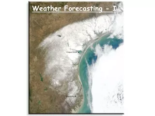
When I originally picked my 48-hour forecast, the midlatitude cyclone was in South Carolina. 48 hours later, the midlatitude cyclone was starting to move into the Atlantic Ocean. According to the satellite image dated October 18th, there showed a great amount of gray shadow all across the Atlantic and South Carolina. The Doppler radar dated October 18th, showed a positive shift in South Carolina region closer to the Atlantic Ocean. Regarding ridges and troughs, there is a small trough that barely passes through South Dakota on the top of the state. There is a ridge that flows through the top and bottom of the state. Based on all these observations, a midlatitude cyclone has occurred in the South Carolina area.
ADDS Info • METAR test- KGGE 181555Z AUTO 00000KT 10SM SCT010 BKN070 24/22 A3000 RMK AO2 • Conditions at- KGGE (Georgetown,SC, US) observed 1555 UTC October 18 2013
ADDS info continued… • Tempature- 24.0 C (75 F) • Dewpoint- 22.0 C (72 F) RH= 89% • Pressure- 30.00 Inches Hg (1016.0 mb) • Winds- Calm • Visibility- 10 or more miles (16+ km) • Ceiling- 7000 feet AGL
ADDS info continued… • Clouds- Scattered clouds at 1000 feet AGL, broken clouds at 7000 feet AGL, broken clouds at 10000 feet AGL • Weather- Automated observation with no human argumentation; there may or may not be significant weather present at this time
Reflection • . It is really interesting that all these tools are available for anyone to use. I was fascinated on looking at the different tools used to find the midlatitude cyclone. I never knew that this information is available for anyone to use. As a student I learn best through visual and hands on. It really made me understand much better because I was able to explore and put the pieces together.
Reflection • It is really interesting that all these tools are available for anyone to use. I was fascinated on looking at the different tools used to find the midlatitude cyclone. I never knew that this information is available for anyone to use. As a student I learn best through visual and hands on. It really made me understand much better because I was able to explore and put the pieces together.