Download

1 / 18
180 likes | 219 Vues
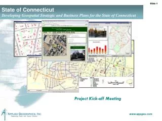
Join us for the Project Kick-off Meeting to develop Geospatial Strategic and Business Plans for Connecticut. Our approach includes in-depth interviews, information gathering sessions, and visioning exercises to establish goals. The Strategic Planning phase focuses on refining our approach, identifying key stakeholders, and setting goals at all government levels. The Business Planning phase involves creating a detailed plan for the identified initiative, including goals, benefits, requirements, budget, and implementation steps. Follow our progress in aligning with federal initiatives and the NSDI 50 States Initiative. Learn about successful statewide GIS programs and the criteria for their effectiveness. Join us to shape the future of geospatial planning in Connecticut!

E N D
State of ConnecticutDeveloping Geospatial Strategic and Business Plans for the State of Connecticut Project Kick-off Meeting
Agenda • Project Approach • Strategic Planning • Business Planning • Info Gathering Session Details • In-depth Interview Candidates • Nine Criteria for a Successful Statewide GIS Program • Establishing the Vision and Goals for this Project
Project Approach and OverviewStrategic Planning… • Kickoff Meeting • Refine approach to Connecticut specifics • Five In-depth Interviews • Could be with key stakeholders not included in HLSGIS • Could be with stakeholders that were involved, drill into further details • Three Information Gathering Sessions • Three Group Visioning sessions • Goal identification or clarification • Define needs at all levels of government • Geospatial Council Mtgs • Report and Track progress • Gauge degree of consensus • Make final decisions and adopt • Authoring Plan • Use NSGIC’s prescribed format • Answer sub-set of questions raised in the templates • Accurately articulate the vision for expanded statewide GIS in CT
Project ApproachBusiness Planning… • Steering Committee • Identify the single initiative that will be detailed in the first Business Plan • CT may ultimately have several Business Plans, one for each key initiative • Identify Program Goals • And congruence with overall Strategic Plan • Identify Program Benefits • Structure like a business case • Economic benefits? • Value-added benefits? • Avoided costs/problems? • Why should a political leader, Commissioner, or Executive champion this effort? • Detail Program Requirements and Budget • Deliverables • Technologies/Methodologies employed • Document oversight and organizational approach • Develop Implementation Plan • Steps and phasing necessary to achieve goals
Federal Initiatives • National Spatial Data Infrastructure (NSDI) • Compilation and integration of data for 7 framework layers • Geodetic Control • Cadastral (parcels) • Political Boundaries • Hydrography • Imagery (orthos) • Elevation (orthos) • Transportation (Air, Roads, Inland Waterways, Rail, Transit) Critical Infrastructureis not on FGDC list – why? • Geospatial One-Stop / National Map • Portals for access to nationwide data • Really just a pointer to the best source (local) • Homeland Security Infrastructure Program (HSIP) • Effort to collect a core set of data for use in time of an emergency
Bolton CRCOG Hartford NSDI and Statewide Spatial Data Infrastructures NSDI 50 States Initiative • Data sharing between levels of government • The best data are local • Local rolls up to regional/state • States roll up to National SSDI Connecticut SSDI CA SSDI MA
The process matters! “Plans are nothing; planning is everything” Dwight D. Eisenhower “Plans are of little importance, but planning is essential” Winston Churchill http://www.whitehouse.gov/history/presidents/de34.html http://en.wikipedia.org/wiki/Image:Winston_Churchill.jpg
50 States Initiative9 criteria of a successful statewide GIS program • A full-time,paid coordinator position is designated and has the authority to implement the state’s business and strategic plans • A clearly definedauthority exists for statewide coordination of geospatial information technologies and data production • The statewide coordination office has a formal relationship with the state’s Chief Information Officer (CIO) • A champion (politician, or executive decision-maker) is aware and involved in the process of geospatial coordination • Responsibilities for developing the National Spatial Data Infrastructure and a State Clearinghouse are assigned • The ability exists to work and coordinate with local governments, academia, and the private sector • Sustainablefunding sources exist to meet project needs • GIS Coordinators have the authority to enter into contracts and become capable of receiving and expending funds. • The Federal government works through the statewide coordinating authority
How do we rate? How do we rate?
How do we rate? How do we rate? • Final Tally: • Meets criterion: 5 • Partially meets criterion: 1 • Does NOT meet criterion: 3
What are some things other states have tried to achieve?That is, their programmatic goals under the overarching Vision • Development of statewide data layers • Structured program for regularly updated orthos • Completion of USGS “framework layers” • GIS Governance Evolution • Creation of a Geographic Information Officer (GIO) title (and office) within the State • Development of Geospatial Data/Metadata Portals • E.g., Geospatial One Stop (and state level “GOS’s”) • Development of web services infrastructure • To facilitate data distribution and sharing • Do any of these things resonate with CT? • What else?
What is the Primary Goal of the Strategic Plan for Connecticut? • To become/remain eligible for Federal funding? • Having the plan allows CT to “check that box” • To create a Statewide Spatial Data Infrastructure (SSDI)? • Good municipal data will help drive smarter state level planning and decision making • This is a NSGIC/FGDC priority, and behind the CAP grant • To participate in NSDI? • Providing good state level data to the federal government should help Connecticut • In times of crisis do federal planners/responders have access to the best data? Is this already being done as part of HLSGIS? • Are resources being equitably distributed/deployed to CT? • To generally “advance” GIS in the state? • Raise general awareness? • Enlist a high-level Champion?
Questions & Discussion In 2005 the CT Geospatial Information Systems (GIS) Council was created to coordinate, …a GIS capacity for the state, regional planning agencies, municipalities, and others as needed. The system must guide and assist state and local officials involved in transportation; economic development; land use planning; environmental, cultural, and natural resource management; public service delivery; and other areas as necessary Who are we? Who else should we consider as being a stakeholder?
Questions & Discussion What does statewide mean to us? (e.g., what is our user base, and what are their needs?) What are our strengths? (e.g., experienced staff, funding, authority, political support, communications infrastructure for collaboration, technical skills, marketing skills, etc.) What are our weaknesses? (e.g., lack of staff, lack of funding, lack of expertise, and lack of any of the other things listed under strengths; also, wildly divergent needs, disagreement on goals and priorities, etc.)
Questions & Discussion What are the roadblocks and political barriers? (e.g., election year, political party in control, support or lack of support for political issues such as economic development, open space preservation, and system of taxation.) What are the key success factors for us? (e.g., coordination of efforts, improvement of base mapping, meeting mandates, improved efficiency, return on investment) What are the predominant pitfalls for us? (e.g., lack of funding, limited resources, lack of available time)