Download

1 / 16
160 likes | 257 Vues
This progress report outlines efforts to maintain clean water systems in the San Marcos River watershed amidst rapid growth and increased impervious cover. The project utilizes geospatial technology and data analysis to study the impact of development on the watershed and aims to prevent harm to native species and human water uses. The report details the data acquisition process, BASINS training, LULC mapping, and future plans for applying the obtained information to ensure acceptable water standards. The final deliverables include an interactive website, detailed report, poster, and data files. The conclusion highlights the successful acquisition of data and the importance of collaboration and determination in achieving conservation goals.

E N D
Basin Conservation: The Environmental Health of the San Marcos Watershed Progress Report BaCon Makes Everything Better!
Contents Background Purpose Scope Schedule Timeline Data LULC Maps BASINS Data Analysis Final Deliverables Conclusion
Background • Rapid growth of San Marcos • Increase in construction, impervious cover • More runoff • Less infiltration • Non-point Source pollution • Concern for Health of the Upper San Marcos River Watershed • Goal is to maintain clean, clear water and prevent harm to native species and the human water uses.
Purpose • Assist in promoting an intelligent growth design for San Marcos while maintaining the pristine environment of the aquatic systems. • Use collected Data, Research Material, and Geospatial Technology • Study the impact of increased impervious cover in the Upper San Marcos River Watershed • End result will provide interactive maps via a website
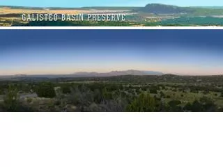
Scope • All of the Upper San Marcos River Watershed going into the San Marcos River • Spring Lake • Until its confluence with the Blanco river • Western city development through the year 2035
Schedule • Data Acquisition went well. • Due to a slight issue during the BASINS training we have to extend the amount of time allotted for it. • Data Analysis should not take any longer however, so the date we should be done with it is the same. • The time set aside for web site development, final presentation, and other final deliverables should also remain the same.
Timeline • Calendars Include: • Data Acquisition (Orange) • BASINS training (Yellow) • Data Analysis (Light Green) • Web design and preparing the final presentation (Dark Green) • Final Editing (Blue)
Data • Acquisition successfully completed • Most downloaded directly through BASINS • National Hydrography Dataset plus (NHDplus) from Meadows Center • Water quality guidelines from Texas Commission on Environmental Quality (TCEQ) • Spatial data from Texas General Land Office and Texas State University • Land Use Data for City of San Marcos from the Meadows Center • Research finished on the species of interest
LULC Maps • The land use and land cover data will be at the core of our project. • We decided to showcase the present and predicted LULC percentages in San Marcos in a couple of maps.
BASINS • Training • Using a modeling Program • Working with HSPF • National Hydrography Dataset Plus • Issues • Resolution
Data Analysis • Future Plans: • Apply information to ensure acceptable water standards • Want clean clear water • Use endangered species research • Will run all obtained data through BASINS HSPF model several times to obtain results. • Will compare of current to potential impervious cover for San Marcos 2035 • Will assess the of environmental impact
Final Deliverables • Future Plans: • Website with Interactive Capabilities • Dreamweaver • Detailed Final Report • Poster • CD with the above listed Data, Instruction File, andReadme File • Hard Copies of SignificantMaps
Conclusion • Mostly on Schedule, made slight extension for BASINS training • All data has been acquired as planned • Changes in endangered species • Future work through Basins, Arc Map, and data analysis • Success through hard work, communication, determination, and cooperation