Download

1 / 23
230 likes | 297 Vues
Detailed analysis of representing Evapotranspiration in ESPAM2.0, its adjustment factors, and improvements proposed for ESPAM2.X using METRIC technology.

E N D
Review of ET Representation in ESPAM2.0 and How to Represent ET in ESPAM2.X Presented by Mike McVay September 12, 2012
How we represent ET in ESPAM2.0 ET = [(ADJspr)(Area)(1-REDspr)(SPR) + (ADJgrav)(Area)(1-REDgrav)(1-SPR)]*ETtrad where: ET = evapotranspiration volume on an individual irrigated parcel ADJsp r = ET adjustment factor for sprinklers Area = area of parcel REDspr = reduction for non-irrigated inclusions, sprinklers SPR = sprinkler fraction for entity ADJgrav = ET adjustment factor for sprinklers REDgrav = reduction for non-irrigated inclusions, gravity ETtrad = depth of ET on irrigated lands calculated by traditional methods ADJspr and ADJgrav include a global adjustment for high ET adjacent to irrigated lands For the specifics of ET calculation refer to ESPAM 2 Design Document DDM-V2-11
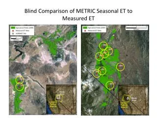
General Process for Calculating ET in ESPAM2.0 Calculate Traditional ET for Irrigated Lands using county crop mix data and ETIdahovalues for Etact(calculated with crop coefficient and reference ET). Calculate “Actual ET” on Irrigated Lands using METRIC (pseudo-average 2000 and 2006). Calculate a preliminary adjustment factor for each entity using METRIC/Traditional ET. Calculated a global adjustment coefficient on a buffer area adjacent to Irrigated Lands. Use the global coefficient to “correct” the preliminary adjustment and obtain the final ET adjustment factor for each entity (ADJsp r and ADJgrav). Calculate ET volume for each entity. ET = [(ADJspr)(Area)(1-REDspr)(SPR) + (ADJgrav)(Area)(1-REDgrav)(1-SPR)]*ETtrad
Preliminary ET Adjustment Factors • The preliminary by-entity adjustment factors compensate for the following potential differences between METRIC ET and Traditional ET: • Differences in crop vigor due to chronic water stress, poor soil, insects, or disease. • Imprecision in underlying data. • Entity has higher/lower-consumptive crops than the county average. • Entity experiences higher/lower ET than at county weather station. • Low-intensity management. • Imprecision in traditional calculations and coefficients. • Changes in conditions from when traditional coefficients were developed • More frequent irrigation. • More dense planting. • Increased vegetative yield. • Longer growing season.
Global ET Adjustment Coefficients • The global adjustment coefficient compensates for the following potential differences: • Imprecision in underlying data. • GIS and RED overstate/understate irrigated area. • Effects on or from non-irrigated lands adjacent to irrigated lands. • Advection of heat into irrigated land. • Overspray and runoff.
Issues or Concerns with ESPAM2.0 Methods • Acute water shortage in years other than 2000 and 2006 cannot be compensated for. • Acute water shortage in 2000 or 2006 that is not a chronic condition cannot be compensated for. • Calculating ET based on Irrigated Lands Maps (used RED factors to mitigate). • Different data sources and methods for generating maps may not be comparable. • Non-irrigated inclusions in the maps may not be accounted for properly. • Traditional ET calculation method imprecision (used adjustment factors, ad-hoc corrections). • County crop mix data quality is a concern. • County weather stations may not be representative of the entities. • Non-irrigated lands adjacent to the irrigated lands. • Other consumptive use like small domestic, dairies, wetlands and industrial. • The calculation is complex which introduces compounding uncertainties.
Moving Forward to ESPAM2.X – METRIC We want to use METRIC directly in the model. Allows use of the best available data in the correct spatial and temporal context. Removes the need for adjustment factors. Removes the need for RED factors in ET calculation. Eliminates reliance on county crop mix. Uses more spatially appropriate weather station data. Uses high-definition spatial definition of LANDSAT. Captures edge effects outside of Irrigated Lands Maps (if using a buffer). ….but not all years in the model period will have METRIC coverage. Next Step – Prioritize METRIC processing.
Potential METRIC Processing ESPA 1984 - too sparse 1985 - too sparse 1986- yes (METRIC in Progress)1987 - not as populated as 1986, but possible for METRIC 1988 - no April-May for METRIC on path 40 1989 - no Sept-Oct for METRIC on path 40, poor on path 39 1990 - possible METRIC on 40, not on 39 1991 - no 1992 - possible METRIC for 40 and 39 1993 - possible for METRIC, no April-May on 39 1994 - no May-June for METRIC path 40 1995 - no 1996 - yes (METRIC DONE) 1997 - yes, iffy METRIC for June-July on 39 1998 - no May for METRIC on 40 and 39 1999 - no for METRIC in spring2000 - yes (METRIC DONE) 2001 - yes for METRIC on both paths 2002 - yes (METRIC DONE)2003 - iffy for METRIC for both paths (path 40 DONE through August (no images after that)) 2004- yes for METRIC on both paths 2005 - iffy for METRIC 2006 - yes (METRIC DONE)2007-possible, but challenging for METRIC on path 40 2008 - yes (METRIC DONE) 2009 - yes (METRIC in Progress) 2010 - yes (METRIC in Progress) 2011 - yes for METRIC on both paths 2012 - If coverage is available, do we want this year – dry summer (SMOKE?)
Non-METRIC ET Years 1984 - too sparse 1985 - too sparse 1987 - not as populated as 1986, but possible for METRIC 1988 - no April-May for METRIC on path 40 1989 - no Sept-Oct for METRIC on path 40, poor on path 39 1990 - possible METRIC on 40, not on 39 1991 - no 1993 - possible for METRIC, no April-May on 39 1994 - no May-June for METRIC path 40 1995 - no 1997 - yes, iffy METRIC for June-July on 39 1998 - no May for METRIC on 40 and 39 1999 - no for METRIC in spring2001 - yes for METRIC on both paths 2003 - iffy for METRIC for both paths (path 40 DONE through August (no images after that)) 2004- yes for METRIC on both paths 2005 - iffy for METRIC 2007-possible, but challenging for METRIC on path 40 2011 - yes for METRIC on both paths 2012 - If coverage is available, do we want this year – dry summer (SMOKE?)
Non-METRIC ET Years 1980 – 1983 weather data? 1984 - too sparse 1985 - too sparse 1987 - not as populated as 1986, but possible for METRIC 1988 - no April-May for METRIC on path 40 1989 - no Sept-Oct for METRIC on path 40, poor on path 39 1990 - possible METRIC on 40, not on 39 1991 - no 1992 - possible METRIC for 40 and 39 1993 - possible for METRIC, no April-May on 39 1994 - no May-June for METRIC path 40 1995 - no 1997 - yes, iffy METRIC for June-July on 39 1998 - no May for METRIC on 40 and 39 1999 - no for METRIC in spring2001 - yes for METRIC on both paths 2003 - iffy for METRIC for both paths (path 40 DONE through August (no images after that)) 2004- yes for METRIC on both paths 2005 - iffy for METRIC 2007-possible, but challenging for METRIC on path 40 2011 - yes for METRIC on both paths 2012 - If coverage is available, do we want this year – dry summer (SMOKE?) 25 Years need a non-METRIC method of determining ET (temporary and permanent)
Moving Forward to ESPAM2.X – ET Needs • What we NEED for the non-METRIC years • Need a method for 1980-1985 when METRIC is not available. • Need to Interpolate or extrapolate METRIC to non-METRIC years, or • Need to independently calculate or estimate ET for non-METRIC years. • What are the OPTIONS for the non-METRIC years? • Interpolate or Extrapolate METRIC data to non-METRIC years. • Find correlation to some index (like NDVI). • Mathematical interpolation (like a linear interpolation or average of METRIC). • Similar-year substitution. • Independent calculation or estimation method. • NDVI Method or other simplified proxy. • Satellite-based method (MODIS, SEBAL). • Traditional calculation methods.
Options for Representing ET in ESPAM2.X Presented by Mike McVay September 12, 2012
Brainstorming Options This is not a presentation on the various options, how they work, or the benefits and drawbacks. This is a list intended to generate ideas and discussion.
Satellite-based Options • Surface Energy Balance Algorithm for Land (SEBAL). • Maybe an alternative for early 1980’s due to less ground data requirements. • Not sure of satellite coverage in 1980’s. • Simplified Surface Energy Balance (SSEB). • METRIC Flat Model. Use as a filler until METRIC Mountain Model products are ready. • Apply METRIC to MODIS imagery. • Lower resolution (1 km), but may be able to correlate with METRIC years. • Daily images, may help with cloudiness. • Satellite begins year 2000. • Advanced Very-High Resolution Radiometer (AVHRR). • Lower resolution (1 km), but may be able to correlate with METRIC years. • 14 Images per day • Satellite begins year 1994. • Advanced Spaceborne Thermal Emission and Reflection Radiometer (ASTER ). • Cost is $50 per image. • Daily images. • Satellite begins year 1999. • Other satellites?
Other Options • ESPAM2.0 Method • Different application of the Kc * ETr method. • METRIC-driven adjustment factors. • NDVI Method or other simplified proxy. • Interpolate or Extrapolate METRIC data to non-METRIC years. • Find correlation to some index (like NDVI). • Mathematical interpolation (like a linear interpolation or average of METRIC). • Similar-year substitution.
Other Considerations • Winter (non-irrigation season) ET. • ET on non-irrigated land. • Method consistency vs. best estimate. • Use of partial MERTIC in years with incomplete imagery. • PEST adjustment of ET. • PEST Adjustment of non-METRIC ET? • PEST adjustment of METRIC ET? • Alternate crop-mix data source.