Advanced Geocoding
Advanced Geocoding. Advanced Geocoding. Most of advanced geocoding work involves prepping the street and student file BEFOREHAND . Steps to improving matched records: Fix obvious problems first Standardize student and street file using the same address locator style.

Advanced Geocoding
E N D
Presentation Transcript
Advanced Geocoding • Most of advanced geocoding work involves prepping the street and student file BEFOREHAND. Steps to improving matched records: • Fix obvious problems first • Standardize student and street file using the same address locator style. • Download and use the address locator for PARSED addresses.
Advanced Geocoding Fix Obvious Problems First • Use Excel or your student records system to fix student addresses before geocoding • Fix spelling errors • Change Apt 210 to #210 • Spell out abbreviations in student table similar to street dataset (i.e MLK to Martin Luther King, Jr.) Digitize new streets and add address ranges.
Advanced Geocoding Standardize Student File: • Convert student file to a table in a GDB • Use ArcToolBox to Standardize Addresses
Advanced Geocoding • StandardizeStudentFile: • Create new output file with parsed address fields. Now You Try! Standardizing the Student File
Advanced Geocoding Standardize Street File: • Streets must be a feature class inside a GDB. • Use ArcToolBox to Standardize Addresses
Advanced Geocoding Standardize Street File: • Choose US Streets Locator style • Do NOT output a HouseNum field. (Used to correctly parse street name only.)
Advanced Geocoding • Resulting Street Fields: • New fields are indicated by the header prefix ADDR_. Now You Try: Standardizing the Street File
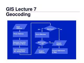
Advanced Geocoding • Now, you can begin geocoding.... • In ArcCatalog, create a new address locator. Choose the US Streets Parsed Address (DDP) file
Advanced Geocoding • Browse for your parsed street file. Now You Try: Create An Address Locator
Advanced Geocoding • Once In ArcMap... • Begin a geocoding session as normal. Notice the address input fields can handle parsed information in the student table. Now You Try: Geocode Addresses
Advanced Geocoding • Fixing Unmatched Students: • Select unmatched and summarize by street name. • Add “OD” field and mark out-of-district students. • Rebuild street index if you make edits: • Find more information in the Geocoding User Guide This will update your address locator and allow you to geocode using the latest edits. A new file will appear in your GDB (i.e. GC_SS7). Do not delete – this file contains the street index needed to complete geocoding.
Advanced Geocoding Fixing Errors In the Beginning Geocoding class, you learned how to fix student record errors. Here you will learn how to fix: • Duplicate street address ranges • Non-existent street addresses and • When to re-build the address locator Now You Try: Fix Street Errors