Geocoding Addresses
Geocoding Addresses. A Special Topic Presentation by Karen Harner March 20, 2003. What is geocoding?. Geocoding is defined as the process of creating geometric representations for descriptions of locations

Geocoding Addresses
E N D
Presentation Transcript
Geocoding Addresses A Special Topic Presentation by Karen Harner March 20, 2003
What is geocoding? • Geocoding is defined as the process of creating geometric representations for descriptions of locations • In the case of address geocoding, one generally uses points to represent desired addresses
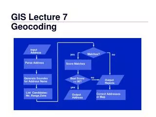
The process of geocoding: • Standardizing the address • Searching for potential candidates • Scoring each candidate • Matching address to best candidate
Standardizing the address • During this step the address is broken into components • For example: street number, street name, street type and street direction
Searching for potential candidates • The geocoding service searches the reference data to find a feature with address components similar to your standardized address • Uses spelling sensitivity settings
Scoring each candidate • The geocoding service assigns a value from 0 to 100 for each potential candidate • Each address component is considered in the scoring • The score will be lower if components are misspelled, incorrect or missing
Matching address to best candidate • The geocoding service looks for the potential candidate with the highest score • If the score exceeds the minimum match score setting, then the service matches the address with that candidate
Geocoding Service Settings • Spelling Sensitivity • Minimum Candidate Score • Minimum Match Score
Rematching • If unhappy with initial results, one can modify settings and geocode the table of addresses again • Also, you can interactively rematch addresses
An example • Using geocoding to produce points representing the addresses of various entertainment centers in Charlottesville
The process • Choose Geocode Addresses under the Tools menu • Add a Geocoding Service using the Tiger road file • Browse to the desired table and click ok
The process cont’d… • Since 5 unmatched, go back and match interactively
The process cont’d… • Able to rematch 2 points • Still 3 unmatched for various reasons
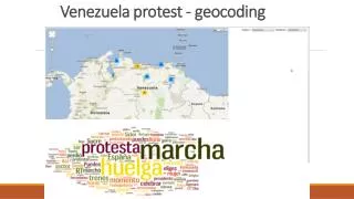
Uses of geocoding include: • Matching UFO sightings to zip code polygons • Combating Crime by finding areas of increased criminal activity • Mapping polling locations and analyzing neighborhood voting trends • Plotting sightings of endangered species and correlating to suitable habitat and legally protected areas • Farmers are mapping their fields' health and applying fertilizers and pesticides according to need
Sources • Using ArcMap : GIS by ESRI / Michael Minami.
Internet Resources • http://libraries.mit.edu/gis/teach/geocoding.html • http://artsandscience.concordia.ca/geog/arcgis/Geocoding_tutorial.pdf • http://gislounge.com/features/aa053100a.shtml
Internet Resources Cont’d • http://www.cadenceweb.com:8080/features/casestudies/ppdgis.html • http://www.mitchellgeo.com/NEW_SITE/Pages_Site/geocorner.htm