RIVERS!!!!!!!! (and valleys)
RIVERS!!!!!!!! (and valleys). Chapter 12 (page 39). Because Bill Nye always makes things better…. http ://www.youtube.com/watch?v=Xtk_bqkfeyE. Drainage Basins, Streams, Rivers.

RIVERS!!!!!!!! (and valleys)
E N D
Presentation Transcript
RIVERS!!!!!!!!(and valleys) Chapter 12 (page 39)
Because Bill Nye always makes things better… http://www.youtube.com/watch?v=Xtk_bqkfeyE
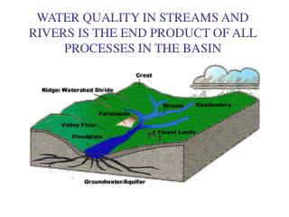
Drainage Basins, Streams, Rivers Adrainage basin(watershed, catchment) is a piece of land where water (rain and melting ice) drains into a larger body of water. Includes the streams, rivers and channels OPEN SYSTEM separated by divides When water accumulates upland, and flows along a definite course, they are called streams Small streams tributary streams Tributary streams flow down and join together to connect to a river
Types of drainage patterns The hardness of the rock layers in the region determines the formation of certain drainage pattern that results There are three types of drainage patterns
Drainage pattern #1: Dendritic Mostcommon pattern Resembles vein or tree branch pattern Forms on flat surfaces where the rock layers are of uniform hardness Form in v-shaped valleys where many small tributaries join together and then join onto a main river, giving it the appearance of a tree
Drainage pattern #2: Trellis As a river flows down a valley, smaller tributaries flow into it from steep mountain slopes Tributaries enter the main river at approximately 90 degree angles, causing a trellis-like appearance of the drainage system Trellis drainage is characteristic of areas with alternating parallel valleys and ridges, and folded mountains
Drainage pattern #3: Radial The streams radiate equally outwards from a central high point Volcanoes (as well as domes and laccoliths Cone-shaped mountains) usually display excellent radial drainage
River Valley shapes Dry (arid) regions steep slope forms canyons (vertical erosion) Wet regions gentle slope heavy sediments in water (vertical erosion)
Four stages of a River development Youth stage Mature stage Old age stage Rejuvenated stage http://www.youtube.com/watch?v=AjZLAw_lgZ4&feature=related
Stage #1: Youth Stage River cuts a deep V-shaped valley (steep gradient) Flows in highlands of mountainous areas with very little shifting of its channel Usually small in size Dominated by erosion fast, violent water little deposition Little floodplain, but rapids, waterfalls, and boulders may be found
Stage #2: Mature Stage Receives the waters of many tributaries River increases in size and slows in velocity more deposition Eroded the bed downward and gotten closer to the base level Though it is still eroding downwards,it mainly erodes laterally to form meandersand eventuallyflood plains
Stage #3: Old Age stage Extensive meandering forms oxbow lakes Its gradient and speed are very slow, Because of this it has lost the power to erode downwards and carry as much sediment load deposits rich alluvium on the floodplain http://www.igeography.ie/mature-stage.html
Stage #4: Rejuvenated stage River returns to the youthful stage Vertical erosion creates v-shaped valley and process starts again
The four stages http://www.slideshare.net/Dannyoc/stages-of-a-river
Erosional action of rivers (4 types) THIS SHOULD BE FAMILIAR!!! Hydraulic action Abrasion Attrition Corrosion
Ways that rivers transport sediments THIS SHOULD BE FAMILIAR!!! Solution Suspension Saltation Traction http://library.thinkquest.org/28022/transport/index.html
Landforms associated with upland rivers Steep gradient (steep slope) Water flows swiftly with vertical erosion Waterfalls occur where rocks have eroded quickly Igneous rock wears out much slower than others (e.g. sedimentary rock)
Potholes, Gorges and Canyons Potholes develop along river beds Pebbles get trapped Water spins and abrasion deepens the hole Eventually a gorge or even a canyon may result (narrow slot in landscape)
Landforms associated with lowland rivers When the river has reached an elevation close to the sea level, a flood plain may result Lateral erosion and energy River can flow overflow and deposit rich alluvium(ideal for farming)
Meanders, undercut banks and slip-off slopes Erosion is greatest and fastest along the outer edge of a meander (bend) Undercut bank (outer edge) Point bar/ slip-off slope (inner bank)
Levees and dikes • Levees: mounds of sediment that slowly build up along the river bank • Hold in flood water • Natural dikes • Common in valleys where river cannot carry all of its load • Dikes: artificial levees created to minimize flooding
River terraces • Lowland regions sometimes uplift and the meandering river begins vertical erosion again • Once uplifting stops and a flood plain is formed, lateral erosion is once again dominant • The old, uplift flood plain sits high above river banks • These ledges are called river terraces • Let’s draw it out!!!
Braided river channels Sand and gravel “islands” may break up the water flow, so rivers take on a braided appearance Transport large volumes of debris when deposited, creates sand bars and islands
River deltas • A river carries sediment from its drainage basin into the ocean • Current carries them into the ocean before they are deposited • Sand (heavy) silt clay (light) • Large rivers have broad deltas with shallow water extending far into the sea • Very gentle slope • Waves cannot erode as effectively
3 main types of delta Arcuate delta Bird’s foot delta Estuarine delta LOOK ON PAGE 190 OF BLUE GEOGRAPHY BOOK FOR AWESOME ILLUSTRATIONS FO DELTAS AROUND THE WORLD!!!
Arcuate delta Carries water and sediment across a symmetrical delta in distributaries Inverted cone shape EX. Nile River Delta
Bird’s foot delta Many distributary channels branch out from main river channel Bird’s foot shape EX. Mississippi River Delta
Estuarine delta Forms when river sediment is deposited in a submerged river mouth Estuary shape