Trigonometry and the Global Positioning System
50 likes | 198 Vues
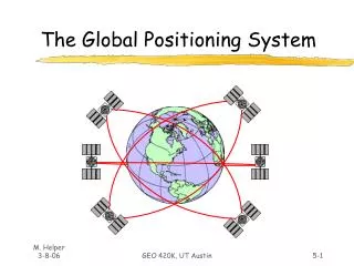
The Global Positioning System (GPS) relies on 24 satellites orbiting Earth to provide accurate location data. By utilizing the positions of satellites P, Q, and R, which are not aligned linearly, we can determine the position of a point S in three-dimensional space. If we know the distances from S to these satellites, trigonometry enables us to calculate S's precise location, whether it represents a person walking across Dartmoor or a military aircraft in the sky. Understanding trigonometric principles is crucial for GPS functionality.

Trigonometry and the Global Positioning System
E N D
Presentation Transcript
GPS consist in 24 satellites that are orbiting around the earth in very precise orbits.
We have three points P, Q and R, not in a straight line. We know their positions in three dimensions. If we know the distance of another point S from P, Q and R we can use trigonometry to fix the position of S in three dimensions. • In a Global Positioning System P, Q and R are GPS satellites travelling though space at about 15 000 km/hour about 20 000 km above the Earth, and S could be a man walking across Dartmoor, or it could be a military aircraft flying