Download
1 / 16
170 likes | 297 Vues
Explore methods for polygon operations, areal interpolation, and geometric measurements in spatial analysis. Learn about polygon overlay, buffer creation, and data transformations. Dive into conflation and data integration concepts in GIS.

E N D
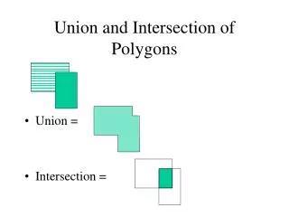
Union and Intersection of Polygons • Union = • Intersection =
Areal interpolation • How to compute new values for polygons formed of preexisting ones • Simple when polygons are nested A B What is “total” population of the solid box? C D
Areal interpolation • More difficult when new units are not nest-able • typical example 1980 census units compared to 1990 - • because of population growth the 1990 units are smaller than the 1980 units and overlap boundaries 1980 blocks 1990 blocks
Methods to interpolate • Use proportionate areas • e.g. convert total population to population density • compute area for new units and reallocate • use centroids of (a large number) of locations as x, y and z - interpolate z and reallocate into new polygons • use other factors to model interpolation • e.g. consider land use for area and distribute original population differentially in unit before re-allocation 1980 blocks 1990 blocks
Measurement of shapes of polygons • In addition to attributes and areas of polygons measures reflecting shapes may also be important • examples • congressional districts • package delivery, newspaper zones • A variety of possible measures • measures of compactness (area to perimeter measures) etc.
Polygon clipping • Creation or retrieval o polygons “included” in a second polygon • examples • Parcels in city limits • soils in river floodplain
Buffering • General process • creation of new entities defined by boundaries (inside or outside or both) of existing entities offset by a particular distance and parallel to the original boundary
Buffering continued • Ways in which multiple ‘starting entities are considered is important • ways in which buffer zones are viewed “Donut” entities Two entities Multiple discs that overlap in space One entity
More on buffering • Other issues • termination of buffer entities Multiple entities can lead to very complex polygon structures
Polygon overlay • probably the most challenging computational problem in spatial systems • general process • identify line segments involved - preferably having topology • establish minimum enclosing rectangle • determine if line segments in one polygon are inside the other by a point-in-polygon • find intersections of segments that represent boundaries • create records for new line segments and associated topology • re-label all polygons
Examples Draw boxes around polygons boxes don’t overlap polygons don’t Boxes overlap - 1. check for point in polygon node/vertex of B is in A 2. Identify intersections 3. Create new nodes A B
Problems with polygon overlay • non-coincidence of lines • slivers • line coincidence
Pre-post topology and polygon overlay • different systems deal with topology (and latter polygon overlay) differently • topology as part of data development • most GIS systems Arc, GRASS etc. • topology built as analysis needed • MGE • No clipping/overlay • ArcView 3.0 now in 3.1 • GeoMedia 2.0 but in Geomedia 2.0 • strengths and weaknesses
Data transformations • changes in dimensionality • ex. Polygon to line to point as scale changes • changes in position • ex; map projections, • scaling, • rotation, • rubber sheeting • affine • projective (as in some map projection) • topological
Conflation • “merging” of two data sources often from two scales or level of detail • ex: detailed transportation map and street names from TIGER North Street 300 200 100 Easy Street