Detailed Landing Zone (LZ) Information for Various Locations
This document provides comprehensive data for multiple landing zones (LZs) including coordinates, elevation, wind conditions, and egress information. It outlines specific details about each LZ, such as land type (grass or asphalt), the presence of trees and power lines, as well as noise abatement regulations. Each location is classified as unclassified, emphasizing the need for careful planning regarding flight operations. The document also includes primary and alternate patterns for approach, alongside lunar data illumination angles.

Detailed Landing Zone (LZ) Information for Various Locations
E N D
Presentation Transcript
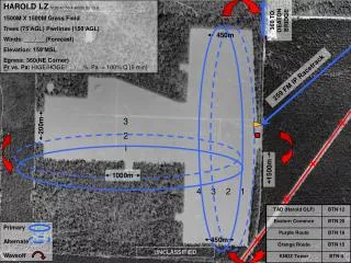
HAROLD LZ N 30 40 50.4 W086 53 13.8 1500M X 1500M Grass Field Trees (75’AGL) Pwrlines (150’AGL) Winds: ___/___(Forecast) Elevation: 159’MSL Egress: 360(NE Corner) Pr vs. Pa: HIGE/HOGE: __/__%, Pa = 100% Q (5 min) 360 TO DEATON BRIDGE 450m 259 FM IP Racetrack 3 200m 2 1 1500m 1000m 4 3 2 1 Primary Alternate Waveoff 450m UNCLASSIFIED
Site 8 LZ N 30 32.57 W087 22.07 1700yd X 1700yd level grass field Trees (75’agl), Fuel Pits (NE Corner) Winds: ___/___ (Forecast) Elevation: 159’MSL Egress: 060 (SE Corner) Pr vs. Pa: HIGE/HOGE: __/__% Pa = 100% (5 min) UNCLASSIFIED 1700yd NOFLY West of Beuhlah Rd Navy Federal Noise Abatement: NO FLY below 500 AGL Primary Alternate 1680yd
FLORALA (0J4) LZ N 31 02 32.5 W 086 18 42.05 3197’ X 75’ Asphalt Runway (22/04) Trees (75’AGL) SE / Power lines (50’AGL) NE Winds: ___/___(Forecast) Elevation: 314’MSL Egress: Pr vs. Pa: HIGE/HOGE: __/__%, Pa = 100% Q (5 min) N 22 3197’ X 75’ Primary Pattern: Alternate Pattern: Lunar Data Illumination: Angle: Azimuth: 04 UNCLASSIFIED
DEFUNIAK SPRINGS (54J) LZ N 30 43 55.79 W 086 09 11.61 4146’ X 60’ Asphalt Runway (27/09) Trees (75’AGL) SE/SW Winds: ___/___(Forecast) Elevation: 289’MSL Egress: Pr vs. Pa: HIGE/HOGE: __/__%, Pa = 100% Q (5 min) N 09 27 4146’ X 60’ P P Primary Pattern: Alternate Pattern: Lunar Data Illumination: Angle: Azimuth: UNCLASSIFIED
ATMORE (01R) LZ NN 31 01 03.41 W 087 26 48.05 4952’ X 80’ Asphalt Runway (36/18) Power lines (50’AGL) NE Winds: ___/___(Forecast) Elevation: 287’MSL Egress: Pr vs. Pa: HIGE/HOGE: __/__%, Pa = 100% Q (5 min) N 18 4952’ X 80’ Primary Pattern: Alternate Pattern: P P Lunar Data Illumination: Angle: Azimuth: 36 UNCLASSIFIED
BAY MINETTE (1R8) LZ N 30 52 11.73 W 087 49 11.7 5500’ X 79’ Asphalt Runway (26/08) Trees (75’AGL) Winds: ___/___(Forecast) Elevation: 248’MSL Egress: Pr vs. Pa: HIGE/HOGE: __/__%, Pa = 100% Q (5 min) N 26 Primary Pattern: Alternate Pattern: 08 5500’ X 79’ P P Lunar Data Illumination: Angle: Azimuth: UNCLASSIFIED
FOLEY (5R4) LZ N 30 25 39.6 W 087 42 03.5 3700’ X 74’ Asphalt Runway (36/18) Trees (75’AGL) East of LZ Winds: ___/___(Forecast) Elevation: 74’MSL Egress: Pr vs. Pa: HIGE/HOGE: __/__%, Pa = 100% Q (5 min) N 18 3700’ X 74’ Primary Pattern: Alternate Pattern: Lunar Data Illumination: Angle: Azimuth: 36 UNCLASSIFIED
SONNY CALLAHAN (CQF) LZ N 30 27 37.8 W 087 52 37.3 6604’ X 100’ Asphalt Runway (19/01) Trees (75’AGL) East of LZ / Power Lines (50’) North of LZ Winds: ___/___(Forecast) Elevation: 91’MSL Egress: Pr vs. Pa: HIGE/HOGE: __/__%, Pa = 100% Q (5 min) N 19 6604’ X 100’ Primary Pattern: Alternate Pattern: P P Lunar Data Illumination: Angle: Azimuth: 01 UNCLASSIFIED