Download
1 / 28
280 likes | 351 Vues
Learn the difference between Metes and Bounds and Rectangular Survey Systems in legal land descriptions, including UTM and SPCS coordinate systems. Explore departure, latitude, and right triangle trigonometry concepts. Calculate Northing and Easting coordinates for property lines.

E N D
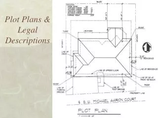
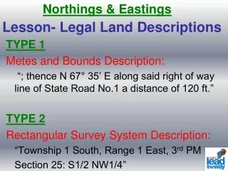
Northings & Eastings Lesson- Legal Land Descriptions • TYPE 1 • Metes and Bounds Description: • “; thence N 67° 35’ E along said right of way line of State Road No.1 a distance of 120 ft.” • TYPE 2 • Rectangular Survey System Description: • “Township 1 South, Range 1 East, 3rd PM • Section 25: S1/2 NW1/4”
Universal Transverse Mercator Coordinate System (UTM) • Means of stating any position on the earth by giving two coordinates: An east coordinate (easting) and a north coordinate (northing) US Zones - UTM
SPCS • State Plane Coordinate System • Based on zones described by political boundaries – states or areas within states • More accurate than UTM
Coordinate System Origin - SPCS • Established by each state – Generally 2 million feet west of the zone’s central meridian and some distance south of the zone’s southernmost point. • Northing – North Coordinate • Easting – East Coordinate
Important Terms • Departure: • A distance in the east-west direction (x-axis) • Latitude: • A distance in the north-south direction (y-axis)
Departure Latitude Graphically Pt. 2 Pt. 1 Professional Development ID Code: 8005
β Right Triangle Trigonometry 1 Departure Distance sin β = Departure = (sin β)(Distance)
β Right Triangle Trigonometry 2 Latitude Distance cos β = Latitude = (cos β)(Distance)
β Ties to Metes and Bounds N 48º E, 200 feet
β Ties to Metes and Bounds Latitude = (cos β)(Length of property line) Departure = (sin β)(Length of property line)
N 48º E, 200 feet Latitude = (cos β)(Length of property line) = (cos 48°)(200 feet) = 133.826 feet Departure = (sin β)(Length of property line) = (sin 48°)(200 feet) = 148.629 feet
Convert to Northing & Easting Latitude added (N direction) or subtracted (South direction) from the previous Northing Departure added (E direction) or subtracted (W direction) from the previous Easting
SOUTH WEST An Example
Latitude and Departure Latitude = (cos β)(Length of property line) = (cos 73°)(249.08 ft) = 72.82 ft Departure = (sin β)(Length of property line) = (sin 73°)(249.08 ft) = 238.20 ft
Northing – End 1st Property Line Latitude = 72.82 ft. Known Benchmark Northing = 1000 ft. Bearing South therefore subtract 72.82 ft. Northing = 927.18 feet at the end of the 1st Property Line
Easting – End 1st Property Line Departure = 238.20 feet Known Benchmark Easting = 1000 ft. Bearing West therefore Subtract 238.20 ft. Easting = 761.80 feet at the end of the 1st Property Line
Latitude and Departure – line 2 Latitude = (cos β)(Length of property line) = (cos 0°)(201.42 ft) = 201.42 feet Departure = (sin β)(Length of property line) = (sin 0°)(201.42 ft) = 0 feet
Northings-Eastings End 2nd Line Latitude = 201.42 ft Previous Northing = 927.18 ft Bearing South therefore subtract 201.42 ft Northing = 725.76 ft at the end of the 2nd Property Line Departure = 0 ft Previous Easting = 761.80 ft Bearing West therefore Subtract 0 ft. Easting = 761.80 feet at the end of the 2nd Property Line
Latitude and Departure – line 3 Latitude = (cos β)(Length of property line) = (cos 83°)(368 ft) = 44.85 feet Departure = (sin β)(Length of property line) = (sin 83°)(368 ft) = 365.26 feet
Northings-Eastings End 3rd Line Departure = 365.26 ft Previous Easting = 761.80 ft Bearing East therefore add 365.26 ft. Easting = 1127.06 feet at the end of the 3rd Property Line Latitude = 44.85 ft Previous Northing = 725.76 ft Bearing North therefore add 44.85 ft Northing = 770.61 ft at the end of the 3rd Property Line
End of 4th Property Line Convert 28º 58´ 53´´ to Decimal: 28º + 58/60º + 53/3600º = 28.9814º
Latitude and Departure – line 4 Latitude = (cos β)(Length of property line) = (cos 28.9814°)(262.23 ft) = 229.39 feet Departure = (sin β)(Length of property line) = (sin 28.9814°)(262.23 ft) = 127.06 feet
Northings-Eastings End 4th Line Latitude = 229.39 ft Previous Northing = 770.61 ft Bearing North therefore add 229.39 ft Northing = 1000 ft at the end of the 4th Property Line Departure = 127.06 ft Previous Easting = 1127.06 ft Bearing West therefore subtract 127.06 ft. Easting = 1000 feet at the end of the 4th Property Line
Using Software Click here to download a Template for Calculating Northings and Eastings Using Excel