Download
1 / 20
200 likes | 227 Vues
Understand the basics of plot plans and legal descriptions, including Metes and Bounds, Rectangular, and Lot and Block systems. Learn about the importance of legal descriptions and the requirements of a thorough plot plan.

E N D
Site or Plot Plans • A plot or site is an area of land generally one lot or construction site in size • The term plot is synonymous with lot • A plat is a map of part of a city or township showing some specific area, such as a subdivision made of several individual lots • Usually may plots in one plat
Legal Descriptions • Legal descriptions are a technical and detailed record of property in the United States • Legal descriptions are public record • An architect uses legal descriptions to establish the layout of the proposed property • Basic types of legal descriptions: • 1) metes and bounds system • 2) rectangular system • 3) lot and block system
1) Metes and Bounds System • Metes meaning measurements • Bounds meaning boundaries that exist • These two terms, metes and bounds, are used to identify the perimeters of property • Units of measurements - feet, yards, rods, & chains • Identified boundaries may be - street, fence, & rivers • Boundaries are also identified by bearings • Starts with a monument, point of beginning (POB) • pile of rocks, large tree, iron rod driven in ground
pipe center of road Metes and Bounds - Example • Beginning at a point 1200 ft. north 40° west from the southeast corner of the Asa Stone donation Land Claim No 49, thence north 40° west 1026 ft to a pipe, thence south 56° 45’ west 442 ft chains to center of road, thence south 23°15’ east 1145 ft, thence north 48°30’ east 778.8 ft to POB
2) Rectangular System • Used today in areas called the public land states:western boundary of Ohio & including some southeastern states to the Pacific Ocean • Also known as the great land surveys because of the use of parallels of latitude and meridians of longitude • Parallels or base lines are lines of latitude • Principle meridians are lines of longitude • 34 total sets of these lines, 31 in continental USA & 3 in Alaska
Rectangular System • Land divided into identifiable areas and size all starting at the intersection of the meridians and base line, this starting point is called the initial point • Quadrangles= 24 mile square, 576 square miles, contains 16 townships • Townships = 6 mile square, 36 square miles, contains 36 sections, identified as: T3N, R38E T = tier or township (north & south), R = Range (east & west), both numbering start at the initial point • Sections = 1 mile square, 1 square mile, contains 640 acres (5280’ X 5280’)with smaller division noted as section quarters (160 acre) and quarters of quarter sections • One mile = 5280 feet One acre = 43,560 square feet
Rectangular System - Townships • Townships • Set by Tier/Town-ships and ranges
Rectangular System - Sections • Sections numbering system • 36 Sections in a township
Rectangular System - Sections • Dividing a section into quarters and quarters of quarters • How to designate these divisions
Rectangular System-Legal Description Example • Legal description: Commencing at a point 693 feet south and 1386.75 feet east of the northwest corner of Section 25, Township 6 North, Range 39 East, Boise Meridian, in Madison County, State of Idaho, and running thence South 313.5 feet; thence South 89° 53’ East 139 feet; thence North 313.5 feet; thence North 89° 53’ West 139 feet to point of beginning, containing approximately one acre.
Rectangular System • Example of Plot Plan
3) Lot and Block System • Derived from either metes and bounds or rectangular system, however when a parcel of land is subdivided usually names are given for the subdivision, numbering blocks within the subdivision and numbering lots within a block. • Example of how this comes together as a typical lot & block description: • Lot 14, Block 12, Lincoln Park No. 3, City of Salem, State.
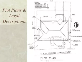
The Plot Plan Requirements • Plot plan is known as a lot plan • Plot plans may showtopography with contour lines (sometimes this is on a separate drawing) • Plot plans may show numerical values of land elevation (usually at property corners and/or corners of building • Plot plans may show excavation at the site (usually known as a grading plan)
The Plot Plan Requirements (pg 148) • Legal description of the property • to include any roads and property easements or right-of-ways • Property line lengths and bearings • North direction (normal direction of north towards top of sheet) • Location of utility services (water, sewer, gas line & sizes along with electrical power service) • Title of drawing is identified as Plot Plan or Site Plan, scale of drawing is included
The Plot Plan Requirements (pg 148) • Elevations at property corners (minimum) • contours and other topography of site • House positioned and located with dimensions perpendicular to property lines • Driveways, patios, walks located and sized • Setbacks dimensioned-- front, rear, and sides • Existing and proposed landscaping (sometimes placed on separate landscaping plan
Plot Plan Example • 1) Title and scale with north direction • Items to note: • 2) Circle and elevations at the lot corners & also @ bldg corners • 3) Bearings and distances on property lines • 4) Dimensioning/callouts • 5) Landscaping & contours • 6) Utilities 7) LegalDescription • 8) Drawing Legend