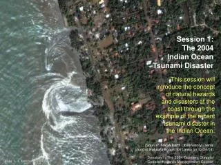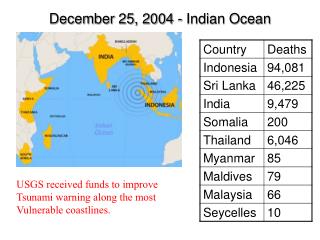
December 25, 2004 - Indian Ocean
150 likes | 411 Vues
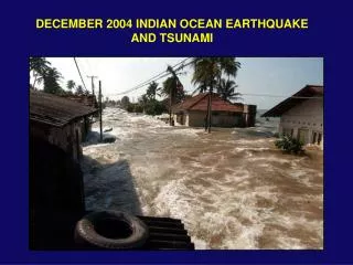
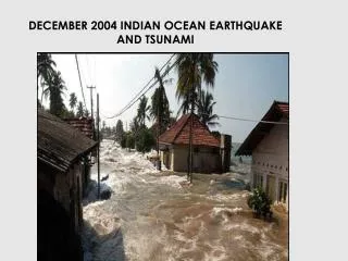
December 25, 2004 - Indian Ocean. USGS received funds to improve Tsunami warning along the most Vulnerable coastlines. Tsunami in the Caribbean. 27 tsunamis has been verified, 91 recorded Over 9,500 fatalities Affected 22 countries

December 25, 2004 - Indian Ocean
E N D
Presentation Transcript
December 25, 2004 - Indian Ocean USGS received funds to improve Tsunami warning along the most Vulnerable coastlines.
Tsunami in the Caribbean 27 tsunamis has been verified, 91 recorded Over 9,500 fatalities Affected 22 countries Last known Caribbean Tsunami 2003, Guadeloupe, 75m inland, Damage boats. Last destructive Caribbean Tsunami was in 1946 Caribbean more developed since 1946
Historical Destructive Caribbean Tsunamis 1692, Jamaica, Port Royal, 2000 Killed? 1755 Lisbon Tele-Tsunami, 7m run at Saba, 3.6 in Antigua, 4.5 m in St. Martin 1967 November 18, M7.5 earthquake in the Anagada Trough, 18.3m runup at Guadeloupe, 6.1m in St Croix 1918 Puerto Rico, M7.5 earthquake in the Mona Passage, 6m run up in PR 1946 Puerto Rico, DR, Haiti, 1700 dead (75 in Magagues), 20,000 homeless. Arrived 35 minutes after the earthquake
Damage caused by the 1918 tsunami to homes along Puerto Rico's western shore (possibly at Mayaguez). Several homes, such as the one shown above, were carried out into the ocean during the recession of water that followed the surge of the first tsunami wave crest. • The USS Monongahela on the beach at Fredriksted, St. Croix, after the 1867 Virgin Island tsunami.
Eastern Caribbean Fatalities from Earthquakes and Tsunamis (1500 – 1999) Total Deaths – 16,500 Total Deaths – 360, 20 events
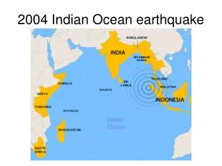
Tectonic Setting cont’d Caribbean Plate Northern & Eastern margins areOcean-Ocean plate boundary South-eastern margin – Triple junction Eastern margin – Subduction Zone >> Volcanism & Inclined plane seismicity Northern margin – Subduction, Strike-Slip and spreading zone
Historical tsunamis in the Caribbean Source: Zaibo et al, 2003
Caribbean earthquakes since 1964 In 1964 the UWI Seismic Research Unit in Trinidad began monitoring the region. Seismic Research Unit The University of the West Indies St. Augustine Trinidad
Hazard is expressed at the probability that a certain ground motion parameter is not exceeded within a given time.
Submarine Landslides NOAA image of the ocean floor bathymetry north of Puerto Rico. Two past submarine landslides are visable as headscarps (labeled Loiza and Arecibo Amphitheaters). Sea floor fissures are indicated by black arrows and dashed lines outline debris flow from past failures. (Map: Uri Ten Brink USGS).