Download
1 / 53
650 likes | 1.17k Vues
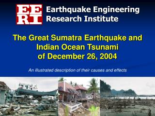
The Great Sumatra Earthquake and Indian Ocean Tsunami of December 26, 2004. Earthquake Engineering. Research Institute. An illustrated description of their causes and effects. Preface.

E N D
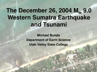
The Great Sumatra Earthquake and Indian Ocean Tsunami of December 26, 2004 Earthquake Engineering Research Institute An illustrated description of their causes and effects
Preface This presentation was developed to explain the origins of the Sumatra earthquake of December 26, 2004 and the ensuing tsunami, and to document the damages caused by the earthquake and tsunami in so many countries around the Indian Ocean. • The presentation was created largely by Widianto, a doctoral candidate in civil engineering and president of the EERI student chapter at the University of Texas at Austin. • Other contributors include Sarah Nathe, Craig Comartin, and Heidi Faison. This project was supported by funds from the National Science Foundation through EERI’s Learning From Earthquakes Program under grant # CMS-0131895
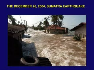
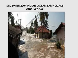
“The 26th December 2004 Sumatra-Andaman earthquake is the fourth largest earthquake in the world since 1900 and is the largest since the 1964 Prince William Sound, Alaska earthquake.” United States Geological Survey (USGS) “The tsunami that struck Southeast Asia on December 26, 2004 has been confirmed as the most devastating in modern history.” Guinness Book of World Records
Contents • Introduction: Plate tectonics, earthquakes • Sumatra Earthquake - Tectonic activity - Observations - Damage • Indian Ocean Tsunami - Basic mechanism - Videos: before and after giant wave arrival - Damage • Tsunamis in the USA • Tsunami Risk Reduction • The Earthquake Engineering Research Institute
Introduction – Plate Tectonics • The Earth is characterized by a small number of lithospheric plates that float on a viscous underlayer called the asthenosphere. • Geological evidence shows that plates undergo constant, gradual change. Magma is continually upwelling at the mid-oceanic ridges and rises as the seafloor spreads apart. • In some areas, large sections of plates are forced to move beneath other plates (surface layers of rocks are absorbed into the earth’s interior). These areas are called subduction zones. A plate being subducted beneath another
Introduction – Plate Tectonics Source: Earthquakes by Bruce A. Bolt
Introduction – Plate Tectonics 95% of earthquakes occur along the edges of the interacting plates Source: Earthquakes by Bruce A. Bolt
World’s Largest Magnitude Earthquakes Source: United States Geological Survey (USGS)
Earthquake Energy Sumatra-Andaman (2004) Source: Earthquakes by Bruce A. Bolt
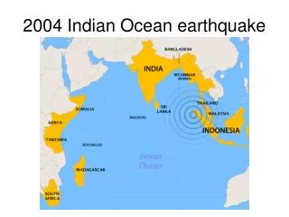
Sumatra Earthquake Magnitude: 9.0 Date-time:Sunday, December 26, 2004 at 7:58:53 AM (local time) Depth: 30 km (18.6 miles) Distances: * 250 km (155 miles) SSE of Aceh, Sumatra, Indonesia * 310 km (195 miles) W of Medan, Sumatra, Indonesia * 1260 km (780 miles) SSW of Bangkok, Thailand * 1605 km (990 miles) NW of Jakarta, Java, Indonesia Source: UnitedStates Geological Survey (USGS)
Tectonic Summary • It occurred on the interface of the India and Burma plates: aninterplate earthquake. • India plate subducts beneath the overriding Burma plate at the Sunda Trench. • In the region of the earthquake, the India plate moves toward the northeast at a rate of about 6 cm/year relative to the Burma plate. • Thrust faulting caused the earthquake (slip directed perpendicular to the trench). • Fault rupture propagated to the northwest from the epicenter with a width 100 km and an average displacement on the fault plane 20 meters. 6 cm/yr Source: United States Geological Survey (USGS)
Felt Shaking Reports • Modified Mercalli Intensity Scale: Source: United States Geological Survey (USGS) • Banda Aceh, Sumatra: IX • Medan, Sumatra: IV • Port Blair, Andaman Islands: VII • Subsidence and landslides were observed in Sumatra. • A mud volcano near Baratang, Andaman Islands began erupting on December 28, 2004. • Intensity vs. Distance from Epicenter Plot :
Aftershock Zone • Extends from Northern Sumatra to the Andaman Islands, ~ 1300 km to the north. • Largest aftershock directly following the main shock was M = 7.1 in the Nicobar Islands. • On March 28, 2005, a M = 8.7 earthquake occurred in a region of the fault southeast of the Dec 26th mainshock and its rupture zone. Epicenter of mainshock, 28 Mar 2005
Earthquake Damage Location: Banda Aceh, Sumatra, Indonesia Photo: Jose Borrero Structural damage to concrete frame building.
Earthquake Damage Location: Banda Aceh, Sumatra, Indonesia Photo: Murat Saatcioglu, Ahmed Ghobarah, Ioan Nistor Partial collapse of concrete frame building due to column failure.
Earthquake Damage Location: Banda Aceh, Sumatra, Indonesia Photos: Murat Saatcioglu, Ahmed Ghobarah, Ioan Nistor Partial collapse of concrete frame building due inadequate column reinforcement.
Earthquake Damage Location: Banda Aceh, Sumatra, Indonesia Architectural damage to the Grand Mosque tower. Photo: Jose Borrero
Earthquake Damage Location: Port Blair, Andaman Islands Column of residential building damaged by ground motion. Source: Geological Survey of India
Earthquake Damage Longitudinal (50 m long) crack on Kamraj Road after the earthquake Location: Port Blair, Andaman Islands Major crack showing a rupture width of 15 cm on Kamraj Road after the earthquake Source: Geological Survey of India
Earthquake and Tsunami Not all earthquakes generate tsunamis. An earthquake must have certain characteristics in order to generate a tsunami: 1. Epicenter is underneath or near the ocean. 2. Fault causes vertical movement of the sea floor (up to several meters) over a large area (up to 100,000 km2). 3. Large magnitude ( > 7.5 ) AND shallow focus ( < 70 km). Source: Earthquakes by Bruce A. Bolt
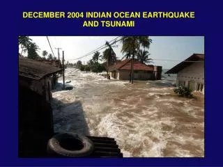
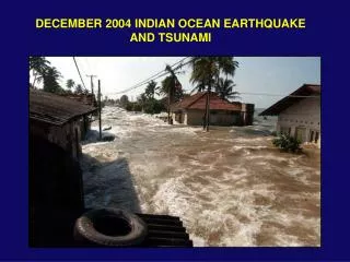
Basic Tsunami Mechanism • An earthquake causes a vertical movement of the seafloor, which displaces the sea water. • Large waves then radiate from the epicenter in all directions.
Tsunami Explained • A tsunami is series of traveling ocean waves of extremely long length generated primarily by earthquakes occurring below or near the ocean floor. • Tsunami waves propagate across the deep ocean with a speed exceeding 800 km/h ( 500 mph) and a wave height of only a few tens of centimeters or less. • As they reach the shallow waters of the coast, the waves slow down and their height increases up to tens of meters (30 ft) or more. Source: NOAA
Tsunami Translated Japanese word: “Tsu“ means “harbor” English translation: “Harbor wave” “Nami“ means “wave” • “Tidal wave” is a misnomer because the cause is unrelated to tides. • “Seismic sea wave” is misleading because a tsunami can be caused by non-seismic events, and it is not dangerous in the open ocean.
Water Recession: A Precursor Draw Down Effect Wave Generation From: Nature Publishing Group From: Nature Publishing Group Kalutara Beach, Sri Lanka From: Digital Globe
Tsunami Wave Appearance Source: www.waveofdestruction.org • A tsunami wave crest has three general appearances from shore: • Fast-rising tide • Cresting wave • A step-like change in the water level that advances rapidly (called a bore) A bore on the Qian Tang Jiang River, China • Series of waves • Most tsunamis come in a series of waves that may last for several hours • The outflow of water back to the sea between waves can cause more damage than the original incoming wave fronts • The first wave is rarely the largest
Tsunami Propagation National Institute of Advanced Industrial Science and Technology, Japan
Tsunami Damage Location: Lhoknga, Indonesia Before Tsunami January 10, 2003 After Tsunami December 29, 2004 Source: National University of Singapore
Tsunami Damage Location: Lhoknga, Indonesia Exposed bridge piers of road that washed away. Photo: Jose Borrero High Water Mark Overturned ship Damage zone showing an overturned tanker, trees snapped in half, and the high water mark on islands where vegetation was stripped away. Broken Trees Photo: Jose Borrero
Tsunami Damage Location: Gleebruk, Indonesia Before Tsunami April 12, 2004 After Tsunami January 2, 2005 Source: Digital Globe
Tsunami Damage Before Tsunami April 12, 2004 After Tsunami January 2, 2005 Source: Digital Globe
Tsunami Damage Location: Banda Aceh, Indonesia Before Tsunami June 23, 2004 After Tsunami December 28, 2004 Source: Digital Globe
Tsunami Damage Location: Banda Aceh, Indonesia A boat was lifted on top of houses by the waves. Photo:Jose Borrero Damage was caused by both water and water-borne debris. Photo: Jose Borrero
Tsunami Damage Location: Banda Aceh & Lhoknga, Indonesia The tsunami waves came from many directions and flowed across the tip of northeastern Sumatra. Graphic: Jose Borrero
Tsunami Damage Location: Thailand Thailand Damage to Kao Lak Resort from tsunami waves. Photo: Curt Edwards Despite the presence of debris, this naval base building had little structural damage due to a retaining wall at its frontage. Photo: Chitr Lilavivat
Tsunami Damage Location: Sri Lanka Flow depths were about 4.5 m at Yala Safari Resort, where water levels were determined by debris in the trees (see door impaled on branch). Sri Lanka Damage to house in Tangala.
Tsunami Damage Location: Kerala, India The collapsed front portion of a concrete house. In the village of Alappad, the foundations and the soil beneath many of the houses were scoured out. Source: Geological Survey of India
Tsunamis in the U.S.A. • The west coast, from California to Alaska, is vulnerable to tsunamis from nearby or distant earthquakes. • Hawaii is extremely vulnerable to all tsunamis in the Pacific Ocean. • California, Oregon, Washington, Alaska and Hawaii all have tsunami education programs for residents and visitors, coastal signage, and warning response plans. Photo: Eugene Schader, NISEE Collection Photo: Kirkpatrick, NISEE Collection Warped pier in Crescent City, CA caused by 1964 Alaska earthquake tsunami Tsunami induced damage in Seward, Alaska from 1964 Alaska earthquake
Historical Tsunamis in the U.S.A. Sources: NOVA; International Tsunami Information Center (ITIC)
Tsunami Risk Reduction • Determine & understand community tsunami risk • Hazard: • Study the shape of the sea floor and the coastal topography • Run simulations of tsunamis • Vulnerability: • Develop maps of potential risk areas • Exposure: • Costal communities, especially with tsunami history risk • Avoid new development in tsunami run-up areas • Designate risk areas as open-space, i.e., parks and agriculture • Zone to minimize human risk • Low density residential zoning • Large single-residence lots city planning
Tsunami Risk Reduction • Locate and configure new development in the run-up areas to minimize future tsunami losses site planning • Avoid inundation areas i.e. build on high ground • Slowing water currents i.e. Conserve or replant coastal belts of forest and mangrove swamps • Steering water forces i.e. angled, by-pass walls • Blocking water forces i.e. Build sea walls SLOWING STEERING Source: National Tsunami Hazard Mitigation Program (NTHMP) BLOCKING
Elevated restaurant in Hilo, Hawaii. Lower level is designed to allow waves to pass through. Source: National Tsunami Hazard Mitigation Program Tsunami Risk Reduction • Design and construct new buildings to minimize tsunami damage • Heavy and rigid structure • Raise building on stilts* • Many openings on the ground floor * • Orient perpendicular to the shoreline: tsunami-resistant building *Use caution with this design in areas with high earthquake-shaking risk.
Tsunami Risk Reduction 4.Tsunami-resistant buildings (cont.) Tsunami forces on structures Structure designed to resist tsunami forces Source: National Tsunami Hazard Mitigation Program (NTHMP)
Caveat: Remember Earthquake-Resistant Design Principles • Most communities at risk from tsunamis are also at risk from damaging earthquakes • Buildings designed well for earthquakes typically perform well in tsunamis Photo: Jose Borrero Photo: Jose Borrero Well-designed building withstood tsunami forces without collapse in Banda Aceh, Indonesia Well-designed building standing amidst the rubble in Banda Aceh, Indonesia
Tsunami Risk Reduction • Protect existing development through redevelopment, retrofit, and land reuse plans and projects • Take special precautions in locating and designing infrastructure and critical facilities • Locate critical infrastructure (water plants, hospitals, etc) outside the tsunami danger zone • Relocate or protect critical infrastructure • Plan for emergency and recovery city planning city planning
Tsunami Risk Reduction • Plan for Evacuation • Identify vertical evacuation buildings • Create horizontal evacuation routes • Develop early warning systems • Educate and inform public warning
Tsunami Risk Reduction Tsunami early warning system: • Pressure sensors sit on the ocean bottom and measure the weight of water column above them. • If a tsunami passes overhead, the pressure increases and the sensor sends a signal to a buoy sitting on the sea surface. • The buoy then sends a signal to a satellite, which in turn alerts a staffed early warning center.
Tsunami Risk Reduction The least expensive and the most important mitigation effort is … EDUCATION "Even without a warning system, even in places where they didn't feel the earthquake, if people had simply understood that when you see the water go down, when you hear a rumble from the coast, you don't go down to investigate, you grab your babies and run for your life, many lives would have been saved." Lori Dengler, Humboldt State University New Scientist Magazine January 15, 2005
The power of knowledge: • Victor Desosa saved the village of Galbokka in Sri Lanka because he knew what to do when the water receded. • Only one inhabitant in his village was killed. • Casualty rates in nearby villages were 70 – 90 %
“Natural hazards are inevitable. Natural disasters are not.” John Filson, USGS retired New York Times December 27, 2004
Earthquake EngineeringResearch Institute • EERI is a professional, association dedicated to reducing earthquake risk. • Members of EERI work in the many different fields of research and professional practice dedicated to reducing earthquake losses.