Download
1 / 59
600 likes | 862 Vues
The M9.0 Andaman Islands-Sumatra Earthquake and Tsunami of 26 December 2004. Discovery Lecture, Dept. of Earth and Atmospheric Sciences, Purdue University February 28, 2005 Prof. Larry Braile, braile@purdue.edu , www.eas.purdue.edu/~braile.

E N D
The M9.0 Andaman Islands-Sumatra Earthquake and Tsunami of 26 December 2004 Discovery Lecture, Dept. of Earth and Atmospheric Sciences, Purdue University February 28, 2005 Prof. Larry Braile,braile@purdue.edu, www.eas.purdue.edu/~braile (Despite the popularity of this image, tsunami waves do not normally look like this.)
Tectonic Setting USGS
Schematic plate tectonic setting for tsunami generation TRENCH NOAA Commonly, in mega-thrust earthquakes, a very large area of the ocean floor is uplifted
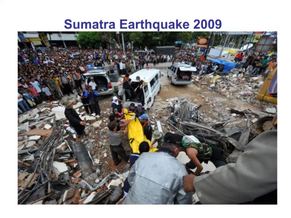
Historical Seismicity (Indonesia is one of the most seismically active areas in the world, has a long subduction zone plate boundary, and many 7+ earthquakes have occurred there in the past, so it should be no surprise that an M9+ tsunami-generating event would occur there.)
Sumatra earthquakes FAQs Question: What other great (M > 8) earthquakes have occurred in the region? Answer: Since 1900 and prior to the December 26 earthquake, the largest earthquake along the subduction zone from southern Sumatra to the Andaman Islands occurred in 2000 and had a magnitude of 7.9. A magnitude 8.4 earthquake occurred in 1797, a magnitude 8.5 in 1861 and a magnitude 8.7 in 1833 . All three ruptured sections of the subduction zone to the south of the recent earthquake. Interestingly, the 1797 and 1833 quakes are believed to have ruptured roughly the same area with only 36 years separating the events. Paleoseismic evidence shows that great earthquakes or earthquake couplets occur about every 230 years (http://www.gps.caltech.edu/~sieh/publications/a10.html). USGS
Show earthquake activity in Indonesia and aftershocks of the 26 December earthquake using the Seismic Eruption program (written by Alan Jones, SUNY-Binghamton) http://www.geol.binghamton.edu/faculty/jones/
Main shock and aftershocks ~1200 km of the plate boundary moved, max. displacement ~ 15 m (?, preliminary est.) USGS
24-hour seismograph record ~135 degrees distance
Worldwide earthquakes per year: Frequency-magnitude relationship suggests that magnitude 9+ events will occur about once per decade; statistically, since 1900, the actual number is ~once per 20 years.
Magnitude of earthquake is controlled by fault length that ruptures (data for diagram generated using Seismic/Eruption program) Magnitude versus fault length (determined from aftershock zone length) for various earthquakes (Alaska, 1964; Denali, 2002; Landers, 1992; Loma Prieta, 1989; Northridge, 1994, etc.). Results were quickly obtained using Seismic/Eruption views. Alaska, 1964 Sumatra, 2004 Denali, 2002 Landers, 1992
Some recent Tsunamis NOAA
Question: What other significant tsunamis have occurred in the region? Answer: The following destructive tsunamis are listed on a data base maintained by the Tsunami Laboratory, Institute of Computational Mathematics and Mathematical Geophysics (http://tsun.sscc.ru/tsulab/20041226tsun.htm) 1. 1797/02/10 Central part of the western Sumatra. The quake was most felt near Padang and in the area within +/-2 deg of equator. Padang was flooded by powerful waves. More then 300 fatalities. 2. 1833/11/24 South coast of the western Sumatra, estimated rupture from 1 S to 6 S latitude. Huge tidal wave flooded all southern part of the western Sumatra. Numerous victims. 3. 1843/01/05 Strong earthquake west of the central Sumatra. Terrible wave came from the south-east and flooded all the coast of the Nias Island. Many fatalities. 4. 1861/02/16 Exceptionally strong earthquake affected all the western coast of Sumatra. Several thousand fatalities. 5. 1883 Krakatau explosion 36,000 fatalities USGS
Tsunami wave height (2 hours after earthquake) measured from satellite radar altimetry NOAA
Satellite radar altimetry Gower, J., EOS, v. 86, no. 4, 25 January, 2005
Tsunami wave propagation characteristics – note that as water depth becomes smaller, waves slow down, become shorter wavelength, and have larger amplitude NOAA When the water is 10 m deep, what is the separation of the waves in minutes?
Water waves animation Direction of propagation Animation courtesy of Dr. Dan Russell, Kettering University http://www.gmi.edu/~drussell/demos.html
Tsunami simulation http://staff.aist.go.jp/kenji.satake/animation.gif
Tsunami simulations Open Quick Time simulations (see these websites) http://www.pmel.noaa.gov/tsunami/ http://www.pmel.noaa.gov/tsunami/Mov/TITOV-INDO2004.mov http://es.ucsc.edu/~ward/indo.mov Note distance of propagation and reflection of waves
Double click on the file: TITOV-INDO2004[1].mov To view Quick Time movie of Tsunami simulation from NOAA http://www.pmel.noaa.gov/tsunami/Mov/TITOV-INDO2004.mov Also, simulation from S. Ward, UCSC: indo[1].mov http://es.ucsc.edu/~ward/indo.mov
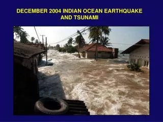
Show video segments of tsunami waves and damage Source: http://www.asiantsunamivideos.com/
Chedi Resort, Phuket, Thailand, Wave height ~4+ m (?, from estimates of water level from beach umbrellas on grassy area above the beach)
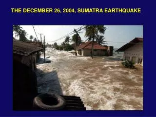
Earthquake and Tsunami Damage, Banda Aceh, Sumatra
Earthquake and Tsunami Damage, Sri Lanka
Commonly, the water recedes (a wave trough) significantly for a few minutes before the first wave crest arrives. People often go out to explore the beach or gather fish or shells at that time.
Banda Aceh, Sumatra, before tsunami http://geo-world.org/tsunami/
Banda Aceh, Sumatra, after tsunami Also: http://www.digitalglobe.com/
Factors that increased loss of life and damage 1. Magnitude of earthquake – largest event in 40 years; and location near highly populated coastlines. 2. Approximately north-south orientation of the plate boundary that focused energy to the west and east.
3. Location off the coast of Sumatra (?) N. Sumatra west coast S. Am.
4. the lack of a tsunami warning system and adequate rapid communication systems
DART tsunami warning system DART: Deep ocean Assessment and Reporting of Tsunamis NOAA
5. the lack of adequate public awareness of tsunamis and tsunami hazards (Although the 26 December 2004 earthquake and tsunami was a tragic event, two benefits are: that countries are now committed to installing effective tsunami warning systems worldwide, and, there is greatly increased public awareness of tsunamis and tsunami hazards.)
Many people watched the waves approach and did not take action until too late, or went out to explore the beach during a wave trough
6. the common building construction characteristics in developing countries
Some significant observations and occurrences • Tsunami warning system could have saved many lives (many deaths occurred as tsunami hit over two hours after the earthquake). • In Sumatra, experiencing the strong earthquake caused some people to move to higher ground; however, many did not. • Apparently, many animals sensed the seismic waves, the sound of the tsunami waves approaching, or the vibration of the ground caused by crashing ocean waves, and moved to higher ground. • Many people watched the waves approach or went out to explore the beach during a wave trough (receding water). • A 10-year old girl is credited with saving about 100 people on a beach in Thailand when she noticed the water receding suddenly and told her mother that it looked like a Tsunami was approaching – a lesson that she had recently learned in school.