Download
1 / 52
520 likes | 686 Vues
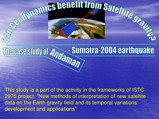
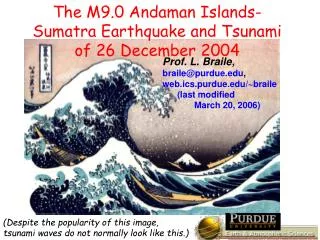
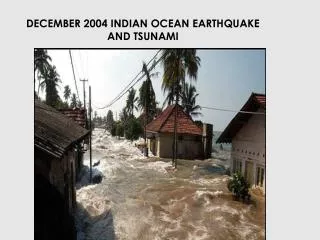
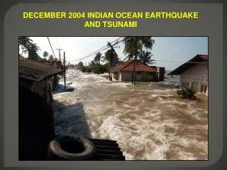
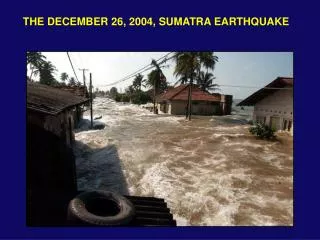
THE DECEMBER 26, 2004, SUMATRA EARTHQUAKE. Burma Microplate. Indian Plate. Sumatra. The process of subduction that has created Indonesia through volcanic activity, also makes it dangerous. INDIAN PLATE MOVES NORTH COLLIDING WITH EURASIA. COMPLEX PLATE BOUNDARY ZONE IN SOUTHEAST ASIA

E N D
Burma Microplate Indian Plate Sumatra The process of subduction that has created Indonesia through volcanic activity, also makes it dangerous.
INDIAN PLATE MOVES NORTH COLLIDING WITH EURASIA
COMPLEX PLATE BOUNDARY ZONE IN SOUTHEAST ASIA Northward motion of India deforms all of the region Many small plates (microplates) and blocks
Note the split in the seismicity into separate thrust and strike-slip faulting.
The Indian plate subducts beneath the Burma microplateat about 50 mm/yrEarthquakes occur at the plate interface along the Sumatra arc (Sunda trench)These are spectacular & destructive results of many years of accumulated motion
STAGE 1: INTERSEISMIC: India subducts beneath Burma microplateat about 50 mm/yr Fault interface is locked
STAGE 1: INTERSEISMIC: India subducts beneath Burma microplateat about 50 mm/yr Fault interface is locked STAGE 2: EARTHQUAKE (COSEISMIC): Fault interface slips, overriding plate rebounds, releasing accumulated motion
STAGE 1: INTERSEISMIC: India subducts beneath Burma microplateat about 50 mm/yr Fault interface is locked STAGE 2: EARTHQUAKE (COSEISMIC): Fault interface slips, overriding plate rebounds, releasing accumulated motion HOW OFTEN MIGHT THEY OCCUR? Fault slipped ~ 10 m = 10000 mm 10000 mm / 50 mm/yr ≈ 200 yr (Last BIG one was in 1833) Faults aren’t exactly periodic for reasons we don’t understand.
Examples of seismograms, showing the ground motions recorded at different locations around the world as a function of time. Note how long in duration these P waves are.
MODELING THESE SEISMOGRAMS shows how slip varied along the fault plane. Most slip along an area ~400 km long Maximum slip ~ 20 m [Contours show time, in seconds] Courtesy of C. Ji
TWO VIEWS OF THE PART OF THE SUMATRA SUBDUCTION ZONE THAT SLIPPED Seismogram analysis shows most slip in southern 400 km Aftershocks show slip extended almost 1200 km Courtesy of C. Ji
For comparison, a magnitude 5 earthquake would rupture a patch roughly the size of New York City's Central Park.
Seismograms show the seismic waves wrapping around the Earth many times. Courtesy of R. Aster
For a large earthquake, seismic waves will continue to circle the Earth for weeks, making it reverberate like a gong. Courtesy of J. Tromp
For a large earthquake, seismic waves will continue to circle the Earth for weeks, making it reverberate like a gong. (Earth’s lowest “fundamental” note, with a period of ~54 minutes, is an E, twenty octaves below middle E on a piano.) Courtesy of J. Tromp
Raw Gravimeter Record Filtered to Show 0S0 and 0S2 0S0 = Blue0S2 = Green 0S0 “Beats” are due to mode splitting. Courtesy of M. Van Camp
The increasing energy with ultralong periods suggests an enormous “slow” earthquake. Courtesy of S. Stein and E. Okal
EARTHQUAKE MAGNITUDE 9.3 Courtesy of IRIS Energy released ≈ 65 × 1017 Joules, or 1,550,000 kilotons (1,550 megatons) of TNT, or the equivalent of 75,000 Hiroshima bombs.
Top Ten List of Earthquakes in the Past 100 Years. Location Date Magnitude 1.Chile 1960 05 22 9.5 2.West Coast of Northern Sumatra 2004 12 26 9.3 3.Prince William Sound, Alaska 1964 03 28 9.2 4.Andreanof Islands, Alaska 1957 03 09 9.1 5.Kamchatka 1952 11 04 9.0 6.Off the Coast of Ecuador 1906 01 31 8.8 7.Rat Islands, Alaska 1965 02 04 8.75 8.Assam – Tibet 1950 08 15 8.6 9/10.Kamchatka 1923 02 03 8.5 9/10.Banda Sea, Indonesia 1938 02 01 8.5
New Okal & Stein value This one earthquake comprises more than ½ of the total energy released by earthquakes during the past 30 years! Courtesy of G. Ekstrom
VERTICAL UPLIFT HORIZONTAL MOTION Courtesy of C. Ji
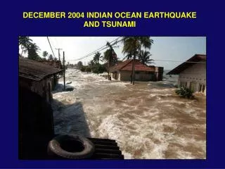
IN DEEP OCEAN tsunami has long wavelength, travels fast, small amplitude - doesn’t affect ships AS IT APPROACHES SHORE, it slows. Since energy is conserved, amplitude builds up - very damaging
TSUNAMI SPEED IN DEEP WATER of depth d c = (gd)1/2 g = 9.8 m/s2 d = 4000 m c = 200 m/s = 720 km/hr = 450 m/hr Tsunami generated along fault, where sea floor displaced, and spreads outward Reached Sri Lanka in 2 hrs, India in 2-3 Courtesy of K. Sataki
Tsunami waves bend around “obstacles” like islands and peninsulas in a process called DIFFRACTION.
Tsunami waves also bend in a process called REFRACTION (according to “Snell’s Law”) as water depth & thus speed changes. SLOW FAST
RAYS BEND AS WATER DEPTH CHANGES DENSITY OF RAYS SHOWS FOCUSING & DEFOCUSING 1 hour
Seen safely from high ground, a wave of the 1960 Chilean tsunami pours into Onagawa, Japan.
Previous Tsunamis in the Sumatra Region 1. 1797: A magnitude 8.4 earthquake near the central part of the western Sumatra generated a tsunami that flooded Padang. More than 300 fatalities. 2. 1833: A magnitude 8.7 earthquake near the south coast of the western Sumatra triggered a huge tsunami that flooded the southern part of western Sumatra. Numerous victims. 3. 1843: A tsunami that came from the southeast and flooded the coast of the Nias Island. Many fatalities. 4. 1861: A magnitude 8.5 earthquake affected all the western coast of Sumatra. Several thousand fatalities. 5. 1881: A magnitude 7.9 earthquake in the Andaman Island region generated a 1 m high tsunami on India’s eastern coast. 6. 1883: Krakatau explosion. 36,000 fatalities, primarily on the islands of Java and Sumatra. 7. 1941: A magnitude ~7.7 Adaman Islands earthquake. Anecdotal accounts exist of a tsunami, however, no official records exist.
….this has very bad consequences! NY Times
Aftermath of the 1960 Chilean tsunami in Hilo, Hawaii, where the tsunami caused 61 deaths.
Waterfront area in Crescent City, California, flooded by the 1960 Chilean tsunami. Here, the tsunami caused more than $30,000 in damage. However, damage was much more severe 600 miles to the south in the Los Angeles area, where the tsunami killed one person and caused from $500,000 to $1,000,000 in damage, including the sinking of 30 boats.
TSUNAMI WARNING SYSTEM Because seismic waves travel much faster (km/s) than tsunamis, rapid analysis of seismograms can identify earthquakes likely to cause major tsunamis and predict when waves will arrive. Deep ocean buoys can measure wave heights, verify tsunami and reduce false alarms.
Changes in Length of Day (due to mass redistribution) Atmospheric Angular Momentum (AAM, in red) and VLBI length of day (LOD, in blue) measurements are strongly correlated over periods of one week to several years (storms, atmospheric currents, El Nino, etc.). Ocean tides and currents modulate the Earth's orientation on periods of a day and shorter. The model (red) follows the VLBI measurements (blue) closely. Predicted change in length of day due to the Sumatra earthquake: -2.676 microseconds (not verifiable?)
The change in polar motion excitation from the earthquake is predicted to be very small, about 0.82 milliarcseconds (also not observable?).