1 / 5

Hazardous Weather Web Briefing For Snow And Ice Wednesday Evening Through Thursday Morning

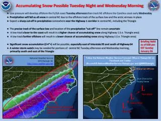
Hazardous Weather Web Briefing For Snow And Ice Wednesday Evening Through Thursday Morning. Winter Storm Watch From Wednesday Evening Through Thursday Morning. Winter Storm Watch Wednesday Evening to Thursday Morning.

lael-murray
Télécharger la présentation

Hazardous Weather Web Briefing For Snow And Ice Wednesday Evening Through Thursday Morning

An Image/Link below is provided (as is) to download presentation Download Policy: Content on the Website is provided to you AS IS for your information and personal use and may not be sold / licensed / shared on other websites without getting consent from its author. Content is provided to you AS IS for your information and personal use only. Download presentation by click this link. While downloading, if for some reason you are not able to download a presentation, the publisher may have deleted the file from their server. During download, if you can't get a presentation, the file might be deleted by the publisher.

E N D

Presentation Transcript


  1. Hazardous Weather Web Briefing For Snow And Ice Wednesday Evening Through Thursday Morning

  2. Winter Storm Watch From Wednesday Evening Through Thursday Morning

  3. Winter Storm Watch Wednesday Evening to Thursday Morning

  4. Timing: Snow beginning late Wednesday, then mixing with sleet and freezing rain by Thursday morning. Total Accumulations: Up to 4 inches of snow north of the Mountain Parkway. Up to 0.5 inch of ice between the Hal Rogers Parkway/Rt. 80 corridor and the Mountain Parkway. Impacts: Slick icy roads. Ice may down tree limbs, trees and power lines. Power outages possible.

  5. For Additional Information weather.gov/jacksonky

More Related